Karankawan Canoe on Vandevere Island - Pringle Lake side off San Antonio Bay

Highmountain

Hero Member
Joined
Mar 31, 2004
Messages
616
Reaction score
33
Golden Thread
0
Location
New Mexico
I don't believe it's ever been recovered. I reported it to the Texas Historical Commission late 1970s or early 80s, along with details and drawings, and contact info, but they didn't seem much interested and never contacted me. I'd guess it's still there.

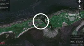
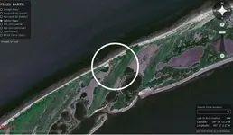
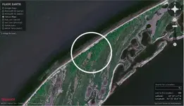
If anyone's interested in trying to locate it I'll try to find some notes I made at the time. It measured 40 feet long, pacing and must weigh a ton or more, so it would take some major effort to recover it. At the time it was half buried, though we dug it out as best we could. Lots of storms since then, but I'd guess it hasn't moved, though it might be buried.
 

Very cool, I wonder if it is still there?

Thats is near Matagorda island park right?

I would love to check out your notes if you get a chance to send them over.

Here is my email:
jason@shawparkservicesllc.com
 

Shaw said:
Very cool, I wonder if it is still there?

Thats is near Matagorda island park right?

I would love to check out your notes if you get a chance to send them over.

Here is my email:
jason@shawparkservicesllc.com

Matagorda Island Park? I don't believe anything of that sort existed at the time. There was a US Fish and Game Wildlife Refuge at Tivoli, but I've never heard of the park. There was a coast guard station either abandoned, or mostly abandoned on that part of Matagorda, but the park throws me.

Maybe they've built some sort of bridge going out there from Tivoli, I suppose. The water between Vandevere and Tivoli was shallow enough in low tide for larger animals such as deer to swim/wade between the Refuge and Vandevere Island.

I'll look for the notes. If I can't find them I'll try to draw a map or give you a good description of where it was located... I don't think it would be difficult to find the place.

Jack

Edit: Incidently, since you evidently go to that area, there's an entirely and long abandoned airforce base across the jetty on the ... I think that side's peninsula. There were and probably are a lot of partially remaining buildings and whatnot, you name it, left if you can stand the mosquitoes. They're a plague.
 

If the notes and azimuths still exist they're buried under a ton of paper. I think finding them would be hopeless.

I pulled up Vandevere on Flashearth.com and it looks as though there's been some washout/wash-through since I was there, but I think the one of screenshots below stand a pretty good shot of being on top of it. If not, you get the idea of the sort of place to look.

The canoe pointed SW/NE, front [south] end was canted downward about 5 degrees and buried deepest. It was upright and aside from being waterlogged was in perfect condition.

You'll want to approach it on the San Antonio Bay side in a shallow draft boat. I was in a flat-bottom and while I was camped out there a bad Norther blew in. I hadn't pulled the boat far enough out of the water to avoid it being swamped, engine half-submerged, gas can floating with only the gasline keeping it from going away when I got up moving around the next morning.

Norther lasted a couple of days with high waves, but I was pressed to get out of there before they had Search and Rescue out looking for us, so I decided to gut it out and head for Port OConner. Crossing the bay the boat would rise, then whack down hitting the bottom of the bay, or the prop tangling up in seaweed or mud all the way to the Inter-Coastal Canal. When we reached the Inter-Coastal we were so cold and wet we poured gasoline out on the ground on shore, set it afire and stood in it trying to warm up.

One of those memorable experiences. I relate it so's you have an idea how shallow that bay is and what kind of weather you want while you're adventuring there.

Hope this helps

Jack
 

Attachments

  • Vandevere Island 28 19 24.9N 96 31 12.2W 72.webp
    Vandevere Island 28 19 24.9N 96 31 12.2W 72.webp
    26.7 KB · Views: 462
  • Vandevere Island 28 19 11.3N 96 32 2.2W 72.webp
    Vandevere Island 28 19 11.3N 96 32 2.2W 72.webp
    27.6 KB · Views: 453
  • Vandevere Island 28 19 1.7N 96 32 20.4W.webp
    Vandevere Island 28 19 1.7N 96 32 20.4W.webp
    27.6 KB · Views: 494
Id definetly be intrested in this I dont understand the maps though is this 3 possible sights?
 

TEXAN Connection said:
Id definetly be intrested in this I dont understand the maps though is this 3 possible sights?

Three locations a short distance apart that have similar characteristics to the place I found it. Longitude/latitude coordinates ought to be fairly precise and the + sign at the center sits atop where it would be. If you look closely where those + signs are located and what's around them you ought to be able to discern what they have in common.

I've not been back there since the early 1980s and though I shot azimuths from the location, I can't retrieve them. So all I have to go by is my memory of what the terrain features were, how far from the shore, how far from my campsite and how it might look now with washouts that weren't there at that time.

Sorry I can't nail it down better.

Jack
 

Highmountain
In 66 to 67 not sure of the year at Bob Hall Pier as you look at it to the right is a ship are large boat.It got uncovered while someone was digging in the sand.You could see the large ribs but it's within the tide range so it got covered up again and I'm sure nobody went after it.It's about 100 to 200 feet from the pier so go and build sand whatever you like until you find it.
Chuck
 

Ridge Runner said:
Highmountain
In 66 to 67 not sure of the year at Bob Hall Pier as you look at it to the right is a ship are large boat.It got uncovered while someone was digging in the sand.You could see the large ribs but it's within the tide range so it got covered up again and I'm sure nobody went after it.It's about 100 to 200 feet from the pier so go and build sand whatever you like until you find it.
Chuck

Chuck: I'm not in that area anymore. Maybe some of the Texas folk will find it useful.

Thanks for the reply
J
 

Looks like Shaw is correct...looks to be right smack in Matagorda Island State Park, which covers a lot of the area and which would make it off limits.
 

I'd bet somebody (archaeologist) would be interested in this canoe.

It would take quite a bit of preservation to avoid drying out, but worth it.

Here's some interesting reading about the Karankawa in the area, for sure the group that left the canoe, including a picture of another canoe:

http://www.texasbeyondhistory.net/morhiss/story.html

Red-River-canoe-sm.jpg
 

Top Member Reactions

Users who are viewing this thread

Back
Top Bottom