map of new york 1891

countrygrammy

Jr. Member
Joined
Sep 15, 2006
Messages
76
Reaction score
3
Golden Thread
0
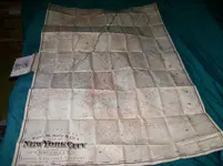
this map is of new york city ,brooklyn ,jersey city and vicinity.271/2 wide 43 long when folded.
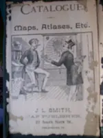
folded it measures 4x6 looks like a book.Publisher j l smith,27 south sixth st,philadelphia pa.
map dated 1891 hope i did this right still learning if not i'll try again.was wondering what its worth.:icon_thumright:
 

Attachments

  • map&ect 022.webp
    map&ect 022.webp
    520.2 KB · Views: 151
I have no idea the worth but that's a neat thing to have in my opinion...
 

I'll still give you $10 for it! :skullflag:
 

messed up some where had three pictures but didnt come up trying again sorry new at this.will try again!!!!!
 

Attachments

  • map&ect 030.webp
    map&ect 030.webp
    610.9 KB · Views: 158
On few months back Antiques road show an early map of the Boston area was estimated to be worth big bucks, aka thousands, it was preserved behind glass and you may wish to do so too...
Because of it's potential, this find deserves a lot more research on your side....
 

i seen the one on road show alway watch that show,This has like fabric backin not sure what it is tho.
 

Just a quick word of friendly advice. DONT FOLD IT UP AGAIN! have it rolled, folded maps lose a ton load of value as it counts towards a defect, collectors love flat none creased maps. Other than that, nice! :)
Take it into an expert to get there opinion as it was obviously folded originaly, but as mentioned above, depending on the map maker etc they can be very valuable
 

Last edited:

Top Member Reactions

Users who are viewing this thread

Back
Top Bottom