Need Directions From Lovelock Or Reno To Rabbit Hole/Rosebud

McArthurJohn

Jr. Member
Joined
Jan 12, 2015
Messages
24
Reaction score
4
Golden Thread
0
Location
McArthur CA
Detector(s) used
Minelab GPX-5000,Minelab GPX-4500, Garrett Infinium, Whites TDI Pro, Whites GMT, Fisher Gold Bug, Whites V3I,Whites DFX
Primary Interest:
All Treasure Hunting
Upvote 0
I usually just follow the maps. I start with the DeLorme Atlas for Nevada. Neither Rosebud, nor Rabbithole are hard to find. Just take Nevada 399 out of Lovelock. When it turns west toward the Eagle Picher Mine, take the north trending road. Follow your map north past the Seven Troughs Range, past Placerites and Scossa. Rosebud Canyon should be to the west. From the nearby Double O Mine (found a little gold there once), Rabbithole will be a few miles southwest. Remember that Rabbithole Springs are in the Black Rock Desert National Conservation Area, which will have regulations different than the surrounding BLM lands. Also, be sure of land status. There are a lot of mining claims in the area. Some private land, too.

If I may ask, what are your plans? That could have some influence on nearby areas some members may suggest you look at. I prefer Sawtooth and Sugarloaf due to the lack of ghost towners.

Nice area out there. Right now, it is a bit cold in Lovelock, so it might be uncomfortable out at the old camps.

Once again, get of a good paper map. Since many phone based GPS apps require cell towers, cell phone or tablet maps may be useless. Enjoy.
 

Backcountry navigator works off gps reliably. You have to save the maps for when you won't have service but I've used it in areas with no reception and it worked well.
 

Make sure its dry when going there, any decent rainfall turns the roads to deep soup. Not a good time yr to go its in teens nights there now, June would be much better time.
 

not looking at going right now, i was figuring early/mid spring. i do VERY well in the rye patch area when i get out . i usually go late spring thru late summer ( early morning and late evening in the summer and NO other detectorists!!!) i couldnt do it now as it is, ive got to go in for a complete left shoulder replacement next tuesday, so ill be down for a couple of months, but im already planning my trips for the summer. ive been to both rabbit hole and rosebud YEARS ago , and didnt do to shabby.

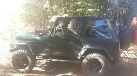
those of you who run around out there have probably seen me. i dont worry much about getting stuck, flats,ect...LOL..most times ive got the top off
20151003_100214.webp

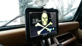
Galenrog, i use an android based GPS called US Topo map ( https://play.google.com/store/apps/details?id=com.atlogis.northamerica.free ) (i use the paid version). its stand alone and not data/cell reliant (although it DOES require data for a couple of the sat view maps, but not all of them) and you can download tons of maps for free from regular topo to satellite view. i HIGHLY recommend it. its about 12 bucks is all for the paid/pro version and it completely rocks. i would recommend a couple things. first, set it to install and download to your SD card, and secondly, get THE BIGGEST SD card you can!.....i spent a few days off and on after i got it downloading maps ( in high resolution), and i think so far ive got about 100gb of maps on my card. do remeber though after you download your maps to remove your SD card, stick it in a reader on your computer and download all the maps off the card as its a pain in the rear to have to redownload everything if your phone or whatever crashes (been there, done that!)...what i did with it is installed it ( the program and maps) on a 10.1" samsung tablet and use that on a mount when im out in the desert. works super.

maybe i can get one or two of you to go out that way with me something this spring and show me the area.....
 

heres my pad i use for GPS mounted in my jeep

20160105_153706.webp
 

I prefer Sawtooth and Sugarloaf due to the lack of ghost towners.
Where's Sugarloaf? I haven't heard of that one. A search in "Placer Gold Deposits of Nevada" turned up the Cope (Mountain City) District, near Sugarloaf Peak it said, is that the place?
 

That is not the one. I was referring to Sugarloaf Knob, northwest of Sulphur. While not a placer area, it is in close proximity to the old Stroud mine, and not too far from the Red Butte mine. The Red Butte has, for people willing to dig a little, some nice copper mineral specimens.

Another area I enjoy is Sawtooth Knob, which has several active claims on the west slopes and adjacent flats.
 

As to the encouragement toward GPS, I have nothing against technology, put I can not pencil in notes on a tablet screen. I do, however, have a SPOT emergency beacon, and access to a satellite phone. Perhaps GPS maps will soon be on the list.
 

you can make note on my pad, its a galaxy note 10.1!,,,has its own pen!
 

i was gonna head out there this next weekend, but my partner cant make it and i dont enjoy going by myself to much.
 

Top Member Reactions

Users who are viewing this thread

Back
Top Bottom