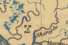
Need help with a topo symbol

WIDirtFishing

Sr. Member
Joined
Apr 29, 2010
Messages
322
Reaction score
129
Golden Thread
0
Location
Twin Cities, MN
Detector(s) used
Minelab Equinox 800

Past:
Tesoro Tiger Shark
Tesoro Silver uMax
AT Pro
Primary Interest:
Metal Detecting

Attachments

  • BM X 641.webp
    BM X 641.webp
    179.4 KB · Views: 175
Upvote 0
usaftrevor87 said:
Was wondering if anyone could help me out with this topo symbol. Not sure what it means and was hoping some pros here could throw me a bone.
It is a map from the 30's and the same symbol appears 3 times on a large map in different spots

That black square indicates a house if that's what your asking.
 

Oh sorry; I should've specified. I meant the BM X 641
 

nevermind; its a Benchmark for elevation. Thanks Though
 

The "BM x 641" means there is a "bench mark tablet" there. That particular tablet is 641 feet above sea level. The best representation of a bm tablet I have ever seen is the one in the "Long Term Visitor Area" south of I 10 near Quartzsite, AZ, on US 95 If you go south into the camping area and watch to the left, you will see a small cement "monument" leaning over and on it you will see a bronze circle showing data on it. I have a pic and hope I can find it for you. The BM's are part of the survey system that occurred many years ago... and, indeed, continue today. TTC
 

Top Member Reactions

Users who are viewing this thread

Back
Top Bottom