Need some help interpreting the landscape on this aerial

Kiros32

Bronze Member
Joined
Feb 21, 2006
Messages
1,407
Reaction score
441
Golden Thread
0
Location
Pittsburgh, PA
Detector(s) used
XP Deus, Whites MXT
Primary Interest:
All Treasure Hunting

Attachments

  • TheHorn.webp
    TheHorn.webp
    155.7 KB · Views: 1,465
Neil in West Jersey said:
Try here:

http://historical.maptech.com/townlist.cfm?stateabr=PA or here: maps.live.com and click on "birds eye view"

Thanks Neil. Unfortunately, this area is too rural for Birds eye view...I hate that because most of the areas I am interested are in rural WV and PA and I can't utilize this feature.

I have the 1876 atlas of the area that show the landowners, and there are no buildings or landowners listed in this area. A friend of mine who owns the property heard a story of a small village there, didn't know the time period. He said he came across a foundation there while hunting this year. He said it was all stone, no trace of brick, which leads me to believe it was probably not lived-in in 1876 and could me much older. Anyway, I am headed out there this weekend to confirm his discovery, but I wanted to gather as much information as I could before I go.
 

Please let us all know how you make out!

GOod Luck,
Neil
 

Ok, no expert here, but see up at near the top - central portion? There are a lot of trees at the water line there. Do you have any idea how old those are? It could be they were planted to help hold the earth in place in case of high waters. As in protecting where folks land from the river.

Also, just behind the trees are several parallel lines (trails?) that could just maybe be some kind of primitive road thing.

No idea, really - but have fun, and let us know how it goes!

HH
Nan
 

roswellborn said:
Ok, no expert here, but see up at near the top - central portion? There are a lot of trees at the water line there. Do you have any idea how old those are? It could be they were planted to help hold the earth in place in case of high waters. As in protecting where folks land from the river.

Also, just behind the trees are several parallel lines (trails?) that could just maybe be some kind of primitive road thing.

No idea, really - but have fun, and let us know how it goes!

HH
Nan

Roswell, I did notice that tree line, it definitely stands out and is certainly a spot I am going to check. I am headed to the county courthouse on Friday to see if I can "dig" up some other maps or warrant information for that area. I will definitely post pics of what I find when I head to the site.
 

also look at the old bridge in the left corner why would someone build a bridge for no reason maybee to visit the town?
 

Does this have anything to do with "The Horn Papers"? It was a hoax back in the early 1930's. Google it and read more...

DCMatt
 

In Pennsylvania, most house or groups of houses built in the early 1800s that I am familiar with were built along the rivers, particularly if the river was navigable. This usually proved a mistake as later floods would leave only a foundation. It would be nice to have the L&L on this to tilt and zoom (doesn't seem to work on your attached copy). If I were to look anywhere in the area given, I like the lower right on the outside of the river bend. Note the rectangular tree formation. Look for a small stream and follow it to the river. I would look (if on the ground) for an Osage Orange tree. While these can be seeded by the river itself, Osage Orange (not eatable) was occasionally planted as boarding (in lack of a fence) or just popular curiosity. In my area I got a shock about ten years ago, when I went to investigate old ruins I had hunted around when I was young. It was like a great army of contractors went down the Juniata building over and developing everywhere. Nothing old remains. The river is manicured clean and sectioned off.
 

i played with the contrast etc
dead center i see a couple of straight line these were probably roads
 

Attachments

  • horny php.webp
    horny php.webp
    170.3 KB · Views: 1,128
 

Attachments

  • horny php.webp
    horny php.webp
    172.3 KB · Views: 1,117
DCMatt said:
Does this have anything to do with "The Horn Papers"? It was a hoax back in the early 1930's. Google it and read more...

DCMatt

Matt,

As far as I know, the "Horn" in this case is just what the local people call the area within the bend of the river there. On older maps, it actually looked like a horn.

Looking forward to heading to Pipsico again in March. Are you coming this time?
 

Kiros32 said:
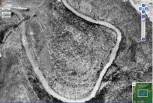
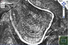
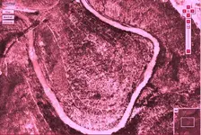
I am told, unconfirmed, that there was once a village on this ridge in what they call "The Horn." As you can see, the river wraps around it. It is a wooded area, so it's a bit difficult to tell if anything is/was there, but I wanted to ask some of the experts if anything stands out to them.

Let me know if you see anything.

Thanks!!

On the left side of the photo in what looks like an oval with the white markings are seen all over Mexico and Arizona on the way to the Superstitions. This is used to show you the way to something, mine, water, etc.
 

Attachments

  • Mexico.webp
    Mexico.webp
    48.1 KB · Views: 930
Very interesting information on the "Horn". It sounds that it should be a unique place to hunt, let me know if you need any assistance. ;D
 

Sorry forgot to tell you the maps are small and if you miss it the map will move if you go to the sides for directions i didnt read it took me 10 mins to figure how to use the maps
 

Top Member Reactions

Users who are viewing this thread

Back
Top Bottom