Re: New Question about 1715 Wreck + Barra d'Ays
Bill
You said Romans' map of 1768. All I have is the one from Burgess & Clausen, which they date at 1775 (which is also the date of his book). It shows, like you said, Merritt Island terminating in the area of the Sebastian River.
IF those are different maps (1768 vs. 1775, in Burgess & Clausen), could you send me a copy of yours (aebrech@aol.com) ?
You're certainly correct about the poor quality of early maps, even De Brahms' and Romans, especially as it pertains to the interior, non-coastal features.
Our paper locating the main town of the Ais does not rely on these maps, but out of thoroughness and full disclosure, we do mention them and assess them. Thanks again,
Alan Brech
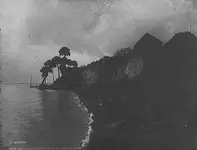
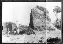
Below is a picture of the last remnant of Barker's Bluff (aka Kroegel Homestead) as it was removed for road-fill in 1904.


 (15 leagues at 2.6 miles = 39 miles and about 40 miles ) both "sides" were quite in agreement that a vessel baring 1715 era goodies went down in the nassau sound area -- humm very close matching info considering the day and that its from 2 differant sources* --(unless high level spys were invovled --- which is highly likely )