Not as much what but why- question

yakker

Bronze Member
Joined
Jan 20, 2012
Messages
1,663
Reaction score
1,240
Golden Thread
0
Location
Down East
Detector(s) used
spec enhanced eyeballs
Primary Interest:
All Treasure Hunting
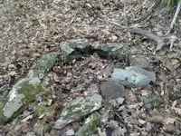
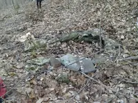
While on same 'car digging' adventure, a friend and I climbed a very steep hill across the river from the old mill site -- where we found a spring, surrounded by stacked stones. 'K' had seen it before, and on all other visits it was dry as a bone. Not a sign of water at all, and had thought maybe it was a (Rev.)war look-out/signalling spot-- or maybe N.A., so I went up with her to see. Turns out it's an active spring which I reckon was jarred back into action after the last little earthquake we had down here. Took some pics and tracked the old pipe (in pieces) down the hill to the river. Now... Why would someone pipe spring water down to a river? The pipes are too new to be from a time of foot or horse traffic (there is a narrow 'road'- grown over- on the opposite side of the river from the mill). It doesn't make sense to me. I'm aware that there were times when rivers were not used as water sources, but there are springs on either side of this river- and easy to spot. And the side where the spring in question is, is not useful for much- too steep, to rocky, and other than lumbering way back- at some point in history, I can't quite fit together why a spring would be a)protected- or marked by a rock surround and b)why it would be piped down to an active/bold river. Anyone have any thought on this. And no, other than pipe, there was nothing to detect up there. Here are some pics. Thanks for any help ;) Yakker

0101151302.webp0101151302a.webp
 
yakker,

Did you detect at the end of the pipe near the river? Any sign of a house there?

Is the river shallow enough to ford at that point? Maybe a ferry was there to bring goods to the mill?

Will you share the location so we can look at images of the site?

DCMatt
 
Upvote 0
The rocks probably supported a roof or covering to keep out leaves and other stuff. This was a gravity fed "running water" set up for a house site. The more drop you have the better pressure and amount of water you get. Years ago, I knew two hippy ladies in Greensboro that moved to and old farm in Fancy Gap Virginia. They had a set up like this up the mountain behind their house that provided enough water and pressure to supply the house and even had nice pressure in the shower without any pump. Country living ended for the ladies when one of them had a salamander come out of the kitchen spigot into her drinking glass.
 
Upvote 0
Upvote 0
river for worm cooling,pipe for distilling water..best guess..still site as plug said
 
Upvote 0
yakker,

Did you detect at the end of the pipe near the river? Any sign of a house there?

Is the river shallow enough to ford at that point? Maybe a ferry was there to bring goods to the mill?

Will you share the location so we can look at images of the site?

DCMatt

I detected only one thing down there- and there's only one. A large-- what looks like a railroad tie. The bolts are 20th C. The river is about 15-20 feet wide (no ferry). Barely cross-able at that point as it's on a bend and channel. There's nothing downstream- where other house-parts might have washed (this river is known to flood, and I am in the outskirts of the 'Camille Zone'). But maybe you're right. But man, I detected till my arm was falling off and couldn't find anything other than that one tie- or beam (around 10x10 inches) mostly buried and I assumed that had something to do w/ logging.

Now, there are stories of now-defunct small guage railroads for quarrying purposes- to get the product to Richmond or wherever. I could understand if there were a steam railroad coming and going along that river, but there wasn't. And this isn't a quarry area. This is an old logging area and during/before that a grist mill.

But the question remains, there's no history of a house on that side of the river. Only logging. It's the mill side where the main road and house, buildings were (and now a home). For a little while I considered that maybe the drinking water for the mill house was coming from across the river- until I learned that there are many visible springs on the mill side. Still scratching head. Thanks for the questions and input ;) Yak
 
Upvote 0
Upvote 0
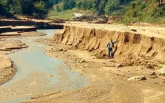
Check the USGS historic TOPO maps for the area. The will show the mill and any buildings in the area. You mention Camille. She may have washed away any traces.

camille_1.webp
DCMatt
 
Upvote 0
BTW... If it is highly visible, not a still. At least not in my experience. Not that I have any experience in that sort of thing... that you know of... :wink:
 
Upvote 0

Users who are viewing this thread

Back
Top Bottom