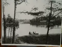
old picture needs identity

CWnut

Hero Member
Joined
May 9, 2003
Messages
591
Reaction score
37
Golden Thread
0
Location
E. Tennessee
Detector(s) used
Tesoro tigershark----Tesoro Conquistador Umax------Fisher FX-3----Master Hunter CX-Plus w/ depth multiplier
Primary Interest:
All Treasure Hunting

Attachments

  • DSCF0001.webp
    DSCF0001.webp
    66.2 KB · Views: 1,206
That's a pretty bid pond and in the current map of Fountain City Park there is no pond. I can't see any pond in the Fountain City area on the online maps.
 

Are you talking about the duck pond at Adair Park?
 

Attachments

  • Adair Park.webp
    Adair Park.webp
    13.8 KB · Views: 1,126
The Pond at Adair
The area that this pond is in was a sheep farm owned by the McCall family.

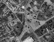
The Lake Forest “lake” is actually a sinkhole and has a name--- “McCall’s Pond.” In the early days, is referred to as McCall's Pond, but today is frequently called the Duck Pond.

Its sister pond, “Butterfly Lake,” is located across Chapman Highway in Colonial Village.The popular Butterfly Lake, our area fishing hole, was the result of a series of sink holes that are along the south side of Colonial Road.


Mr. McCall was killed tragically when struck by a car while he was trying to cross Chapman Highway---the road that cut his farm in two. Today, the two parts of his farm are now well-known South Knoxville neighborhoods---the east side is Lake Forest and the west side is Colonial Village.

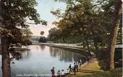
Photo below is of Fountain City Lake /Duck Pond in 1900
 

Attachments

  • Fountain City Lake Duck pond 1900.webp
    Fountain City Lake Duck pond 1900.webp
    68.7 KB · Views: 1,186
Thanks for the replies. Here is a satellite view of the area.(coordinates 36.035-83.933)
 

Attachments

  • fc2.webp
    fc2.webp
    45.1 KB · Views: 1,151

Top Member Reactions

Users who are viewing this thread

Back
Top Bottom