Overlaying Maps

Jbabycsx

Jr. Member
Joined
Sep 19, 2019
Messages
40
Reaction score
74
Golden Thread
0
Location
Georgia
Detector(s) used
Fisher F22
Primary Interest:
All Treasure Hunting
Check out www.maprika.com It's actually a ski app...but works really good for metal detecting...:thumbsup: :thumbsup: If you need any help...give me a shout via PM...

Got-Good-Tones
 

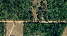
Here’s my crude way of overlaying old maps and current maps . Get your old map with roads , home locations etc , then get a piece of tracing acetate (paper) , lay it on your old map and trace it roads homesites , whatever you want to find . Now go to your computer and pull up google earth of the area. Tape the tracing paper on the computer screen and move , zoom in or out to line up the google earth image to your tracing of the old map and get the best possible match. I use roads and intersections of roads.Drag the push pin icon to each location you want to find and you’ll get a GPS coordinate. You’ll be amazed how accurate the old maps can be and therefore how accurate the GPS cord will be . Hope this helps. MAGA and KAG
 

Last edited:
Historic aerials showed me exactly what I was looking for! Thanks everyone!
 

Historic aerials has a feature that lets you drag an overlay over another.....pretty darn accurately at that.
 

So this is what I’m trying to locate. It’s a school that was across the dirt road next to my land. Assuming that this picture was taken from that road, how far do you think it is from the road? Maybe 25-30 yards? There are no signs of the school that I have ever seen. I suspect those three oak trees may help with pinpointing the location.
 

6AA4B9B4-DF35-4A38-B3A5-5AB3677E3F44.webp
 

Jbabycsx,

Looks to be about 113 feet to front edge of steps (In your photo) from edge of Newtown road...see screen capture from Goggle Earth...will see a outline of a building in the screen capture...

Got-Good-Tones
 

Attachments

  • Esla School.webp
    Esla School.webp
    63.1 KB · Views: 81
Interesting. That’s nowhere near where I was told the school was. That’s about an eighth mile away and currently in someone’s front yard! Lol I guess I will try and get permission to poke around. Thanks!
 

Jbabycsx,

No problem...did some poking around on the internet...That's the GPS coordinates given for the school location. Seems to match up to building layout (Long & Narrow)...and traffic pattern coming out front doors...and the door to the right of the front door. If you look closely at the front of the building shadow...you'll see a very faint pattern that matches up to the respective doors...:icon_thumleft:

Got-Good-Tones
 

Last edited:
Jbabycsx,

Just for fun & giggles...found another document showing the "Esla School" dated 1958...showing that location for the school...but not the school per se. Just that it was there at one point in time...:headbang: 
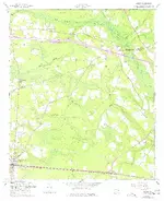
If you go to 100% on the magnification...and look down left side of image...will see numbers...look between 3565 & 3566...and about an inch or so in will see a black square...that would be "Esla School"...or at least where it was at one time..:laughing7:

Got-Good-Tones
 

Attachments

  • GA_Lanier_246135_1958_24000.webp
    GA_Lanier_246135_1958_24000.webp
    1.5 MB · Views: 58

Top Member Reactions

Users who are viewing this thread

Back
Top Bottom