Robbery Loot Cache near old bridge site

Trooper733

Sr. Member
Joined
Apr 3, 2013
Messages
388
Reaction score
315
Golden Thread
0
Location
Eastern Oklahoma
Detector(s) used
Whites V3i,Whites DFX, Whites TRX, Garrett Pro Pointer
Primary Interest:
Other
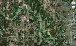
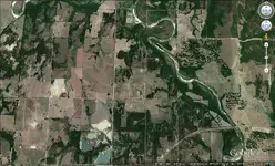
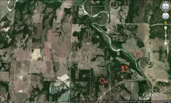
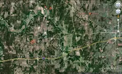
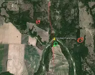
Could someone help me with this image please? The story about this robbery and the buried loot has been handed down to me by a friend who was also a treasure hunter but
has since passed on. He told me the story was that after a robbery of money, which included gold double eagles, silver coins and paper money, the robbers were being pursued and buried the loot on the North side of this river near where there was a bridge span across the river at the time, with dirt mounds as landmarks. The dirt mounds have been removed during crop farming in the area. The site of the bridge is marked with the yellow marker and road paths in red. The river has changed course to some extent making the Ox bow more pronounced and curving further North. I have worked this off and on for several years. Any help is appreciated.
 

Attachments

  • bridge cache (3).webp
    bridge cache (3).webp
    99.3 KB · Views: 223
okiedowser or red desert could you dowse this map for me please?
 

I would like to see a map a little bit below this one..Art
bridge%20cache%20(3).webp
 

Map further South of site

Adding maps as requested, with a 20 mile view and a view directly South of the bridge location showing the old road bed as it existed at the time in red.
 

Attachments

  • 20 mile view.webp
    20 mile view.webp
    206.7 KB · Views: 221
  • further south view.webp
    further south view.webp
    161.7 KB · Views: 219
Stories of treasure get change every time they are told including places...I have gold and silver coins from a robbery in the yellow box...I also have gold and silver in the red box...Art
further%20south%20view.webp
 

Trooper733, didn't get a chance to check your maps yet, have been so busy with yard/garden work outside.
 

Thanks to everyone who helped with this one. Red Desert, would also like your input when and if you have time, thanks again everyone. I will work on this and let you know
 

Go to NETR Online • Historic Aerials

Then type in the coordinates for the bridge.

Click compare then click slide.

Then on one map show the most modern aerial view, on on the other side select the closest to the time period of the robbery. This can be topographic or aerial.

Slide back and forth between the maps and you can see how the river position might have changed, and if the bridge is still in the same place.

This is the most helpful tip I think I can give you.
 

Got a few interesting hits away from the main search area.....hard to tell if even related, but might be worth checking out. The green was getting an archaeological type hit in that area.
 

Attachments

  • further south view-Trooper733.webp
    further south view-Trooper733.webp
    210.1 KB · Views: 193
  • 20 mile view-Trooper733.webp
    20 mile view-Trooper733.webp
    256.8 KB · Views: 196
  • bridge cache (3)-Trooper733.webp
    bridge cache (3)-Trooper733.webp
    111.9 KB · Views: 182
Thanks very much Red Desert, and everyone who contributed. Ill let you know how it comes out. I wish my old friend Loyd Parsons were still alive to help me go for it
 

Thanks for posting your maps and good luck Trooper!
 

Hello Trooper733,
In both pictures, dowsing revealed an attraction to gold and silver (small coin caches)in the areas of the white circles.
Loose coins in the white rectangle area.
Orange rectangle, part of meteorite strewn field. Orange circles are pinpoint concentration areas of chondrite meteorites.
Thanks for posting your pictures.
Jon
bridge20cache(3)dowsed.webpfurthersouthviewdowsed.webp
 

Top Member Reactions

Users who are viewing this thread

Back
Top Bottom