Sebastian Inlet Fla....Research dead-end...need help..

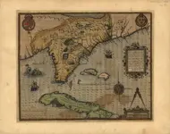
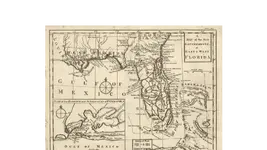
The inlet on that map including the islands is far south of present day Sebastian inlet. It is where todays Ft. Pierce exists and the islands are still there.

IF, You look due West of the inlet you'll see a direct match for what is ( Today called St.Sebastian River). Sure the scale is off, but the location of St.Sebastian River proves its Sebastian inlet.
 

Today > 007.webp 1837 > 006.webp BINGO !
 

Last edited:
Who would of known beyond a shadow of a doubt the real deal ? The local native Indian tribes(as hunters/gathers/fishermen) their lives depended on knowing the lay of the land.IF they made/ kept a written
record that's a different story.And the journey continues,onward to the Seminole Tribe.
 

It shows up on this 1562 map :) Florida, 1562009.webp
And 1800s maps posted above on this site .So I guess that settles it.The Inlet was probably there in the 1700s :)
++++++++++ To Be more exact/precise 1715+++++++++++:occasion14:


It clearly says on old map St. Lucie River. That is 30 miles south of Sebastian Inlet. Ft Pierce Inlet. I've been to both inlets dozens or more times. Your modern google earth map shows Sebastian Inlet & proves nothing as far as age. They are not the same inlets.
 

It shows up on this 1562 map :) Florida, 1562View attachment 1945154
And 1800s maps posted above on this site .So I guess that settles it.The Inlet was probably there in the 1700s :)
++++++++++ To Be more exact/precise 1715+++++++++++:occasion14:

Inlet shown on this map is Stuart Inlet. 50+ miles south of Sebastian Inlet.
 

some Nautical Charts of old

Nautical Chart of the Peninsula of Florida, 1780
french
google translate
Reduced map of the coasts and interior of the Florida peninsula: with the strait of this peninsula
and the Bahama channel, drawn up at the General Depot of maps, plans, and naval journals, according
to different cards combined, for the service of the king's ships
https://www.floridamemory.com/items/show/323266


source
"British Colonial Florida (1763-1783)"
https://www.floridamemory.com/discover/maps/coverage.php


some more Florida Nautical Charts
https://www.loc.gov/maps/?c=50&dates=1700/1799&fa=subject:florida|subject:nautical+charts&st=list
https://www.floridamemory.com/discover/maps/format.php


click to enlarge
https://www.nauticalchartsonline.co...L-1900-Atlantic-Coast-Cape-Canaveral-To-Fowey
https://www.nauticalchartsonline.com/charts/historical/All
 

It clearly says on old map St. Lucie River. That is 30 miles south of Sebastian Inlet. Ft Pierce Inlet. I've been to both inlets dozens or more times. Your modern google earth map shows Sebastian Inlet & proves nothing as far as age. They are not the same inlets.

I know what the old 'hand drawn map says'. Forget about that. Compare the river on both the old & new maps (on the West shore of Indian River). They are very close to being identical (considering the old map was hand drawn). St. Sebastian River can't be in two places
 

Last edited:
Here are my 3 earliest maps in my files. They don't want to expand enough without losing clarity but maybe somebody can see the detail.
 

Attachments

  • florida 1591.webp
    florida 1591.webp
    67.3 KB · Views: 51
  • 1763 Florida.webp
    1763 Florida.webp
    87.3 KB · Views: 56
  • 1775 Florida.webp
    1775 Florida.webp
    292.2 KB · Views: 51
I have the book that John Lee Williams wrote about his travels in Florida in which he generated the map I posted a link to. On page 53 he speaks of the east coast in great detail about the Indian River.He says that "Jupiter Inlet has opened and closed three times, within 70 years. There are at this time, three inlets. The old Indian Inlet, 40 miles below Cape Canaveral, St. Lucia Inlet and Jupiter Inlet, all of which are shoal and appear to be closing up." He says a lot more but but the general idea here is that the Indian inlet on the map I posted is said by Williams to be 40 miles below Cape Canaveral....and today if we distanced the trip from point A to point B, you will find that the Sebastian Inlet is where the Indian Inlet is located on the 1837 map. Not sure if thats what we are even after at this point. Hope it helps.
 

Last edited:
One more thing. Keep in mind that an 1837 map may not be exact when referencing Sebastian River and the Indian River inlet....but the two are close enough when comparing a modern map, that it can be seen as being the same inlet that is being questioned here. But the 40 mile note in his book tells the tale. I believe the actual distance is said to be 39 miles.....a near perfect match.
 

Inlets have opened and closed up and down the east coast over time.

At the time of a map's making it may be open... the next time a mp is made... its closed.

Like i stated in the beginning... its constant change.

Storms were more prevalent back then and opening / cuts would be "on the move" all the time.

I have maps that show no less than 10 inlets ... i have maps that show there are no "inlets"... and fragmented long islands.

AND... inlets MOVE... open and shut.... open and shut... open and shut......

IF you do not believe me... then... heh

Um... i will show you ONE map.

In this map it states... "Jupiter inlet"... "now shut"... it is from 1823.


So... put this in your pipe and smoke it. heh

It may open 5 miles south of Sebastian... then next time 5 miles north... OR TEN... OR TWENTY.... and so on. and so on.

I stopped posting due to RTR's lack of acknowledgements / responses etc... I guess he got sensitive in The Random Chat Thread... or ? ? ?

:P
 

Last edited:
One thing for sure after century's of looking for the 1715 loot (half of it) still hasn't been found. Why ? Most of the attention has been focused on the ocean & beaches. I think the 1715 hurricane and dozens of hurricanes that followed w/in the past 300+ years has moved the loot inland ( into the Indian river and some of it even further West). A storm strong enough that it split one Galleon in half and wash another Galleon 100 yards inland would of had no problem depositing a ship or two and their cargo to the West.The path of least resistance...A Inlet,any inlet,pick one.
Paintings from actual 1715 survivors sketches.>>>005.webp001.webp014.webp
 

Last edited:
I don,t know a lot about beaches or inlets but here on the lower Arkansas River it changes all the time,what was once land is now river and vice versa.I,ve seen it eat up a 1/2 mile of river bank in 48 hours.Where moving water,current or tides are concerned change is a constant.
 

I just observed some things doing 2 google searches:
Sebastian inlet history
Sebastian inlet history books
Maybe check these out, hope it helps.
Welcome!
Jon 8-):cat::occasion14::headbang:
 

I've investigated this decades ago and Im afraid you're reading something into this that isn't there. The St. Lucie river west of the St Lucie inlet is Ft. Pierce inlet.. except in the time period you're looking it was about 1 mile north of where it is now and it was called Ays inlet. Sebastian didn't have an inlet until the late 1860's; Stuart dug one in the very early 1900's and who knows why they named it St. Lucie inlet.. the same name as Ft Pierce.
In the 1700's, the indian river was almost all fresh water with inlets at Canaveral, then nothing until [north of existing] Ft. Pierce, then a tiny natural inlet in Stuart called Pecks, then a 50/50 sanded over shallow inlet at Jupiter.
Hope it helps.
 

Top Member Reactions

Users who are viewing this thread

Back
Top Bottom