This spot look good to you?

nickmarch

Hero Member
Joined
May 30, 2009
Messages
561
Reaction score
50
Golden Thread
0
Primary Interest:
All Treasure Hunting
Hello All,

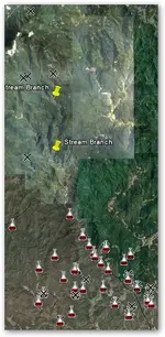
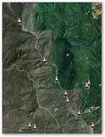
Does the Stream in the picture look like a good spot to you? The red/white flasks are locations with high gold content in stream, soil and rock sediment. Upstream from the pic is a Federal Forest.
 

Attachments

  • NC-GOLD.webp
    NC-GOLD.webp
    54.1 KB · Views: 925
Upvote 0
TAKODA said:
Your kidd'in .. right ?

I know it's a good spot. It's actually better than it looks in that pic. There are five old mines to the north (1960's) with streams below the mines that connect and multiple old placer claims to the south.

In this pic, the X's are old mines, the yellow pins are where the streams meet.

I'm stuck in Florida and dont know when I can get there to check it out!
 

Attachments

  • nc-stream-2.webp
    nc-stream-2.webp
    48.3 KB · Views: 874
how did you get the layers for the flasks and crosses?
 

You get them from the USGS. Select what info you want, select the State or County, download the google earth file and open it in google earth.

http://tin.er.usgs.gov/
 

Nick,
love the pics, but I was trying to do the same as you with an area I'm interested in and couldn't figure it out. Could give please give a little more instruction on how to do this? Greatly appreciated if you have the time.

Bang
 

Bang,

To get the gold mines go here http://tin.er.usgs.gov/mrds/find-mrds.php Select the location and download the google earth file. These are the black X's.

The others are a bit harder. Go here http://tin.er.usgs.gov/ Select the info you want, stream sediment, rock samples, ect. You have to do each seperately. These are the red/white flasks. You need to download both the CVS files and the google earth files.

Open the cvs file and search for AU to see the Parts Per Million (PPM). Most will say -01. The others are the ones you want, the positive numbers. You need to input the latitute/longitute info into google earth or open the google earth file (soil/streamsedement, ect whichever is the same as the cvs file) and click off the box (in google earth) next to the file # shown in thwe cvs file.

It's harder to explain than to do!

good luck!

Nick
 

Nick i can see a few places that i would pan the hell out of even if there had never been any pm's found in the area before.

couple of spots look like they need me LMAO
 

Hi Nick. I woud cross check your spots here : http://www.geocommunicator.gov/blmMap/Map.jsp?MAP=MC and check for current claims. Any updates on this? Can you explain a little further how you got to the flasks? I read what you posted and followed your link only to get lost looking for stream sediment. Thanks. :icon_thumright:
 

#1-what state,you'd be better served with a state geology map showing,faults,dikes,contact points,old workings,and much other data to make a real attempt at what your trying to achieve here. You are going to have to trust someone with info to do the footwork. With no dredging in kalif and the forest circus and blm now requiring NOI/POO it's purt' near impossible to have a real working op going on now. Your DEEP wallet is the only real consideration. Your really a ways from the action and a summer fun run in the sun is the answer. There are plenty of guys,clubs and public areas to work without the cash $$$$$$ outlay--but the hunt is always fun-tons a au 2 u 2 -John
 

Looks to me as a claim on ebay in idaho................I'm I right??.......just saw it the other day........be careful........... :dontknow:
 

Jack Hamilton said:
Hi Nick. I woud cross check your spots here : http://www.geocommunicator.gov/blmMap/Map.jsp?MAP=MC and check for current claims. Any updates on this? Can you explain a little further how you got to the flasks? I read what you posted and followed your link only to get lost looking for stream sediment. Thanks. :icon_thumright:

Jack,

This is the link for stream sediments...

http://tin.er.usgs.gov/nure/sediment/

Then click... "Download data for geographic areas you choose" to select the State, County that you want to research.

I download both the cvs files and the google earth files for each location.

The cvs files are text files but you should open them in a spreadsheet program such as Microsoft Works Spreadsheet included with windows.

Then I sort the AU column decending to show the highest ppm of gold on top. Click "Tools" . "Sort" Make sure you also select "The selected cells and all the cells to the left and right" Once you have the highest PPM decending go to Column A, the REC_NO. Open the google earth file and check off the number shown under REC_NO and the flask will mark the spot. If you do not have google earth then just copy/paste the long/lat of the location into google maps. Again, the flask will mark the location.

The post above by Hoser talks about geology maps with fault lines and other features. You can download them for the same regons you choose at...

http://tin.er.usgs.gov/geology/state/ These require google earth and take forever to load!

For soil and rock info go to...
http://tin.er.usgs.gov/ngdb/rock/select.php

To hard for me to explain but I'm sure you can figure it out.

Here is an example of what info is given. Click the link below and then click google maps to see the location. This place looks like someone living in a trailer with 10ppm gold in his back yard. Probably doesn't even know it!

http://tin.er.usgs.gov/ngdb/rock/show.php?place=fUS37
 

hard rider said:
Looks to me as a claim on ebay in idaho................I'm I right??.......just saw it the other day........be careful........... :dontknow:

Not Idaho. It is NC.
 

A search for North Carolina reveals less than 10 locations with >=10 ppm. This data is almost 40 years old.
 

Thanks Nick and others that explane how to use the resources that are out there. I love to learn about things but the short cut threw the learning curve sure makes it stick much better. Thanks
 

Top Member Reactions

Users who are viewing this thread

Latest Discussions

Back
Top Bottom