West Penn Twp. history Expert needed

jeff of pa

Super Moderator
⛭ Moderator
🥇 Charter Member
Joined
Dec 19, 2003
Messages
89,998
Reaction score
65,597
Golden Thread
2
🥇 Banner finds
1
🏆 Honorable Mentions:
1
Primary Interest:
All Treasure Hunting
or at least somone who Knows this Schuylkill county Township Well

Jeff741972 ?

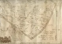
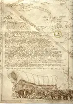
This area Highlighted is just North east of Fort Franklin.
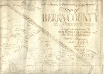
DISTRICT #4
most likely in the area of the Historical Sign on 309.


!!!!GROVEschuylkill_outside_gis-apps32683436279470.webp

Just behind the Small Highlighted Square is this

!!!!CW008036.webp
!!!!Zoomschuylkill_outside_gis-apps32683428279674.webp
!!!!Zoomedschuylkill_outside_gis-apps32683436279663.webp

This large highlighted property has been in the same Family since 1935

It now appears to be owned by 2 Brothers.

One Living in Lehighton
and one Living in Harrisburg

The Small Highlighted Block

!!!!Aschuylkill_outside_gis-apps32683428279571.webp

looks like this

!!!!CW008035.webp

& May be a Pull off that once had a Picnic Table for Motorists.

Was Owned by PA DEPT HIGHWAYS
until 11/25/1986 when the Family who owned the
Above Piece of land Purchased it
from the PA DEPT HIGHWAYS.

The other Small box looks like this

!!!!CW008034.webp

Has a home on it that was built in 1972

!!28888-0.webp

& I'm guessing replacing a earlier home as it has traded hands
several times before 72


What can anyone from the area Tell me about what appears to be the Very Large Grove ?

Even if recently Built it is only about 1900 Feet N.E. from where
I Believe Fort Franklin actually Stood.

!111111111111111111a.webp
 

Can't help you out to much other than saying Ive definitely driven by there. I'd be game if you want to shoot out some time. That's not to far from my neck of the woods.

Brian
 

baspinall said:
Can't help you out to much other than saying Ive definitely driven by there. I'd be game if you want to shoot out some time. That's not to far from my neck of the woods.

Brian

At the rate the weather is going downhill it will probably be spring.

Once it gets Close i'll see if I can get ahold of one of the Brothers

For Permission. Will let you know.

Who knows Maybe because of the Below
normal temps now Next month may go above,
& we can try sooner.
 

I was thinking the fort was more towards where bolich and blue mtn came together, I dont know though for sure. That grove I have no idea about, but put me on the list for checkin it out! BTW tomorrow afternoon I will try and find that school house by zion stone church, I am almost kinda thinking the road now lays opn it when the redid cemetery rd.
 

jeff741972 said:
I was thinking the fort was more towards where bolich and blue mtn came together, I dont know though for sure. That grove I have no idea about, but put me on the list for checkin it out! BTW tomorrow afternoon I will try and find that school house by zion stone church, I am almost kinda thinking the road now lays opn it when the redid cemetery rd.

Yes I forgot about my Latest research on Fort Halifax,
& The Improved Arials on the tax site.

I now believe the fort is fruther south on the Yaggie Property.

He would not allow the archies to dig
whether he would allow Us considering we don't make
trenches or steal land under the Guize of Protecting
it for Future Generations to
look at but don't touch, I Don't know.


If you go by Frontier forts
it's right in Here
where the Red arrow Points


!!!!!!!!!!!!!1111111111.webp
!!!!!!3_.webp
!!!!!!2_.webp
!!!!!!1_.webp


I take it You have no snow ?

Everything is white here in Western Schuylkill County
Good Luck Tomorrow

as for the grove your on the list

for either Spring or Pre-spring if we get one
Long enough to Gain Permission & the ground to thaw.

I won't try for permission till I can give him a starting Date
 

Attachments

  • !!!!!!!!!!!!!1111111111.webp
    !!!!!!!!!!!!!1111111111.webp
    16.3 KB · Views: 294
Thats how I found it on the frontier forts site, That probably would be pretty cool to detect that. From my understanding though that fort wasnt used very much, and then the troops where brought back over the mountain to fort everett? I think thats what its called. I definately want to try for the school house, It should be around 40 tomorrow, and no theres nothing laying on the ground here, but the puddles are froze. In the AM Im gonna look at the soybeans again, just in case he did something this week but I doubt it.

Oh yeah I am probably more of an expert on carbon county, but I always have my eyes open now that I live up here. This next season I hope is gonna kick some butt, I did get an xlt now and re did some ground at my gf's sisters place, needless to say it was a very successful hour in the back yard, bunch of wheats back to 1912 a merc and a buffalo nickle, and not 1 memorial cent! all at 4" or better. ;D
 

Cool on the XLT awsome detector from what i Hear.

!0schuylkill_outside_gis-apps32683428319182.webp

Fort was about Square about 40 Feet,

How long would the sides be to be 40 foot Square ?
I'm terrible at Math
40 X 40 X 40 X 40 ?

There is a hint of that here

!1index.webp
 

Its amazing reading stuff like that a knowing where the forts, the gnaden hutten massacre and all had happened at.
 

Google book search:

Fort Franklin. After the massacre at Gnadenhutten Franklin
built Fort Allen at what is now Weissport. When that was completed
he sent Foulk to build another between it and Lebanon.
It was named in honor of Franklin. It was about forty feet square
with two log houses at the opposite corners. It was also called
Fort Allemangael, or Albany. This fort stood in Schuylkill County
north of Albany Township.
A block house and several other buildings stood on the road
between Fort Franklin and Fort Allen in which soldiers and provisions,
visions, no doubt, were stationed. One of the men in charge of
these forts made trips from one to the other several times a week.
Great excitement prevailed in the entire province after the surrender
of General Braddock. The forts were but feeble preparations
for defense. The people lived far apart and were not prepared to
defend themselves or the forts. The settlers knew their weakness
but too well. Many staid in their homes and trembled with fear while
many more fled.


And another:

From 1744 till 1778, when the Indians were finally
driven from the region, and especially between 1744 and
1764, the inhabitants of Berks suffered much from the
incursions of marauding bands of these savages, who
came oftenest from the direction of the Blue mountain.
To protect themselves against these the inhabitants constructed
forts along the Blue mountain at a distance of
fifteen or twenty miles from each other, so that rangers
from one could easily reach the other by a march of a
day.
One of these, which is known as Fort Franklin, was
erected in 1756 on Lizard creek, an affluent of the Le-
high. Fort Lebanon, otherwise called Fort Bohundy or
Fort William, was built in 1754 on a branch of the
Schuylkill. Both these were north from the Blue mountain
chain, in what is now Schuylkill county. A stockade
called Fort at Snyders was on the present line between
Berks and Schuylkill counties, west from Schuylkill
river; another, named Sichtes or Sixes fort, was south
of the Blue mountain, in the western part of Berks; and
still another, Fort Henry, south from the mountain
chain, on an affluent of Swatara creek, in Lebanon
county. Traces of some of these forts are still discernible.
 

I should know better than to try and give you info... ;D (still trying to catch up)
Here I am, an armchair researcher and you have all the info already.

Looks like a lot of good history there.
 

jeff of pa said:
jeff741972 said:
I was thinking the fort was more towards where bolich and blue mtn came together, I dont know though for sure. That grove I have no idea about, but put me on the list for checkin it out! BTW tomorrow afternoon I will try and find that school house by zion stone church, I am almost kinda thinking the road now lays opn it when the redid cemetery rd.

Yes I Corrected it.

I forgot about my Latest research on Fort Halifax,
& The Improved Arials on the tax site.

I now believe the fort is fruther south on the Yaggie Property.

Hi predecessor
would not allow the archies to dig
whether the new owner would allow I Don't know.


If you go by Frontier forts
it's right in Here
where the Red arrow Points


I take it You have no snow ?

Everything is white here in Western Schuylkill County
Good Luck Tomorrow

as for the grove your on the list

for either Spring or Pre-spring if we get one
Long enough to Gain Permission & the ground to thaw.

I won't try for permission till I can give him a starting Date
 

JG_in_NC said:
Google book search:

Fort Franklin. After the massacre at Gnadenhutten Franklin
built Fort Allen at what is now Weissport. When that was completed
he sent Foulk to build another between it and Lebanon.
It was named in honor of Franklin. It was about forty feet square
with two log houses at the opposite corners. It was also called
Fort Allemangael, or Albany. This fort stood in Schuylkill County
north of Albany Township.
A block house and several other buildings stood on the road
between Fort Franklin and Fort Allen in which soldiers and provisions,
visions, no doubt, were stationed. One of the men in charge of
these forts made trips from one to the other several times a week.
Great excitement prevailed in the entire province after the surrender
of General Braddock. The forts were but feeble preparations
for defense. The people lived far apart and were not prepared to
defend themselves or the forts. The settlers knew their weakness
but too well. Many staid in their homes and trembled with fear while
many more fled.


And another:

From 1744 till 1778, when the Indians were finally
driven from the region, and especially between 1744 and
1764, the inhabitants of Berks suffered much from the
incursions of marauding bands of these savages, who
came oftenest from the direction of the Blue mountain.
To protect themselves against these the inhabitants constructed
forts along the Blue mountain at a distance of
fifteen or twenty miles from each other, so that rangers
from one could easily reach the other by a march of a
day.
One of these, which is known as Fort Franklin, was
erected in 1756 on Lizard creek, an affluent of the Le-
high. Fort Lebanon, otherwise called Fort Bohundy or
Fort William, was built in 1754 on a branch of the
Schuylkill. Both these were north from the Blue mountain
chain, in what is now Schuylkill county. A stockade
called Fort at Snyders was on the present line between
Berks and Schuylkill counties, west from Schuylkill
river; another, named Sichtes or Sixes fort, was south
of the Blue mountain, in the western part of Berks; and
still another, Fort Henry, south from the mountain
chain, on an affluent of Swatara creek, in Lebanon
county. Traces of some of these forts are still discernible.

Thanks for posting !

Not sure what Source you used, but
A couple additions & corrections

"Fort at Snyders" not realy an error

but was also known as "Fort Dietrich Snyder"
Yes it did sit on top of the Blue Mountain
& was a settlers house converted
into a makeshift fort.
Because of it's view it was used to send signals
from one side of the mountain to the other.

This is the only Photo I can find from approximately 1900

FORT DIETRICK SNYDER.gif

another, named Sichtes or Sixes fort, was south
of the Blue mountain, in the western part of Berks; and
still another, Fort Henry, south from the mountain
chain,


Sichtes ? Never heard it called that.
must have been a Misspelling in someones
report back then. common happening in the 1750's
But Was
All the same Fort

Sixes fort was "Fort Henry" & was built on the farm of
Dietrich Six & somtimes referred to as six's

It was the Most Important fort along the Mountain Chain
& stood Between Pine Grove In schuylkill County
& Bethel in Berks County almost
at the base of the Blue Mountain on the Berks side
 

Jeff, you probably posted this before but just in case it was not, here is another partial map showing Ft Henry.

Don
 

Attachments

  • BerksMap1776View4sm.webp
    BerksMap1776View4sm.webp
    478.6 KB · Views: 280
Don in SJ said:
Jeff, you probably posted this before but just in case it was not, here is another partial map showing Ft Henry.

Don

No I havn't Don
I have read of this Map in many local Histories
But never seen a Readable Copy.

The Grove of pines in the N.W. Corner are in Northumberland County
in Eardman behind De Eck or at least was & Is where Pine Grove Twp got it's name

!!_DE_ECK.webp

Shamokin is actually Fort AUGUSTA in Sunbury (Formerly Shamokin)

Brown should be on 895 heading towards west Penn twp

Gunkles & The Eagle Tavern were in Pine Grove. Schuylkill County

roeders was along the south side of Broad Mountain

My House would be somewhere along & accross the Tulpehocken Path
from Reiths although.

I have never heard of Reith's

I have never heard of Bressler or Gressler either there is no mention of them anywhere
 

Here is more of that map, I reposted the same map above with more clarity (I think) :)

Don
 

Attachments

  • BerksMap1776View2red.webp
    BerksMap1776View2red.webp
    359.8 KB · Views: 265
  • BerksMap1776View3red.webp
    BerksMap1776View3red.webp
    251.4 KB · Views: 221
  • BerksMap1776View4red.webp
    BerksMap1776View4red.webp
    418.8 KB · Views: 225

Top Member Reactions

Users who are viewing this thread

Back
Top Bottom