What does this Old Concrete Marker Signify?

jml818

Full Member
Joined
Sep 26, 2016
Messages
118
Reaction score
459
Golden Thread
0
Location
Philadelphia, Pa
Detector(s) used
Garrett AT max
Primary Interest:
All Treasure Hunting
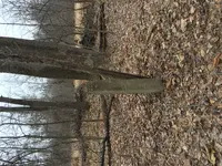
I have found many old coins, large cents date range 1814-1850, in vicinity of this old concrete post in the middle of the woods. I'm thinking maybe an old homestead was nearby? Is it a boundary marker?
Sort of looks like one of those old highway mile markers with sloped top, but I don't know.
 

Attachments

  • Marker.webp
    Marker.webp
    1.9 MB · Views: 236
Upvote 1
This website seems to have ALL the bells and whistles to surf and post articles, but why does it upload pictures in reverse? AND that's ok, BUT why after you upload these attachments does this website not have an orientation button to correct and save the photo??
Sorry, about the sideway shot but my picture states my case.
Would still love an answer as to what these markers represent, just turn your head 90 Degrees to left,, ha ha.
 

Thanks Stealthycat!!! Great link
 

My photo always upload correctly.. not sure why it's happening. Maybe the position your camera was in when u took it?
 

This website seems to have ALL the bells and whistles to surf and post articles, but why does it upload pictures in reverse? AND that's ok, BUT why after you upload these attachments does this website not have an orientation button to correct and save the photo??
Sorry, about the sideway shot but my picture states my case.
Would still love an answer as to what these markers represent, just turn your head 90 Degrees to left,, ha ha.
Hey, jml818. I've been having the same trouble with rotated images. I solved the problem by deleting the image, rotating it, crop it, and then re-inserting it. It should then have the proper orientation.:icon_thumright:
 

It could be a section line corner marker.
 

the old O.C. Barber Mansion in Barberton Ohio was built around 1890-1910 until it was torn down in the mid 60's... they used those as fence posts and corner marker stones within his farm. To separate the hog pens from the cattle yard and any other boundary within the farm enclosed is a photo of the hog barn with fenced in area. can you say OVER KILL for the porkers..oc barber.webp
 

That's one of my detecting markers - thought it looked familiar.

Anything found within a 50 yard radius goes to me :)
 

the old O.C. Barber Mansion in Barberton Ohio was built around 1890-1910 until it was torn down in the mid 60's... they used those as fence posts and corner marker stones within his farm. To separate the hog pens from the cattle yard and any other boundary within the farm enclosed is a photo of the hog barn with fenced in area. can you say OVER KILL for the porkers..View attachment 1415323


Is that a family residence? If so, that's even more in-your-face than Hollywood/Beverly Hills. wow
 

Has anyone here seen the USGS Topo maps showing where the physical reference markers are in the ground?

I ran across a brass/bronze USGS marker set into a concrete abandoned rail road trestle embankment wall. When I got home, I looked at a USGS map, and sure enough, it gave a symbol on the map, showing where it was, and it's precise elevation there.
 

Is that a family residence? If so, that's even more in-your-face than Hollywood/Beverly Hills. wow

Nope thats a hog barn they had chicken coops nearly that big, and a mushroom barn just to grow them indoors.... he started a match company that produced the old 'farmer matches' .... interesting read and photos if you check him out.. his daughter owned the "Anna Dean farm" which also was a real sight to see!!
 

That's one of my detecting markers - thought it looked familiar.

Anything found within a 50 yard radius goes to me :)

Chicago is a long hike from this little patch of woods, outside Philadelphia.
 

Cant tell from photo but link is awesome!
 

Top Member Reactions

Users who are viewing this thread

Latest Discussions

Back
Top Bottom