Whats the odds?

Arrowheadhunter

Jr. Member
Joined
Feb 27, 2013
Messages
45
Reaction score
14
Golden Thread
0
Primary Interest:
All Treasure Hunting
If you're willing to do a little research, your chances are great. Old maps and books will lead you right to the places.
 

What's the odds?

Thanks for the link! Great crossings is just a little outside of Georgetown. Turkeyfoot is not in the first pic you posted. Thanks again
 

Do you have an idea of where Turkeyfoot was? If so, you're good to go. The names change, the buildings stay the same. Chances are, most of the buildings in the late 1800's were still standing when that map was made....
 

What's the odds?

Yes I know where the modern church of Turkeyfoot was built in the late 1800's . It wasn't like a small town and have a main street. The creeks they talk about involve several miles of creek banks. I know exactly where it forms the turkeys foot but the information is very vague.
 

What's the odds?

I found a publication on Scott county surveys from 1792-1834 but you have to go to a historian club in Louisville to view it.
 

I reread the link that you posted and I understand the situation a little better. You're looking for buildings of the 1790's-early 1800's I think. Those does pose some issues. Since Turkey Foot was a "area" instead of a town, you'll be hard pressed to find a map that's time appropriate. The survey that you mention may be a geological or other type survey, those were pretty common back then. And you have miles of land that comprise the Turkey Foot area so it will be hard to pin point a particular mill or general store. Those type places are best found by talking to the old timers. I researched Peak's Mill a couple years ago. There's not a building standing today in that area. I lucked into a history journal that had a hand drawn map of the town. It's a blind draw but the convergence of the creeks is were I would start. Those pioneers were fond of water ways. Some of the mills had to be located on water. Any flat spot at or above creek level would be a good spot. If you and your coil cover enough ground, you'll find one of those places, guaranteed.
 

OK, now I see why Turkey Foot isn't on map link I gave you....lol....back to the drawing board......
 

Last edited:
What's the odds?

Thanks that's a nice map!
 

What's the odds?

Where do you get these. Maps?
 

What's the odds?

I meet with a distant relative that lives in the area and he gave me a copy of Beers and Lanagan 1879 map of Scott county. I hope I can find something. The first spot I checked had no current house on it but had some recently and was full of junk. I'm going out tomorrow to some more remote locations.
 

What's the odds?

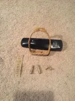
Not bad, nothing valuable yet. Some gun shells, not that old, and an unidentified mangled metal. A ladies side saddle stirrup and a harmonica reed. All found at pre 1900 log cabin sites.
 

What's the odds?

ImageUploadedByTapatalk1362963685.675244.webp
 

Nice finds! You're onto to something there now. Hard to beat a Beers and Lanigan map, they are the very best. Does the Turkey Foot area show up on it?
 

What's the odds?

Yes and has many old home sites. My second cousin that's a genealogist by hobby in his retirement showed me where the salon was and general store. The salon site has a modern house on it.
 

Top Member Reactions

Users who are viewing this thread

Latest Discussions

Back
Top Bottom