I live in the circled area. Of course, now it's called "Columbus, Ohio" but who really knows what it'll be called in another 200 years?
By the way, I've been asked a few times where I obtained this map.
Most of the best old maps come from the Library of Congress'
American Memory Map Collections.
You can find it at
http://lcweb2.loc.gov/ammem/gmdhtml/gmdhome.html
You can view the maps online with their special viewer that allows you to zoom in and pan around the map, but the best way to view the (by far) is to download the maps themselves, and use the MrSID viewer application
http://memory.loc.gov/ammem/help/download_sid.html to view them. It's much faster and you'll be able to export certain sections of the maps.
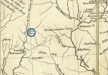
Most of the maps they have are very large and detailed. The particular map I used below is the
Hutchins' Topographical Description (1778) [5044000] and it is probably 45" x 35" in size if you could actually print it, which means the level of detail is astounding. With the MrSID viewer, you can view the whole thing or zoom into very small places.
Let me know if you have any trouble finding what you need or have questions.


") ? ? 50 miles north of Tulsa, 16 miles south of the Kansas/Oklahome line
? ? 50 miles north of Tulsa, 16 miles south of the Kansas/Oklahome line