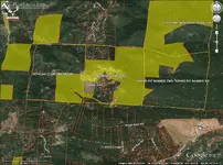
Unfortunately guys before you head out there.... That whole area your are talking about ~ is claimed and unless you work out a % deal with the claim owner it is off limits to detecting & prospectors .(owner listed below)
The map attached > yellow= US Government & inside red lines > = Private Property.
Map photo is available here at
MineCache.com - Home - Gold Prospecting with Google Earth
The latest claim listings and the property ownership is
onXmaps
I found it is always nice to avoid ugly issues knowing that where you are going isn't going to end up with some pissed~off property owner or claim owner pointing a deer rifle at you!!!!!
Plan ahead and it is very important to do your home work! > Happy Hunting... Life is good!
GoldGPX

ROTSAROCKS : ACTIVE CLAIM
Serial Number: CAMC306233
Claim Status: ACTIVE
Claim Type: PLACER
Claimant: FAIRHURST JEFFERY T
Date Located: 12/05/2012
Date Closed:
State: CA
County: PLACER
Meridian: 21
Township: 0140N
Range: 0100E
Section: 028
Sub Division: NE
JEFFREY T FAIRHURST =CLAIMANT
495 N MAIN ST LAKEPORT, CA 95453-480
------------------------------
SNOB HILL : ACTIVE CLAIM
Serial Number: CAMC277768
Claim Status: ACTIVE
Claim Type: PLACER
Claimant: MILLER CINDY
Date Located: 09/01/2000
Date Closed:
State: CA
County: PLACER
Meridian: 21
Township: 0140N
Range: 0100E
Section: 028
Sub Division: NW


 I wonder if I could access maps like that from my phone...
