The Peralta Stone Maps, Real Maps to Lost Gold Mines or Cruel Hoax?

Do you think the Peralta stone maps are genuine, or fake?


  • Total voters
    121

Ellie Baba

Hero Member
Mar 7, 2005
527
54
Laveen, AZ
Detector(s) used
Tesoro Lobo
Peralta Stone Maps and Ellie Baba's soon to be released book

jimb:

I happen to agree,although some of the Stones on display may only be reasonably accurate copies of the original set.
But what is it that makes YOU so sure ?
What do they lead to ?
And who do you think were responsible ?

Regards:SH.

Hi SH,

Sometime in the near future I will be releasing copies of my new book: The Peralta Stone Maps; the Horse Map. I have completed 6 chapters of 8 and it will initially sell as an e-book.

This book will answer the questions listed above and many more. The Horse Map is addressed in Volume 1 and the other stone maps will be addressed in volumes 2 and 3.

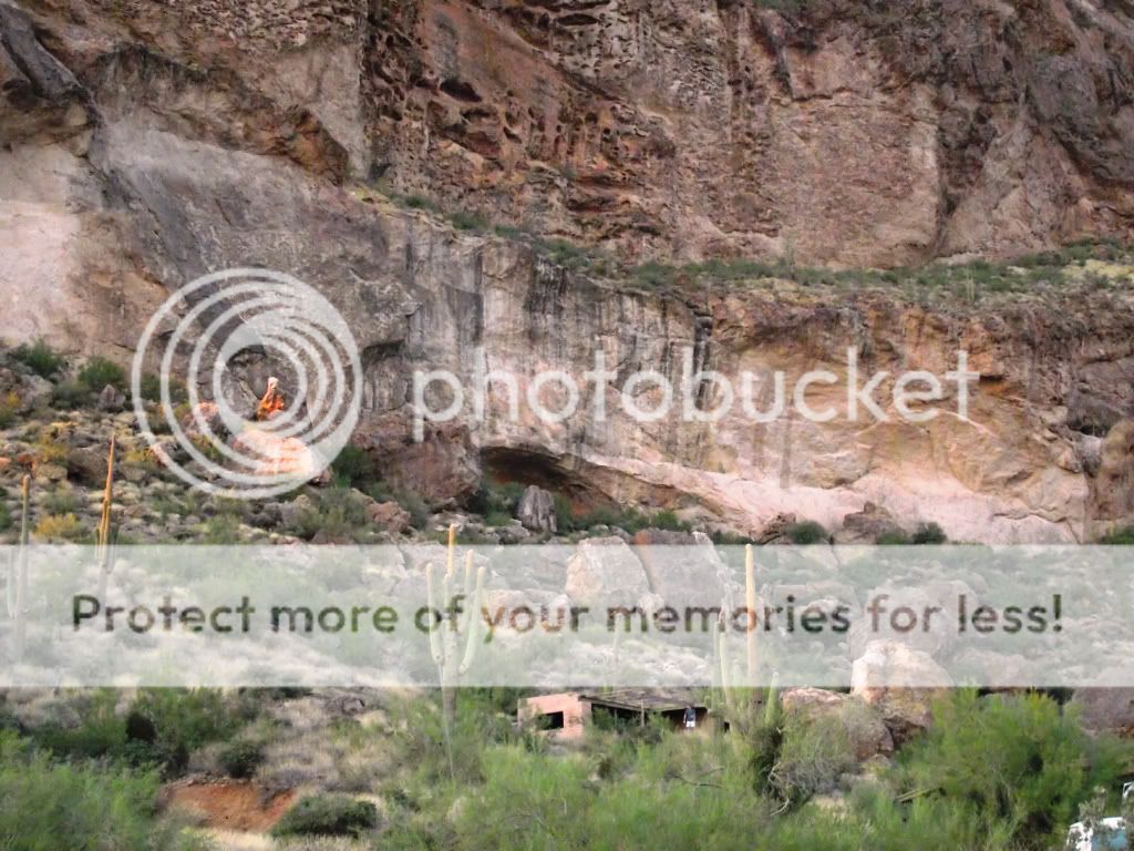
The Horse Map directs us to an exact location in the depository area that will place us next to a massive rock out cropping (the fourth so-called missing stone map) that provides

crucial information that is not mentioned anywhere on the Horse map or any of the other stone maps. The book has been reviewed by a select group of our peers to include

a number of non-believers who have admitted that the evidence submitted in this work are factual and quite convincing. Having spent the last 20 plus years of my life putting all of this

information together has paid off and I for one am quite satisfied with my efforts and truly thank those who have assisted me thru the years. There will be those who may disagree with

my findings, but will find it hard to provide any evidence to the contrary. Two and one = 3 no matter how you look at it (although some would even argue that the correct answer is incorrect).

Such is life my friend, and I will see you at the next Rendezvous if not before. Have a great week!

Ellie Baba
 

somehiker

Silver Member
May 1, 2007
4,365
6,426
Primary Interest:
All Treasure Hunting
EB:

I for one,will be looking forward to your E-book.
As questions still remain unanswered.
But the map on the Horse Stone is a good place to start.
Keep us posted.

Regards:SH.
 

Last edited:

skumpa

Jr. Member
Mar 7, 2012
52
2
Primary Interest:
Metal Detecting
I don't get it. With over 400 mexicans, horses, and mules, camps, waste temporay housing, corrals, tailing, ect...... and that's one group. How could nobody find these mines? Shouldn't there be mass travel paths? I know it's been awhile since all this happened. But they're doing better in egypt finding lost tombs thousands of years old.

Scott
 

peralta

Sr. Member
Sep 28, 2011
389
45
oahu hawaii
Detector(s) used
Whites 2-box
Primary Interest:
All Treasure Hunting
Good luck on book ellie baba. But everything you state is assumptions. The horse isn't the the main treasure spot .
Scumpa, they prepared the mines, which took years to hide it from the world.I have checked every part of the peralta treasure areas and you would never know that minors were ever in the area.I can't write my book till I finish taking out the treasures.
 

skumpa

Jr. Member
Mar 7, 2012
52
2
Primary Interest:
Metal Detecting
Good luck on book ellie baba. But everything you state is assumptions. The horse isn't the the main treasure spot .
Scumpa, they prepared the mines, which took years to hide it from the world.I have checked every part of the peralta treasure areas and you would never know that minors were ever in the area.I can't write my book till I finish taking out the treasures.


Need help?
 

Ellie Baba

Hero Member
Mar 7, 2005
527
54
Laveen, AZ
Detector(s) used
Tesoro Lobo
EBB (ellie baba book)

Good luck on book ellie baba. But everything you state is assumptions. The horse isn't the the main treasure spot .
Scumpa, they prepared the mines, which took years to hide it from the world.I have checked every part of the peralta treasure areas and you would never know that minors were ever in the area.I can't write my book till I finish taking out the treasures.

Thank-you, Peralta,

The horse acts as our guide and he directs us to the primary locations to find the answers written in stone (just like the stone maps). The information located in each primary area will direct us to each cache location.

The caches are not marked with an "X" or with any other symbol or sign. These caches are extremely difficult to locate and the only way (other than using some state of the art scientific equipment) to find them is to

decipher the the clues written on the ciffs, outcrops and mountains (the Mountains covered with symbols). Somehiker; You know what I am saying? The longer that someone travels the main trails in the depository area

and pays attention to detail will learn what I have learned. Look for that which has been hidden and seek the counsel of wisdom once it has been found.

I have some pics to post if I can figure out why I cannot get them uploaded. These photographs will help those of you who are trying to see the un-seen. One Amazing photograph was taken right next to the cliff that

we could see, but did not see. The location? Dons Camp where we hold our annual Rendevouse. I call it "Big Head".

Have a great week!

Ellie Baba
 

cactusjumper

Gold Member
Dec 10, 2005
7,754
5,388
Arizona
Hi Ellie,

we could see, but did not see. The location? Dons Camp where we hold our annual Rendevouse. I call it "Big Head".

Perhaps you should consider Peralta or even Skumpa!:dontknow:

Take care,

Joe
 

somehiker

Silver Member
May 1, 2007
4,365
6,426
Primary Interest:
All Treasure Hunting
EB:

Easiest way to post your pics,is to open a Photobucket account.
Dump your photos into an album.
Then open the album,select your pic and copy and paste the bottom link under the photo (img code) into your post on here.

The only big head that's important is that of the Priest.
As important as the Priest himself,and where he stands.
And what he's telling us about the caches.
This is his shoulder/upper arm with part of the cross and the end of the sleeve visible.

100_0749priestcrop.png


Regards:SH
 

somehiker

Silver Member
May 1, 2007
4,365
6,426
Primary Interest:
All Treasure Hunting
And this lies prominently just below and forward of the Priest.

100_1088priestcrop.png
 

Ellie Baba

Hero Member
Mar 7, 2005
527
54
Laveen, AZ
Detector(s) used
Tesoro Lobo
"Bighead" cliff mural at Don's Camp

DA_Bighead-rondez2010AC.jpg


Read and understand the following information carefully;

Just left of center you will see an orange looking being standing on the top of a grey and orange rock. Bighead's jaw and open mouth are directly to the right of the orange being. There is a small group of people standing inside his open mouth. I realize that that identifying these art forms are difficult to comprehend. Every square centimeter of this photograph has something inscribed by the hands of men. You may have to spend many hours just to study this mural to become familiar with the techniques used to create these art forms. A man is standing to a sloping of roof attached to a building, just above and to the left you will see a small boulder (with a hole in it) sitting between to large boulders. The boulder on the left depicts a face looking towards the orange being; note the back of the head/hair region inside the rectangular area. Notice the Anglicized letters written in lines. There are numbers, letters, crosses, skulls, and people all over this photograph. If you can recognize these art forms you will be able to recognize the sara (shadow animated rock art) connected to the Peralta Stone Maps. Bighead was created by the same group of people that are tied to the Peralta Stone Maps! The only difference is they have been separated by centuries. This information is hard to swallow and believe me there was a time when I thought I was going nuts. I decided to post this information here because most of you believe the stone maps to be the real thing and those of you who will put forth the effort to study this photograph and the many other photographs forthcoming will reap the benefits of knowing the truth. This is ojt (on the job training) my friends if you want to see the unseen.


If you do not understand ask questions. Any comments or observations email me. There is over 20 years of experience in my head so challenge me and I will answer what I can.

Thanks for the tip SH.

Another beautiful day!

Ellie Baba
 

Last edited:

somehiker

Silver Member
May 1, 2007
4,365
6,426
Primary Interest:
All Treasure Hunting
Boy,that is one evil looking face.
A few more cups of Clay's sippin whiskey,and I'd be ready to start drilling holes for dynamite.
Love the orange alien....kinda thought we had a few at the rendezvous last year,but I didn't want to say anything and risk getting my butt fried.
Don't know if I'd put much faith on anything round about the Don's Camp,though.
Too many twisted tricksters in the neighbourhood.
Could be a self portrait of one of them.

Regards:SH
 

Ellie Baba

Hero Member
Mar 7, 2005
527
54
Laveen, AZ
Detector(s) used
Tesoro Lobo
Boy,that is one evil looking face.
A few more cups of Clay's sippin whiskey,and I'd be ready to start drilling holes for dynamite.
Love the orange alien....kinda thought we had a few at the rendezvous last year,but I didn't want to say anything and risk getting my butt fried.
Don't know if I'd put much faith on anything round about the Don's Camp,though.
Too many twisted tricksters in the neighbourhood.
Could be a self portrait of one of them.

Regards:SH

Hi SH,

The only reason that the alien dude is orange is because the photograph was taken at sunset. Note the orange reflection on the saguaros. Any other time of the day one would not notice the alien at all except for some

subtle clues. Thousands of people have attended numerous events at the Don Camp throughout the years and far as I know no one has ever seen this mural. I have asked people who have been at the Rendevous for the

last two years what do they see when looking at the cliff? Not a dang thing. You would not put much faith on anything around the Don's Camp... this is just the place to look for a clue. Whoever decided originally to place

the Don's Camp at this location knew something that we did not know. They left this message in plain sight for all to see. So, what should we expect to find within this mural? An important clue or an important message

relating to the Stone Maps or?


What needs to take place next is patience and alot of work. The above photograph was taken outside of the viewing corridor, but due to the rock heads angle one could assume the viewing corridor matches that angle.

By setting up a camera (mark all locations) at a number of different angles, besides the rock heads angle, and study all of the photos taken at the different time intervals (8:00 AM, 12:00 PM, 2:00 PM and so on) one

day a week over a six month period of time. After reviewing these photographs that have been collected during this time frame the exact message or clue should be very apparant.

There are clues hidden in the most remote areas of the depository area and they will only be found if you go in on foot or horseback. You people who think the only way to go is by using Google Earth have it all wrong,

even the baloon theory is good for a great laugh (sorry, don't want to hurt any feelings). How could anyone see this mural by using Google Earth or by flying over in a baloon? Every pertinent clue is missed and the

treasure(s) will not be found until all of the clues are located and understood 100%.


One of the clues that I will point out in my upcoming book relates to an exact position marked exactly at 36" (that is 36 seconds) of longitude. Anyone know the exact distance the sun must travel along the 33rd latitude

for 36"? The Stone Maps do not allow for any type of error... period!

I have friends and acquaintances that I use to garner knowledge and the reason for this is quite simple. It would take me 10 lifetimes to amass enough knowledge to figure out how to solve these Stone Maps! However,

once you realize how something works and you understand how its workings accomplish a specific task a light comes on in your brain... wow, that was easy.

Have a great weekend,

Ellie Baba
 

Last edited:

skumpa

Jr. Member
Mar 7, 2012
52
2
Primary Interest:
Metal Detecting
Hi,
I know people don't like using or depending on google earth, but compare these pics please. GoogleEarth_Image.jpg dutchman map A.gif

Now what if the el somboro is the weevers needle and the s. sima is the miners needle, the reason for the drawing of these to are markers only, because of the distance between them? Now people have said that the N is actually E. that would put the ge pic in the right spot. The trail leading to the mine seems to also correct. Remember to be nice and don't tell me I'm full of s$#^.
Scott Wellman
 

Ellie Baba

Hero Member
Mar 7, 2005
527
54
Laveen, AZ
Detector(s) used
Tesoro Lobo
Hi,
I know people don't like using or depending on google earth, but compare these pics please. View attachment 628941 View attachment 628942

Now what if the el somboro is the weevers needle and the s. sima is the miners needle, the reason for the drawing of these to are markers only, because of the distance between them? Now people have said that the N is actually E. that would put the ge pic in the right spot. The trail leading to the mine seems to also correct. Remember to be nice and don't tell me I'm full of s$#^.
Scott Wellman

Hi Skumpa,

I do in fact use Google Earth for gathering the depository information for it is a very important tool. Latitude, longitude and elevation are important factors. I would be the first to say that you just might have something worth looking into.

I have looked up so many canyons trying to ID this particular spot. So, you must do the same, but you have the advantage (with the ge pic) and know just about where to stand. All you have to do is to put the map into the proper perspective with the

same scene in real life. This will be the true test: If you can provide a photograph of the area that the ge pic represents that matches the drawing on the map you will be the talk of the town. This is where true dedication to the work at hand comes in

to play. This exercise will take you some time and probably will not come together on your first day out, so be ready to invest some time. You may get lucky and find a match, who knows?

Are you in a position to take on this excercise? You must be able to convince yourself that this discovery is 99% correct because you will have to be the one to ultimately prove your theory out... and then YOU will know if you are full of ****!

But first; hide your drawn map where you cannot see it. Now trace or draw the geologic structures that you see on your ge pic and then compare it to the already drawn horizon map. You make the call or better yet post your results here so that

we may be able to assist you with the alignment. You may have to turn clockwise or counter-clockwise to bring the ge pic into focus with the horizon map. Get Hal to help you if he will for it is better to have someone to work with than doing it all by

yourself. Trust me on this one.

Good luck: Never give up, never surrender!

Ellie Baba
 

mullnax

Jr. Member
Apr 10, 2012
27
5
El Paso
Primary Interest:
All Treasure Hunting
wasn't weaver's needle actually named el sombre in the old days. according to some old maps I have it says el sombre. not weaver.
 

mullnax

Jr. Member
Apr 10, 2012
27
5
El Paso
Primary Interest:
All Treasure Hunting
Hi,
I know people don't like using or depending on google earth, but compare these pics please. View attachment 628941 View attachment 628942

Now what if the el somboro is the weevers needle and the s. sima is the miners needle, the reason for the drawing of these to are markers only, because of the distance between them? Now people have said that the N is actually E. that would put the ge pic in the right spot. The trail leading to the mine seems to also correct. Remember to be nice and don't tell me I'm full of s$#^.
Scott Wellman

Weaver's needle used to be called el sombreo. so you are right from the research I have been doing. Here is a map maybe you can link what you have to this old map and I wish you luck. If you want any help let me know. I am taking a trip out there soon well as soon as I can walk again. superstition mountains (851x1024).jpg
 

mullnax

Jr. Member
Apr 10, 2012
27
5
El Paso
Primary Interest:
All Treasure Hunting
imagesCAG1UIPT.jpg imagesCAHH4TS9.jpg imagesCALQ43WK.jpg imagesCAOWG8V4.jpg MillerMap.jpg traifrnt.jpg pclmaps-topo-az-fort_mcdowell-1904.jpg superstition circa 1900 (851x1024).jpg


I am sure everyone has these maps already. I have a few more old military maps and a few old apache maps of the area. Just wondering when looking at the old 1900 super mountain map does anyone have any information about the area around apache gap, millsite canyon. Just trying to get some hiking info about that area. That way I am not going out there totally blind. Also is it normal for most hikers to bring a weapon with them. I want to bring a shotgun as well as my barrett sniper rifle just in case.
 

cactusjumper

Gold Member
Dec 10, 2005
7,754
5,388
Arizona
mullnax,

"I want to bring a shotgun as well as my barrett sniper rifle just in case."

Yah......bring it all, and don't forget a couple of handguns and a bowie knife.

Good luck,

Joe Ribaudo
 

Cubfan64

Silver Member
Feb 13, 2006
2,986
2,789
New Hampshire - USA
Detector(s) used
Fisher CZ21, Teknetics T2 & Minelab Sovereign GT
Primary Interest:
All Treasure Hunting
Also is it normal for most hikers to bring a weapon with them. I want to bring a shotgun as well as my barrett sniper rifle just in case.

Is it normal for the most hikers? I'd say no probably not. Do some hikers carry when hiking out there? Yes, I'm sure they do. In my opinion, the further off trail you go, the more chances you take of running into someone who might not want to be "run into" - be they someone doing something illegal (pot hunting, drugs, etc...) or just someone who'd rather be alone. Carrying a gun isn't a bad idea for safety reasons - animal problems (cats or snakes?) and you can always use it as a signal device if you get lost or need help.

As far as carrying a shotgun and/or Barrett sniper rifle? I guess it's just me, but I don't see the point - I can think of LOTS OF THINGS I'd rather carry that would weigh that amount that would be much more useful. I can't imagine any reason for carrying a sniper rifle out there, but that's just me. A lightweight .357 revolver with a few dozen rounds seems like more than enough.
 

skumpa

Jr. Member
Mar 7, 2012
52
2
Primary Interest:
Metal Detecting
Ellie'

Thanks for your comments. First I believe the author of the map, made it a panoramic view, to include large landmarks. Second, did the author originally place the "head rock" on the small hill? If he did, then again using landmarks from a large area, this is what I found. rock head 1.png Inthe center of this pic, I see the exact rock head on the hill, it is not on that hill but further up the trail, going in.

Thanks

Scott Wellman
 

Top Member Reactions

Users who are viewing this thread

Top