A Heap of Proof.

Status
Not open for further replies.
OP
OP
Hal Croves

Hal Croves

Silver Member
Sep 25, 2010
2,659
2,695
Hal,

"It also supports my ideas about Aylors Arch being an important landmark."

"Eye of the horse."

Good luck,

Joe Ribaudo

A more fitting name: Cuenta de Oro del Rio Solado del Norte


Ug, you are quoting me while ignoring me and I am to ignore you.
I will assume that you are pointing to a mistake. If so, sorry.

Difficult to keep up with the name changes.

Ojo Aguila
Ojo de Aguila
Eye of the Horse
Aylor's Arch

on

Wild Horse Ridge
Palomino Mountain

There must have been other names given to the place over time.
These are all I know.
 

markmar

Silver Member
Oct 17, 2012
4,119
6,260
Primary Interest:
All Treasure Hunting
Hal

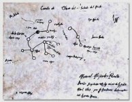
If you want to investigate the Burbridge map , first reverse it . The half arrow which points the north has this meaning .

Mapa.jpg
 

cw0909

Silver Member
Dec 24, 2006
4,364
3,222
Primary Interest:
Other
thanks Hal, but since they have maps, that had belonged to Peg-Leg
and an intention to look for treasure, using the maps, i dont think
i would get any info, about
Peg-Legs whereabouts from them, i would
hold that type of info close too
 

OP
OP
Hal Croves

Hal Croves

Silver Member
Sep 25, 2010
2,659
2,695
Hal

If you want to investigate the Burbridge map , first reverse it . The half arrow which points the north has this meaning .

View attachment 1198544

You are assuming that that image is of the original.

It may be and you may be correct about reversing the image but, we would need to see the authenticated original.
Cuenta de Oro del Rio Solado del Norte is the real deal... if you believe those involved.
I certainly do.
 

OP
OP
Hal Croves

Hal Croves

Silver Member
Sep 25, 2010
2,659
2,695
thanks Hal, but since they have maps, that had belonged to Peg-Leg
and an intention to look for treasure, using the maps, i dont think
i would get any info, about
Peg-Legs whereabouts from them, i would
hold that type of info close too

That is disappointing to read. I guess the quote "history belongs to everyone" is conditional.

Look at Peg-Leg's father and brothers.
I am still trying to build a timeline but remember, a group of Texans tried taking New Mexico in 1841 and got whooped. They tried it again twenty years later and again failed.
Two decent opportunities to plunder a Mexican treasure map.

Would it make sense to find an old Peralta family map in Santa Fe or Peralta (NM), or Mesilla?
 

cw0909

Silver Member
Dec 24, 2006
4,364
3,222
Primary Interest:
Other
i may ask anyway, all they can say is no info, this bit you put up might be
enough, for me to see whats what thanks

That is disappointing to read. I guess the quote "history belongs to everyone" is conditional.

Look at Peg-Leg's father and brothers.
I am still trying to build a timeline but remember, a group of Texans tried taking New Mexico in 1841 and got whooped. They tried it again twenty years later and again failed.
Two decent opportunities to plunder a Mexican treasure map.

Would it make sense to find an old Peralta family map in Santa Fe or Peralta (NM), or Mesilla?

I may not be the best person to ask this question. There are others, closer to the Tumllinsons, who should now be able to offer an accurate timeline of Peg-Legs life.
I am still hoping that I am wrong about Peg-Leg's service in the War of 1861-65. If it is correct, it is insane.

Leave open the possibility of Peg-Legs father or uncle first acquiring the "original", "original" map(s).
They may be your "Phoenix Area" connection.
And don't forget Bell Tumlinson, Peg-Legs 2nd cousin, who arrived in Phoenix in 1917 and filed claims in the 1930's.
 

lgadbois

Sr. Member
Mar 20, 2003
299
253
The narration of the location of a church treasure, the Anatomy of a Treasure Hunt, by Robert L. Kesselring and Lynda R. Kesselring is interesting. They were unable to get excavation permits for the old mine.
 

OP
OP
Hal Croves

Hal Croves

Silver Member
Sep 25, 2010
2,659
2,695
The narration of the location of a church treasure, the Anatomy of a Treasure Hunt, by Robert L. Kesselring and Lynda R. Kesselring is interesting. They were unable to get excavation permits for the old mine.
Robert & Lynda Kesseiring have done some amazing work on the stone maps IMO. Their five part article is not perfect but still well worth reading.
 

Not Peralta

Bronze Member
Mar 23, 2013
2,167
3,061
Primary Interest:
All Treasure Hunting
Hal and Markmar,:coffee2: Interesting you now have returned back to talking about Aylors Arch. History may not record this,But,by a few old timers,It was also known as Dark Circle as I mentioned before.
The Dark Circle Clue was to be used as a locater at night,therefore,the name Dark Circle, It was to be used to view Black Mesa and line up a Star with the sky line to show a location,this is a very easy and smart way to always be able to locate something, you only have to understand how to use these clues.good luck.NP:cat:
 

markmar

Silver Member
Oct 17, 2012
4,119
6,260
Primary Interest:
All Treasure Hunting
You are assuming that that image is of the original.

It may be and you may be correct about reversing the image but, we would need to see the authenticated original.
Cuenta de Oro del Rio Solado del Norte is the real deal... if you believe those involved.
I certainly do.

Hal

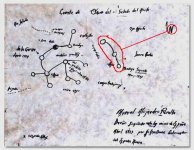
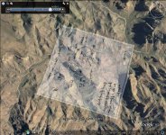
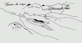
I believe the Burbridge map is about gold placers , north from Black Top to Needle Canyon . and not mines . Most of the circles show mountains top and hills . The black circle could be a cache/mine .
This map shows the same placer region with the " Teseoro de mapa " .

The Burbridge map overlayed and the " Teseoro de mapa " .

Burbridge map.jpg Ojo.gif
 

Last edited:
OP
OP
Hal Croves

Hal Croves

Silver Member
Sep 25, 2010
2,659
2,695
Hal and Markmar,:coffee2: Interesting you now have returned back to talking about Aylors Arch. History may not record this,But,by a few old timers,It was also known as Dark Circle as I mentioned before.
The Dark Circle Clue was to be used as a locater at night,therefore,the name Dark Circle, It was to be used to view Black Mesa and line up a Star with the sky line to show a location,this is a very easy and smart way to always be able to locate something, you only have to understand how to use these clues.good luck.NP:cat:

Yes, I am not surprised that conversations about lost treasure eventually return to their starting place.
Very interesting this Dark Circle idea.

Spanish/Mexicans associated the arch with the eye of an eagle.
The next group (Americans) used a horse.
It would be interesting to know when the change occurred.
 

OP
OP
Hal Croves

Hal Croves

Silver Member
Sep 25, 2010
2,659
2,695
Hal

I believe the Burbridge map is about gold placers NE from Black Top to Needle Canyon . and not mines . Most of the circles show mountains top and hills . The black circle could be a cache/mine .
This map shows the same placer region with the " Teseoro de mapa " .

The Burbridge map overlayed and the " Teseoro de mapa " .

View attachment 1198892 View attachment 1198893

markmar,
I want to spend a little time looking at your overlay before I comment.
Very curious.
 

markmar

Silver Member
Oct 17, 2012
4,119
6,260
Primary Interest:
All Treasure Hunting
Hal

Also , in the Burbridge map , the three connected dots which are separated , could be the tail of the Polaris constelation ( small Ursa ) . So , looking through the Ojo to Polaris , you will see the region from the map and the direction to the black dot .

Polaris.JPG
 

Last edited:

roadrunner

Bronze Member
Jan 28, 2012
1,230
520
Pinal Mountains,Arizona
Detector(s) used
Garrett Groundhog-2012-1st MD.
White's Goldmaster V/Sat-2nd-MD-2013
Tesoro Lobo-2015-3rd
Primary Interest:
Prospecting
Hal

Also , in the Burbridge map , the three connected dots which are separated , could be the tail of the Polaris constelation ( small Ursa ) . So , looking through the Ojo to Polaris , you will see the region from the map and the direction to the black dot .

View attachment 1199259 [/
QUOTE]

But what day and month and what soltace would we look through the eye.
With out any of that info the spot will move.
 

OP
OP
Hal Croves

Hal Croves

Silver Member
Sep 25, 2010
2,659
2,695
Ok.Did not know that. Thanks.

I wouldn't get too tied to the idea of a time specific map. There is nothing obvious on the map that instructs us to wait for moonlight or stars. I think that Ojo is simply a landmark or a reference point. It could also be an observation point.

markmars placement of the map is worth considering. I am not sure if its correct but the idea is interesting.
It comes down to symbols again and what they actually mean compared to what we think they mean.

In this case what do the circles and the lines that connect them represent? Once you think that you can read it, you will want to compare it to the master-map.
Because if it can be proven that they are connected in some critical way, then we have 100% proof that the Peraltas or, others before them, were at least in the Superstitions, making maps and strange markings about whatever it was they were doing or finding there.
 

markmar

Silver Member
Oct 17, 2012
4,119
6,260
Primary Interest:
All Treasure Hunting
Hal

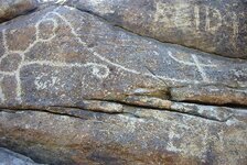
I believe were the same people who made the petroglyphs on the south end of Black Top .

434302.jpg
 

Status
Not open for further replies.

Top Member Reactions

Users who are viewing this thread

Top