Continuum

Matthew Roberts

Bronze Member
Apr 27, 2013
1,131
4,955
Paradise Valley, Arizona
Primary Interest:
All Treasure Hunting
Did Fish himself reveal where, when, how and from whom this map came into his possession? Not someone else's story, but Fish's own words.

sdcfia,

Frank Fish never revealed exactly who he received the map from, only that it came from a member of the Peralta family whose ancestor survived a massacre in the Superstition Mountains.

Al Reser later bought the original map from Wm. Schaefer (husband of Erie Schaefer) and donated it to the Superstition Mountain Museum.

Al was a good friend of mine and showed me the map once while visiting at my ranch at New River. Al told a different story of the maps origin.

According to Al, it was Pete (Pedro F. Peralta) who sold the map to Frank Fish who had a museum and treasure business in Amador, California. Pete Peralta lived in Riverside, California and was a descendant of the Superstition Mountains Peralta's. Pete Peralta became a partner with Frank Fish, John Burbridge, the Schafer's and several others in searching the Superstitions using the "Fish - Peralta" map.

The Peralta that Frank Fish acquired the map from was actually his partner, Pete Peralta.

This is what Al told me and it makes sense. Al said he got the account from Bill Schaefer, the man who sold Al the map.
 

coazon de oro

Bronze Member
May 7, 2010
1,623
3,858
texas
Primary Interest:
All Treasure Hunting
sdcfia,

Frank Fish never revealed exactly who he received the map from, only that it came from a member of the Peralta family whose ancestor survived a massacre in the Superstition Mountains.

Al Reser later bought the original map from Wm. Schaefer (husband of Erie Schaefer) and donated it to the Superstition Mountain Museum.

Al was a good friend of mine and showed me the map once while visiting at my ranch at New River. Al told a different story of the maps origin.

According to Al, it was Pete (Pedro F. Peralta) who sold the map to Frank Fish who had a museum and treasure business in Amador, California. Pete Peralta lived in Riverside, California and was a descendant of the Superstition Mountains Peralta's. Pete Peralta became a partner with Frank Fish, John Burbridge, the Schafer's and several others in searching the Superstitions using the "Fish - Peralta" map.

The Peralta that Frank Fish acquired the map from was actually his partner, Pete Peralta.

This is what Al told me and it makes sense. Al said he got the account from Bill Schaefer, the man who sold Al the map.

Howdy Matthew,

Could Pete, and Frank Peralta be the same person? Pedro Francisco Peralta?

Never mind, I went back and found that Greg had put the full name.
 

Last edited:

Matthew Roberts

Bronze Member
Apr 27, 2013
1,131
4,955
Paradise Valley, Arizona
Primary Interest:
All Treasure Hunting
Howdy Matthew,

Could Pete, and Frank Peralta be the same person? Pedro Francisco Peralta?

Yes, Peraltas name was Pedro Francisco Peralta and he went by either Pete or Frank, mostly Pete.

Peralta was a good guy but he had some legal troubles and preferred not to use his given names Pedro and Francisco. He shunned publicity which may have been why his name was not given by Frank Fish and Erie Schaefer.
 

Hal Croves

Silver Member
Sep 25, 2010
2,659
2,695
Greg Davis researched the history of the Fish map and wrote a good article on it which was published in the Superstition Mountains Volume 12, 1994, the original article with the photo of the map appears in “Men In Adventure,” Vol. 1, No. 2, July 1959, page 30-33. The story was titled “Meet Mr. Buried Treasure” by Lieutenant Harry E. Rieseberg. The photo of the map is on page 31. Somehiker had posted this info a while ago but it was originally posted by Greg Davis on that "other channel" forum and worth hunting up if anyone is interested in the history of this treasure map.

I would respectfully disagree on your logic point there, it is human nature to wish to share good news and if anyone had any success with the Fish map we would be hearing about it or I should say we would have heard about it. The finder(s) might well have had any treasure/gold mine seized by the Feds but they would have announced it to the world. I stand by the statement that the Fish treasure map has not resulted in anyone having success finding a gold mine or treasure. (Anyone is welcome to prove my statement wrong there too.)

Steve - you are so right.
It is obvious that something is wrong with every one of these treasure maps. It has to be either a deliberate deception by the map makers themselves, or some kind of mistake that is causing the same end results - failures to find anything of value other than fresh air, exercise and pretty country.

:coffee2: :coffee: :coffee2: :coffee2:

oroblanco,
I would argue that the map has been repeatedly misinterpreted due to its poor legibility. Improve the resolution, and lower the chance for mistakes. With that said, I am now able to define a potential search area for two of the mines and to offer an intelligent explanation for the location, backed by compelling circumstantial evidence. It would only be an educated guess, but I would be willing to make a gentleman's bet on it being correct.
 

Oroblanco

Gold Member
Jan 21, 2005
7,838
9,830
DAKOTA TERRITORY
Detector(s) used
Tesoro Lobo Supertraq, (95%) Garrett Scorpion (5%)
If I were to follow a treasure map, any treasure map, and locate a mine or treasure using that map, you can believe 100% that neither you nor anyone else would ever know about it. Treasure Net however seems to be full of people who can't wait to talk about all the mines and treasures they found or know exactly where they are at.

Not to doubt your word there, but even people whom were supposedly sworn to secrecy, made sure to "leak" out their story after a while. I am referring to the famous 'Pit' mine saga. It is human nature, laws, regulations and seizures by the Feds be dammed, human beings want to tell good news. It would almost be like keeping it a secret if you had a new baby born to you. Ain't gonna happen 99.9998% of the time!

On the Frank Fish map, we have to wonder if it was the real deal, absolutely genuine, then why did it not work out for Frank Fish? Shouldn't we be reading about his success? Considering that he did not have any success with this map, and proceeded to allow it to be published, Fish himself must have had serious doubts about how good that map was. For while it is human nature to wish to share good news, likewise it is in the nature of treasure hunters to retain their most precious information concerning lost mines and treasures, keeping such information closely guarded. I know that I would not be publishing a genuine treasure map, unless I had already found the mine(s) and or treasure(s) the map supposedly leads to.

The Peralta that had the store ended up committing suicide, as a side note here. The details have been posted some time ago.


:coffee2: :coffee2: :coffee: :coffee2:
 

Matthew Roberts

Bronze Member
Apr 27, 2013
1,131
4,955
Paradise Valley, Arizona
Primary Interest:
All Treasure Hunting
Oroblanco,

It was not Pete Peralta who committed suicide it was Frank Fish and most believe it was murder not suicide. Fish had just made a find of valuable treasure items in Last Chance canyon and was talking with someone late into the night at his museum store in Amador. He retired to his trailer behind the store about 2:00 am and was found dead next day with a gunshot wound to his neck. His store and museum had been robbed and the gold chain Fish always wore had been torn from his neck. Suicide was the official cause but many including Erie Schaefer firmly believe Fish was murdered.
 

Hal Croves

Silver Member
Sep 25, 2010
2,659
2,695
Apache hid only the LDM inclined shaft which was in their Holy land and the other mines on that land have been hidden by the Mexicans prior 1853 and remain covered by then.
When Waltz gave the clues to Holmes and told about a circle of rocks on a sadle before Holmes would go to the top of the ridge above Waltz camp ( house ruin ), I have understood immediately how that circle is one of the mines depicted in the Minas del Oro map, up on the sadle and between the Casa Caverna and Tunel . This portion of that map is a reproduction of the Perfil mapa without the face profil, but adds the mines on the sadle and one mine below.

IMO, in the " Salazar Survey " trip the Peraltas worked and made a survey for only one mine. They used imaginary lines, one from Casa Caverna to the first summit from their camp at the Salt River and another from WN in a specific direction, which intersected above that specific mine. For that mine were made some maps like the Gonzalez-Clark map ( with the line from the WN to the Four Peaks ), the Ortiz map, the Cuenta de Oro map ( the black dot ), Minas del Oro map and is depicted also in the Fish map ( the middle from the three in line ).

Edit: Changed the Oro de Indios map with MInas del Oro map.

markmar,

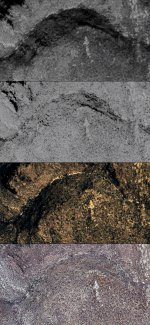
This symbol, an arrow with tail has been in the SWA since at least 1992. The main arrow is two hundred feet long and points to North. Any thoughts on what it means and who might have created it?

Arrow Symbol.jpg
 

Oroblanco

Gold Member
Jan 21, 2005
7,838
9,830
DAKOTA TERRITORY
Detector(s) used
Tesoro Lobo Supertraq, (95%) Garrett Scorpion (5%)
Oroblanco,

It was not Pete Peralta who committed suicide it was Frank Fish and most believe it was murder not suicide. Fish had just made a find of valuable treasure items in Last Chance canyon and was talking with someone late into the night at his museum store in Amador. He retired to his trailer behind the store about 2:00 am and was found dead next day with a gunshot wound to his neck. His store and museum had been robbed and the gold chain Fish always wore had been torn from his neck. Suicide was the official cause but many including Erie Schaefer firmly believe Fish was murdered.

I believe you are mistaken about the Peralta, it was this one:

sn960607961897-11-0613image681x648from1705x2868to3673x4743.jpg

Miguel Peralta had been one of the owners of the Valenciana mine in the Black Canyon country and sold it to open the store(s) in Phoenix etc.

:coffee2: :coffee: :coffee2:
 

Hal Croves

Silver Member
Sep 25, 2010
2,659
2,695
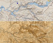
I never realized how much of Mormon Flats was lost until seeing these two maps side by side.

Salt River Compare.jpg
 

markmar

Silver Member
Oct 17, 2012
4,117
6,259
Primary Interest:
All Treasure Hunting
markmar,

This symbol, an arrow with tail has been in the SWA since at least 1992. The main arrow is two hundred feet long and points to North. Any thoughts on what it means and who might have created it?

View attachment 1748995

I don't believe is manmade. Actually it points about 8* N-NW. I don't see any connection with something worth to investigate.
 

Al D

Bronze Member
Jul 23, 2011
2,066
3,525
Gold canyon AZ
Detector(s) used
DJI Air 2S
Primary Interest:
Cache Hunting
An anyone provide the coordinates for this arrow? Thanks in advance
 

Hal Croves

Silver Member
Sep 25, 2010
2,659
2,695
I don't believe is manmade. Actually it points about 8* N-NW. I don't see any connection with something worth to investigate.

I thought that you were going to write that it was made in the 1900's.
But its a natural formation?


Its fairly symmetrical and almost perfectly aligned to North. Also, the location on a hillside that can be seen traveling North suggests that it was used as a directional sign. If it was made by humans and not modern, it may be described on the PF Map. The translations on the map copies aren't exact.
 

markmar

Silver Member
Oct 17, 2012
4,117
6,259
Primary Interest:
All Treasure Hunting
I thought that you were going to write that it was made in the 1900's.
But its a natural formation?


Its fairly symmetrical and almost perfectly aligned to North. Also, the location on a hillside that can be seen traveling North suggests that it was used as a directional sign. If it was made by humans and not modern, it may be described on the PF Map. The translations on the map copies aren't exact.

From what i know, this arrow is not depicted in any treasure map and never was mentioned by early treasure hunters in their accounts as a clue to something worth or as a directional marking.
 

Hal Croves

Silver Member
Sep 25, 2010
2,659
2,695
From what i know, this arrow is not depicted in any treasure map and never was mentioned by early treasure hunters in their accounts as a clue to something worth or as a directional marking.

You are correct. I have two books on treasure symbols and the arrow with a curved tail isn't shown. But it may have been their own adaptation of the arrow symbol which was used "on to next symbol" or "treasure here". That curved tail points to 260 degrees. Could it be pointing at the mine furthest to the right on the map? Or change direction here?

I doubt that its natural but as to the age, I honestly don't know. Could be modern (1900's).
 

Hal Croves

Silver Member
Sep 25, 2010
2,659
2,695
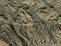
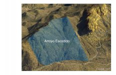
This is based on my interpretation of the original Peralta Fish Map. The Arroyo Escondido, the hidden gulch exactly where it is drawn on the PFM.

Arroyo Escindido.jpg
 

Last edited:

Hal Croves

Silver Member
Sep 25, 2010
2,659
2,695
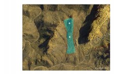
And a search area for the two "mina" which should be found on the south side of the arroyo, closer to the top.
Again, this is just a guess and the white crosses don't represent exact locations.

The area is interesting.

"Remains of an old arrastra were visible until the 1950s."
"Spanish/Mexican mining or treasure symbols found carved into rock."
"Ruth's remains"

Treasure Tales of the Superstitions

Arroyo Escondido Mina Search Area.jpg
 

markmar

Silver Member
Oct 17, 2012
4,117
6,259
Primary Interest:
All Treasure Hunting
This is based on my interpretation of the original Peralta Fish Map. The Arroyo Escondido, the hidden gulch exactly where it is drawn on the PFM.

View attachment 1749140

Hal

IMO, the Arroyo Escondido is the next to the right of yours at the beginning of Bull Pass Trail.

The solution of the PFM is in front of your eyes. If you look at the map, you can see how some words and the XS of the upper three mines are written in a different and same angle than the title ( which is an example to follow ) and the other words. Also the river follows that different way. To put the mines in their correct place follow the rule ; 50 cargas = 5Xs and one more X for the lower mine.
 

Last edited:

Top Member Reactions

Users who are viewing this thread

Top