After 25 years, Im finally seeking outside help with this one.

OP
OP
Stroover

Stroover

Full Member
Mar 28, 2006
119
1
Canadian East Coast

gollum

Gold Member
Jan 2, 2006
6,729
7,596
Arizona Vagrant
Detector(s) used
Minelab SD2200D (Modded)/ Whites GMT 24k / Fisher FX-3 / Fisher Gold Bug II / Fisher Gemini / Schiebel MIMID / Falcon MD-20
Primary Interest:
All Treasure Hunting
Re: After 25 years, I'm finally seeking outside help with this one.

Stroover said:
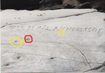
:-\ Geez! You're good, Gollum! I'll have to pay close attention to whatever's below the "5" to confirm it's actually nothing natrural but man-made. Assuming it IS a pointer, what do you make of it? Kind of looks like veer left towards the sunset/sunrise.

I'm not too familiar with French or French-Canadian Symboligy (Is that a word?). If it were Spanish, I'd say the Sun Symbol stood for sunrise. The Spanish would use a circle (or half circle) with light rays for sunrise and a plain circle (or half circle) to denote sunset. If you can figure out the alignment holes, look for something on that path that looks like a flower or sun. It's kind of involved, but here goes:

1. If the faded carving means go East and turn North, you will have to know how far East to travel before turning North. This may be the relevance of the 1505.

2. The faded carving may mean to decode the alignment marks, and look along the aligned path. Somewhere along or beyond the alignment, there will either be a carving or some type of sign that is like either a Sun or Flower. This could be a rock carving, a carving on a tree, a stone monument, or something natural. Once you get to the monument, then turn left. The distance to travel may be at (or on) the monument. The 1505 may also have something to do with that as well. For instance..... Guess at the alignment, find the flower/sun marker, and travel 1505 paces/meters/whatever. That means start the pacing at the main rock, pace off the distance to the marker, and then turn left and pace off the remaining distance. I say to do it this way, because the main rock tells you to go a distance and turn left, and go a further distance.

Good Luck-Mike
 

gollum

Gold Member
Jan 2, 2006
6,729
7,596
Arizona Vagrant
Detector(s) used
Minelab SD2200D (Modded)/ Whites GMT 24k / Fisher FX-3 / Fisher Gold Bug II / Fisher Gemini / Schiebel MIMID / Falcon MD-20
Primary Interest:
All Treasure Hunting
Re: After 25 years, I'm finally seeking outside help with this one.

A couple of more things for you:

1. Circle w/arrow. There appears to be an arrow pointing at the hole in the red circle. I can't be sure if the arrow is natural or not. You'll have to look at that one when you go back.

2. Plain Yellow Circle. There looks like something carved but badly faded under the "U" I can't tell because there is not much contrast, and the pic's resolution is poor. If you have a higher resolution picture you want to email me, I'll be glad to look it over closer for you.

Mike
 

Attachments

  • canbig1.jpg
    canbig1.jpg
    89.1 KB · Views: 3,652

Monk

Sr. Member
Sep 10, 2004
270
19
Where ever my coffee cup lands
Detector(s) used
Fisher 1280X
Re: After 25 years, I'm finally seeking outside help with this one.

Stroover, I have been reading all theorys posted to this thread, My guess is you wont live long enough to check out anything as far away as 1505 feet, ect. To me it makes more sense to be much closer.( The next mark or treasure if not already recovered?)
As far as the holes in the stone! To me there all natural. and if so you will see them all over the stone everywhere.
The code would be plain to those meant to read it. The key to me would still be the 1505. = 11 degrees North, 65 feet,etc distance. And a new thought? If meant to be taken in reverse? = 5 degrees North, and 150 feet, ect distance. Or 5 degrees North for 60 feet, ect.
Means you say the land is so hard to walk there. likely if something was ever buried there they didn't walk far eather. Plus what would make the area good for a burial spot is ( Who would want to be walking at the spot?)
Its my guess that if there is something there to find it will be closer to the stone then far away.
I'd hate to see you spending your life there beating bushes as you could if it's far off. I feel it's not. So you have fun ya hear!
 

gollum

Gold Member
Jan 2, 2006
6,729
7,596
Arizona Vagrant
Detector(s) used
Minelab SD2200D (Modded)/ Whites GMT 24k / Fisher FX-3 / Fisher Gold Bug II / Fisher Gemini / Schiebel MIMID / Falcon MD-20
Primary Interest:
All Treasure Hunting
Re: After 25 years, I'm finally seeking outside help with this one.

Two quick things in reply to Monks Post:

1. From your PMs, I believe this rock spends some amount of time under water. If this is the case, everything on it would be well worn. I've seen rocks (in the desert) that have Spanish drilled holes in them. They drill many holes, and leave clues for you to figure which holes to align through. Decypher the clues and go on to the next monument.

2. Not likely to be too close again, as the close areas spend a lot of time under water. Also, not likely to be measured in feet.

Mike
 

OP
OP
Stroover

Stroover

Full Member
Mar 28, 2006
119
1
Canadian East Coast
Re: After 25 years, I'm finally seeking outside help with this one.

Monk said:
Means you say the land is so hard to walk there. likely if something was ever buried there they didn't walk far eather. Plus what would make the area good for a burial spot is ( How would want to be walking at the spot?)

If to arrive at the spot by boat, then it's not far to walk at all (about 100 feet from shore at low tide), like the people who wrote on the rock likely arrived there with. If you're like me and have no boat, then you have to walk there, and like I said, it's a long walk.
 

OP
OP
Stroover

Stroover

Full Member
Mar 28, 2006
119
1
Canadian East Coast
Re: After 25 years, I'm finally seeking outside help with this one.

We went to the site yesterday. Still no treasure (assuming there IS any), but we DID find something interesting: We only had a 4 hour window of opportunity (that's including the 1 1/2 hour to the site from the wash-out spot where the presque-isle becomes and island, plus 1 1/2 hour back, so really only 1 hour of hunting) before the tide came back up and stranded us there, so we had to work quickly and strategically. First, from the rock, we meandered about searching for other markers nearby; nothing. Then, we decided to head southwards, as north simply goes out to sea. It lead us to a cape, so we climbed it (wasn't easy, but I fealt we had to go there). Upon reaching the top, there was a heavily wooded plateau. We kept heading south, and not 50 metres in there was a clearing with what looked like a sinkhole or pit. An anomale to say the least. I went down the pit with my md and immediately got signals. Our first reaction was "Maaaan! another Oak Island!". Nails, spikes (veeeery long spikes, some were almost 2 feet long), and bricks. Obviously a structure of some kind had been there. We quickly ruled out sink hole, which left a possible house. We go out of the hole and start md'ing around it. A beep indicating a large metal object. We dig, and it was what looked like the door to a wood stove, but only half of it. And among it was fragmented pieces of porcelain or china. I started to hear seagulls and so checked out the tide situation, and sure enough it was starting to come back up. With an hour and a half trek back to the wash-out spot ahead of us, we decided to pack it up and head back until another day. My partner continued back west on the plateau while I climbed back down and followed the shore south (which coincidently is the same direction back to the car). We met back at the wash-out spot, I found nothing of interest, but my partner found two more similar sites as the first one. We're talking about a 2 Km presque-isle/island (depending on the time of day) with 3 possible homesteads that nobody knows about, with the third one pretty much 1.5 Km north of the stone. On our next trip we will focus more on this 3rd site, and we intend on camping on the island for a couple of days as to not be at the tide's mercy. I should have taken more pictures then I did, but we were racing against the clock and I just wasn't with it. The nord stone hadn't changed (and unfortunately Gollum's keen eye had not picked up half a sun nor an arrow) so no new pics there, but I'll post one of the pit, the porcelain, spike, and the wash-out spot.
 

OP
OP
Stroover

Stroover

Full Member
Mar 28, 2006
119
1
Canadian East Coast
Re: After 25 years, I'm finally seeking outside help with this one.

Hmm. I don't know how to shrink the size of the pictures. Each one is almost 500 Kb, and so I can't post them here. Can anyone tell me how to do this? For some reason I didn't encounter this problem with the original picture at the beginning of this thread. ???
 

gollum

Gold Member
Jan 2, 2006
6,729
7,596
Arizona Vagrant
Detector(s) used
Minelab SD2200D (Modded)/ Whites GMT 24k / Fisher FX-3 / Fisher Gold Bug II / Fisher Gemini / Schiebel MIMID / Falcon MD-20
Primary Interest:
All Treasure Hunting
Re: After 25 years, I'm finally seeking outside help with this one.

Stroover said:
Hmm. I don't know how to shrink the size of the pictures. Each one is almost 500 Kb, and so I can't post them here. Can anyone tell me how to do this? For some reason I didn't encounter this problem with the original picture at the beginning of this thread. ???

You will need photo editing software such as Adobe Photoshop or something like it to resize the picture. If you don't have anything like it, you can email me the picture at [email protected]. I'll resize and post the picture for you.

Mike
 

gollum

Gold Member
Jan 2, 2006
6,729
7,596
Arizona Vagrant
Detector(s) used
Minelab SD2200D (Modded)/ Whites GMT 24k / Fisher FX-3 / Fisher Gold Bug II / Fisher Gemini / Schiebel MIMID / Falcon MD-20
Primary Interest:
All Treasure Hunting
Re: After 25 years, I'm finally seeking outside help with this one.

Hey Stroover,

Here you go. If you want a pic that's not here, just let me know and I'll get it up.

Mike
 

Attachments

  • Coast1.jpg
    Coast1.jpg
    39.7 KB · Views: 3,532
  • Coast2.jpg
    Coast2.jpg
    41.8 KB · Views: 3,494
  • Spike1.jpg
    Spike1.jpg
    97.4 KB · Views: 3,498

gollum

Gold Member
Jan 2, 2006
6,729
7,596
Arizona Vagrant
Detector(s) used
Minelab SD2200D (Modded)/ Whites GMT 24k / Fisher FX-3 / Fisher Gold Bug II / Fisher Gemini / Schiebel MIMID / Falcon MD-20
Primary Interest:
All Treasure Hunting
Re: After 25 years, I'm finally seeking outside help with this one.

and more......
 

Attachments

  • Depression1.jpg
    Depression1.jpg
    70.9 KB · Views: 3,459
  • Depression2.jpg
    Depression2.jpg
    66.2 KB · Views: 3,410

gollum

Gold Member
Jan 2, 2006
6,729
7,596
Arizona Vagrant
Detector(s) used
Minelab SD2200D (Modded)/ Whites GMT 24k / Fisher FX-3 / Fisher Gold Bug II / Fisher Gemini / Schiebel MIMID / Falcon MD-20
Primary Interest:
All Treasure Hunting
Re: After 25 years, I'm finally seeking outside help with this one.

fleamistress said:
Chagy.

Not to burst your bubble but the 4th down--the one that's wiggly looking--is a fertility symbol. ;D

Cyn

Yes, the way I understand it is that the squiggles represent the individual's sperm count in millions.

Actually, each squiggle would represent a measure of distance, with the head aiming in the direction of travel.
 

OP
OP
Stroover

Stroover

Full Member
Mar 28, 2006
119
1
Canadian East Coast
Re: After 25 years, I'm finally seeking outside help with this one.

Guys, there aren't any of those symbols on the rock, so it's irrelevent. We're going back at some point within the next month to camp out there. We're going as prospectors as to not blow our cover (which is not entirely untrue since we have our prospector's licenses and there are places along that same coast with gold claims). I'll keep you posted on our progress.
 

Monk

Sr. Member
Sep 10, 2004
270
19
Where ever my coffee cup lands
Detector(s) used
Fisher 1280X
Re: After 25 years, I'm finally seeking outside help with this one.

Stoover, It's likely the marked rock was high and dry at the time the mark was cut into it. In the last 200 years the way the ice caps have melted the sea level could have risen a couple of feet.
Plus did you ever run through the course I gave you pertaining to the 1505? And consider that what distance that is give on stone may be only 1/2 the distance that you are to go? And if you never had that inside information you couldn't find your mark. Have fun, and good luck.
 

OP
OP
Stroover

Stroover

Full Member
Mar 28, 2006
119
1
Canadian East Coast
Re: After 25 years, I'm finally seeking outside help with this one.

Monk said:
Stoover, It's likely the marked rock was high and dry at the time the mark was cut into it. In the last 200 years the way the ice caps have melted the sea level could have risen a couple of feet.
Plus did you ever run through the course I gave you pertaining to the 1505? And consider that what distance that is give on stone may be only 1/2 the distance that you are to go? And if you never had that inside information you couldn't find your mark. Have fun, and good luck.

Like I mentioned a few posts up, we found nothing in the immediate vacinity of the stone plus the stone is always high and dry (never submerged). We didn't have enough time to poke and prod as the tide was coming in fast, but this is where we plan to focus our attention on our next expidition to the site in the next month or so. Thanks for your input, Monk!
 

nhbenz

Gold Member
Dec 30, 2004
6,821
6,848
Brentwood, NH
Detector(s) used
White's Classic SL
White's Surf P.I.
Re: After 25 years, I'm finally seeking outside help with this one.

Dang Dowser, that sounds convincing. I know nothing on the subject, so I wont comment on its validity. I hope you're exactly right. Regardless, welcome to TreasureNet! -Ben
 

dowser 501

Full Member
Apr 26, 2006
140
2
Re: After 25 years, I'm finally seeking outside help with this one.

Actually I have become an amateur student of petrographs ( rock drawings) and I have hundreds of photos of jesuit markers, and know the meanings and measurements of most. I will be putting out a book on it one day. The most important two hints on the Jesuits is that firstly they were never allowed to use the same symbol twice, and yet there are enough common traits between their secret codes that another jesuit would know tnstantly where to dig two centuries later.And expect nine booby traps and items of misinformation for one credible clue. The one in the photo should show companion rocks nuzzling it. Not enough info.
 

OP
OP
Stroover

Stroover

Full Member
Mar 28, 2006
119
1
Canadian East Coast
Re: After 25 years, I'm finally seeking outside help with this one.

So Dowser, are you saying all this time the worded message was nothing, and I should have been focussing on the holes and such? Like two different entities are involved at different times? Hmmm, can't wait to go back, now. You know, now that I think of it, the three holes by themselves on the upper right kind of match with the layout of the three indentations we found a little ways away that turned out to be what we figure are house foundations and basements. Interesting....

Dowser (or anybody, for that matter), where could I find links to learn more about such jesuit petroglyphs and such? I think this might be the ticket...
 

Chagy

Bronze Member
Dec 20, 2005
2,226
121
Florida
Detector(s) used
JW Fishers Pulse 8X
Primary Interest:
Shipwrecks
Re: After 25 years, I'm finally seeking outside help with this one.

Stroover,

Realdetayopa Knows allot about Jesuit signs send him a PM he will be able to help you.


Best,


Chagy.......
 

dowser 501

Full Member
Apr 26, 2006
140
2
Re: After 25 years, I'm finally seeking outside help with this one.

I am in the final weeks of preparing to market my book on Spanish Jesuit treasure burials. I don't know all their markers and never will. They were all encouraged to use their own initiatives and vary from the code enough that no two deposits will ever be alike, yet were instantly recognizable by another Jesuit, no far away in time or distance.. One hint I can give you. THey never used writing as was on that rock. Even if rhey had , you next had to go to the next step which has no markers that you would recognize which has a bonus of a death trap as all Jeuit deposits do.

Back to that rock. It had seven holes above the crack, and seven is Jesuit for gold here, which means that the gold is herenot miles or even many paces away. That crack in the rock at the risk of repeating myself is the centre of a heart meaning "death trap" If you ever find a heart that is perfect with no part missing , it will mean you are in the area and thats all.That photo is missing a semblance of a curve with which with some imagination could be part of a heart. Equivalent to a masonic handshake but in two parts and sometimes 3. I think I have talked too much. It took me 22 years of almost full time study to learn what I have.
 

Top Member Reactions

Users who are viewing this thread

Latest Discussions

Top