Anyone have a Google Earth file for Florida Shipwrecks?

signal

Hero Member
Apr 30, 2011
582
428
Royal Palm Beach, Fl
Detector(s) used
Minelab CTX-3030, Minelab Exalibur II, Garrett AT Pro
Primary Interest:
Beach & Shallow Water Hunting

PhipsFolly

Hero Member
Sep 30, 2005
633
602
Treasure Coast, Florida
Detector(s) used
Minelab Sovereign Elite & Sovereign XS, Minelab Equinox 800 and Aquapulse AQ1B
Primary Interest:
All Treasure Hunting
Hi Signal... I have a set of aerial surveys of the Treasure Coast and they are extremely high resolution... The images were taken by satellite and they do NOT lose resolution as you zoom in.
They were taken when there was extremely high visibility in the ocean and one can see every detail of the bottom/reefs, etc.

However, I had to pay to get them and would not be willing to give them away. If you wished to pay for a copy of my set, I would be willing to discuss that. Please PM me if you wish to chat further about it...

Additionally, I have a set of magnetometer surveys done in St. Lucie and Martin Counties and many historical wrecks were discovered during this survey project.
 

OP
OP
signal

signal

Hero Member
Apr 30, 2011
582
428
Royal Palm Beach, Fl
Detector(s) used
Minelab CTX-3030, Minelab Exalibur II, Garrett AT Pro
Primary Interest:
Beach & Shallow Water Hunting
PhipsFolly thanks for the offer and the information. I am going to produce a KMZ file of all the wrecks and post it here on TN. I am going to start off with that. That information you paid for sounds quite impressive, I may ping you on that, thanks.

Signal
 

grossmusic

Sr. Member
Jul 19, 2013
348
445
Cape Canaveral
Detector(s) used
I detect the history: I've visited archives up & down the entire US East Coast, Bahamas, Jamaica, Kew, The Hague, etc. Have yet to go to Seville or S.American archives.
Primary Interest:
Shipwrecks
Of course everyone has their own interpretation of the facts.

I posted mine in another thread (not sure which one).

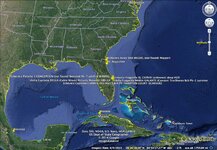
If you can tell me how to save a Google Earth file, I'm happy to share (it includes markers for the fleet's operations in New Spain as well as unchecked markers for alternate locations).

For now, here's a saved jpeg from a medium shot:
1715GoogleEarth.jpg
 

OP
OP
signal

signal

Hero Member
Apr 30, 2011
582
428
Royal Palm Beach, Fl
Detector(s) used
Minelab CTX-3030, Minelab Exalibur II, Garrett AT Pro
Primary Interest:
Beach & Shallow Water Hunting
You just click on the places on the left side of Google Earth, and right click and save, or goto File->Save Place, it should output a KML file.
 

OP
OP
signal

signal

Hero Member
Apr 30, 2011
582
428
Royal Palm Beach, Fl
Detector(s) used
Minelab CTX-3030, Minelab Exalibur II, Garrett AT Pro
Primary Interest:
Beach & Shallow Water Hunting
I formatted 700+ wrecks from the site I originally posted. Issue is they are not all in the same coordinate system! To create a KML I need all of them to be in Decimal Degrees, but its a hodgepodge. Not sure if there is a way to automatically detect coord system and coerce to DD as needed.
 

Salvor6

Silver Member
Feb 5, 2005
3,755
2,171
Port Richey, Florida
Detector(s) used
Aquapulse, J.W. Fisher Proton 3, Pulse Star II, Detector Pro Headhunter, AK-47
Primary Interest:
Shipwrecks
This is probably not exactly what you are looking for, but there is some interesting information here: Wrecks and Obstructions (AWOIS)

Hey Jolly Mon the AWOIS info is very interesting. I went to some of the wrecks listed and found them right on the numbers. I went to an anchor listed as a 8' by 12' anchor. It is a 5,000lb. freighter anchor lost in Tampa Bay back in 1978 in 20' deep water. There is also about 10,000 feet of chain. The chain links are one foot long and under each link was a stone crab! :hello2:
 

grossmusic

Sr. Member
Jul 19, 2013
348
445
Cape Canaveral
Detector(s) used
I detect the history: I've visited archives up & down the entire US East Coast, Bahamas, Jamaica, Kew, The Hague, etc. Have yet to go to Seville or S.American archives.
Primary Interest:
Shipwrecks
You just click on the places on the left side of Google Earth, and right click and save, or goto File->Save Place, it should output a KML file.

Well, not sure it'll work (I don't get the technology), but here it is. I'm a Mac user, but that shouldn't make a diff going to Windows:

View attachment My Places.kml
 

Jolly Mon

Hero Member
Sep 3, 2012
868
631
Primary Interest:
All Treasure Hunting
Hey Jolly Mon the AWOIS info is very interesting. I went to some of the wrecks listed and found them right on the numbers. I went to an anchor listed as a 8' by 12' anchor. It is a 5,000lb. freighter anchor lost in Tampa Bay back in 1978 in 20' deep water. There is also about 10,000 feet of chain. The chain links are one foot long and under each link was a stone crab! :hello2:

That's a lotta crab claws !!! :headbang:
 

OP
OP
signal

signal

Hero Member
Apr 30, 2011
582
428
Royal Palm Beach, Fl
Detector(s) used
Minelab CTX-3030, Minelab Exalibur II, Garrett AT Pro
Primary Interest:
Beach & Shallow Water Hunting
Well, not sure it'll work (I don't get the technology), but here it is. I'm a Mac user, but that shouldn't make a diff going to Windows:

View attachment 1007012

Excellent job, works great. I am thinking the 700+ I did may be hard to convert to Decimel Degrees. But if someone wants to make a stab at it, here is the attached Excel File. It can't be converted to a KML until ALL the coordinates are in Decimal Degrees.
 

Attachments

  • SHIPWRECK LIST OF FLORIDA.zip
    69.4 KB · Views: 123

Top Member Reactions

Users who are viewing this thread

Top