Are theses dredge tailings or something?

OwenT

Hero Member
Feb 11, 2015
572
858
Moses Lake WA & Provo UT
Primary Interest:
Prospecting
First thing I thought when I saw this on the Columbia River was dredge tailing, but it's actually more of a snaking pattern than the stacked arcs a dredge would make. This area on the river did produce gold. Untitled.png
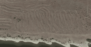


Note to anyone beginning to read this thread: It was determined that the picture shows the remnants of some sort of gold mining operation. The thread then turns a little off track and there is a debate for several pages. Finally we discuss land status and I try to find out who owns this property.
 

Last edited:
Upvote 0

Goldwasher

Gold Member
May 26, 2009
6,077
13,225
Sailor Flat, Ca.
🥇 Banner finds
1
Detector(s) used
SDC2300, Gold Bug 2 Burlap, fish oil, .35 gallons of water per minute.
Primary Interest:
All Treasure Hunting
Well thanks to both of you for doing all this free research for me :laughing7:. I thank you chlsbrns for the input especially the history links, but I'm going to have to go with Goldwasher on this one. Like I said before I don't have much faith in the accuracy of the location descriptions, not that it even changes the fact that there's gold where I found it. Just looking at this logically, where there's gold in the dirt and it seems like there's been mining activity, I'm saying this was a mine. One thing I thought about today was I don't believe this was probably a floating operation as the piles are at least 10' maybe closer to 20' above the present water line which should be about the same as it was back in the day. So here's some pictures I took. View attachment 1300658 View attachment 1300659

and those are absolutely gravels that have been through a plant. Notice you can tell that they started ith a large grizzly hence no cobbles over a certain size and no clay sticking to any cobble they have been cleaned and not from rain.

The point of cut and fill or dredge and fill ops is to use the material in the area like here the dam is built. Goes against theconcept to haul material off site.
 

Goldwasher

Gold Member
May 26, 2009
6,077
13,225
Sailor Flat, Ca.
🥇 Banner finds
1
Detector(s) used
SDC2300, Gold Bug 2 Burlap, fish oil, .35 gallons of water per minute.
Primary Interest:
All Treasure Hunting
Due to the fact that it is private land there should be no recording. The land holder therfore had no concern of the area being 'Taken" from them. So, no relevance to the mystery.
 

chlsbrns

Bronze Member
Mar 30, 2013
1,636
656
Detector(s) used
Excalibur II
Primary Interest:
Other
I said it could have been plausable. The pictures tell a different story. The piles being dumped in the pics. and the gravel plant are both farther up river than the piles near Chinamens placer area.

There are hundreds of medium to large mining ops that never got recorded and if you see the same name in an area several times it usually means that there as one location and several people put it on paper and then into the later record incorrectly because the sites are gone and hard to find once in the field. The links that get shared verify that constantl;y...most google earth layers do it consistantly antone ho uses mindat and usgs sources sees it a lot. Minecache is terrible about it.

If you compare the more recent field surveys performed by USGS to help close and make safe abandoned mines ith historical record the ne USGS surveys are missing more than fifty percent of the originally named mines. There are three hundred knon mines listed in the three mile radius around my house. locating fifty of them is very difficult for those three hundred knon there are probably double that in prospects and surface digs that never had a name.

In a river basin full of gravel and open space the engineers definetely didn't have to source gravel or fill and they didn't have to travel far to get dredged material out of the area. In the construction photos of the dam site (The pic is labled Priest Rapids keep that in mind a rapid doesnt keep its name three miles distant) you can see them lining the piles in straight lines..it is eather for a temporary earth coffer dam or part of the dam on the northern shore. looks like the area that has modular homes presently is close to those piles in the pic.

That is a placered area. There seems to be some impliment in the google earth image close to the orchard that is there...any idea hat that is? You can also see that some of the piles have been semi leveled closer to the farming area.

A historic photo predating the dam could help a lot. In the 1964 image those piles had been there for years predating the dam. The date O.t. gave as 30's-40's I suspect it as called Chinamens Bar long before the 30's and 40's

I kno Chrls thinks im just arguing none of my logical points and picture angles have been soundly disproved because they cant be. Boots on the ground should clear it up even more my points are pretty logical I hope they help.

P.s. My double u key is broke lol....and cue...its amazingly difficult to put all letters in to groups and not have those 2 letters if you could imagine:BangHead:

It amazes me how your imagination is capable of changing facts into fantasy. Maybe from banging your head against to many walls?

The pic at : CONTENTdm Collection : Item Viewer

Is a part of a historical record. The info about the pic clearly states it was a part of the dams construction.

Number 2002-850-330
Subject Dams--Priest Rapids
Title Aggregate Plant
Description Overview of Aggregate Plant.
Date Created 1958
Provenance Priest Rapids
Medium Photograph;
Hue B&W;
Height 7.5
Width 9.5
Facility Yakima Valley Regional Library;

But your imagination makes you believe it is to far from the dam to have been part of the dams construction? You know better than the historical record?

These pics must also be incorrect? CONTENTdm Collection : Search Results

The USGS is missing 50% of the mining records? Can you back up that statement or is it your imagination playing tricks again?

The piles are over a mile from chinaman bar. Chinaman bar was a dry lake bed. Strange that when you look at the long/lat in mining records and search a topo map it takes you to a dry lake bed about 1-2 miles from the piles but then again your imagination is more accurate than published records. At least according to you!

Those piles are not chinamans bar.
 

Last edited:

chlsbrns

Bronze Member
Mar 30, 2013
1,636
656
Detector(s) used
Excalibur II
Primary Interest:
Other
and those are absolutely gravels that have been through a plant. Notice you can tell that they started ith a large grizzly hence no cobbles over a certain size and no clay sticking to any cobble they have been cleaned and not from rain.

The point of cut and fill or dredge and fill ops is to use the material in the area like here the dam is built. Goes against theconcept to haul material off site.

Yes of course! I posted a link to a pic of the plant that processed.

A screening plant? I wonder why they had a screening plant?

http://www.yakimamemory.org/cdm4/item_viewer.php?CISOROOT=/relander&CISOPTR=321&CISOBOX=1&REC=15
 

Last edited:

Goldwasher

Gold Member
May 26, 2009
6,077
13,225
Sailor Flat, Ca.
🥇 Banner finds
1
Detector(s) used
SDC2300, Gold Bug 2 Burlap, fish oil, .35 gallons of water per minute.
Primary Interest:
All Treasure Hunting
that plant is at the dam. the other piles are not....so your saying they cleaned gravel for fun and then hauled it three miles just to dump it?

As mentioned the palcer location is in dispute. Your saying a river bar placer is in a dry lake?

Amazing that you run pointless irrelevant info in circles and can not seem to actually provide real info.

Google earth proves your pictures are not of the location of mystery. The area is a lot closer to the general vicinity of chinamens bar than priest rapids is the maps prove that.

Your the one that has the advanced imagination.....make sure you are pointing in the right direction at the range....huntin' pigs is more fun at minus a hundred yards...even at that distance it seems you might have accuracey issues.
 

chlsbrns

Bronze Member
Mar 30, 2013
1,636
656
Detector(s) used
Excalibur II
Primary Interest:
Other
that plant is at the dam. the other piles are not....so your saying they cleaned gravel for fun and then hauled it three miles just to dump it?

As mentioned the palcer location is in dispute. Your saying a river bar placer is in a dry lake?

Amazing that you run pointless irrelevant info in circles and can not seem to actually provide real info.

Google earth proves your pictures are not of the location of mystery. The area is a lot closer to the general vicinity of chinamens bar than priest rapids is the maps prove that.

Your the one that has the advanced imagination.....make sure you are pointing in the right direction at the range....huntin' pigs is more fun at minus a hundred yards...even at that distance it seems you might have accuracey issues.

You didnt see the pic of the cement plant? You know the cement plant where the aggregate plant hauled the rocks? Or the aerial photo that showed the whole area around the dam? The pic that doesn't show the aggregate plant because it was about three miles from the dam?

Yes chinaman placer is in a dry lake bed. Look at it on a topo map! The location is not in dispute. I actually found a pic of it! Maughan ranch owns the mineral rights to chinaman bar and numerous other locations in the area.

When do you ever provide proof of anything?

I hunt hogs with a hand gun and have shot many at less than 10 yards and some over 200 yards.
 

Last edited:

Clay Diggins

Silver Member
Nov 14, 2010
4,903
14,294
The Great Southwest
Primary Interest:
Prospecting
Chinaman Bar, which you have pictured in your original post, was worked commercially between 1939 and 1941.

The USGS MRDS you are using to attempt to locate Chinaman Bar is composed of three much older databases - the original USGS Mineral Resources Data System (MRDS 1984 - 1996), the U.S. Bureau of Mines Mineral Availability System (MAS 1962 - 1996) and the U.S. Bureau of Mines Mineral Industry Locator System (MILS 1908 - 1984). The current version of the MRDS was created by combining these old records in 1996 and 2000. Since then the database has been studied and modified to try to coordinate the many duplicates, gaps and errors. The biggest modifications were made in 2005 and all work on the databases was abandoned in 2011. No new records have been added since 1996, the MRDS is entirely composed of aggregated historical reports from hundreds of sources.

I've worked with the MRDS for years. There are many duplicates and the locational accuracy is minimal. In 2013 as part of a study of the American River we found that more than 70% of the MRDS entries were either duplicates or were mislocated by more than a mile. That's a general rule of thumb when using the MRDS about 30% reliable in any given location. The multiple entries for Chinaman Bar are typical of the USGS MRDS. Multiple locations are normal for the MRDS because multiple records for the same mine are in the database.

It's obvious to any miner that a "bar" will only be found on a waterway so it's a no-brainer to eliminate the other locations not on the river. If you study the three references in the MRDS to Chinaman Bar you will see that all three authors put the Bar on the north bank of the river in Grant County. The south bank is in Benton County so those map locations are clearly in error. There are several other specific distances and references in those reports that locate the Bar right where aerials show the existing current bar to be. A little common sense goes a long way when dealing with a locational accuracy of 30%.

The Chinaman Bar deposit is obvious if you look at the free flowing river before the Priest Rapids Dam was built in 1956 (turn on the Topo). In total Priest Rapids consisted of seven separate cataracts along a 9-mile stretch, over which the river dropped 72 feet. That's a fast flowing river by any standard. Chinaman Bar was where the river first slowed down just downstream from the rapids. Perfect conditions for a placer gold deposit. As there are no other bars nearby and it's obvious this bar has been worked it's not hard to define that area as the historical Chinaman Bar.

10 to 20 feet above the current river level is reasonable for a purpose built mining machine (doodlebug in miner speak) to process those gravels. Aerial photos show that portions of the Bar do still flood. The gravels have clearly been worked. I'm not sure what the mystery is?

With the US entry into WWII in 1942, the establishment of the Hanford site and the prision labor camp nearby shortly afterwards it's entirely possible that the placer deposit at Chinaman Bar was abandoned before it was mined out. You might have found one of those hidden treasures in plain sight. :thumbsup:

Now the big question is how you intend to arrange mining the private patented property where Chinaman Bar is located. The owner does have the mineral rights as you can see by downloading the MTP (Master Title Plat). Are you proposing a straight up purchase, lease, lease with royalty or rent to the owner? It appears the owner is aware of the deposit as your picture shows recent digging in the old workings.

Heavy Pans
 

Last edited:

chlsbrns

Bronze Member
Mar 30, 2013
1,636
656
Detector(s) used
Excalibur II
Primary Interest:
Other
Maughan ranch has the mineral rights to chinaman bar. Please take a screen shot from land matters to see if their info is correct. I would do it but I don't have patience for such a slow confusing site with so much outdated info.

BTW there are three different chinaman bar's two of them are accross the river high above the shoreline. It's just a name is doesnt mean that the mines are a part of a river bar.
 

Last edited:

Clay Diggins

Silver Member
Nov 14, 2010
4,903
14,294
The Great Southwest
Primary Interest:
Prospecting
The point of cut and fill or dredge and fill ops is to use the material in the area like here the dam is built. Goes against the concept to haul material off site.

If you look at the topo you will see the spoil bank and several borrow pits clearly marked as being just downriver of the dam on the north bank of the river. (13N 24E Section 7)

You can clearly see the aggregate plant at the dam site in this aerial view from 1959

Not surprisingly the excavation sites were left open to provide a channel and slough for the dam spillway and overflow. Those are also clearly marked on the topo.

Chinaman Bar is about a mile and a half downriver from the spillway, slough, spoil bank and pits.

Heavy Pans
 

Last edited:

chlsbrns

Bronze Member
Mar 30, 2013
1,636
656
Detector(s) used
Excalibur II
Primary Interest:
Other
If you look at the topo you will see the spoil bank and several borrow pits clearly marked as being just downriver of the dam on the north bank of the river. (13N 24E Section 7)
Not surprisingly the excavation sites were left open to provide a channel and slough for the dam spillway and overflow. Those are also clearly marked on the topo.

Chinaman Bar is about a mile and a half downriver from the spillway, slough, spoil bank and pits.

Heavy Pans

A mile and a half down river? Wrong! See pic below!

Your pic shows where the concrete was mixed not the aggregate plant. http://www.yakimamemory.org/cdm4/item_viewer.php?CISOROOT=/relander&CISOPTR=380&CISOBOX=1&REC=4

Here is a nice and easy site to navigate and get BLM info! http://www.earthpoint.us/TownshipsSearchByDescription.aspx
 

Attachments

  • Screenshot_20160417-143408.png
    Screenshot_20160417-143408.png
    285 KB · Views: 115
Last edited:

chlsbrns

Bronze Member
Mar 30, 2013
1,636
656
Detector(s) used
Excalibur II
Primary Interest:
Other
.


It's obvious to any miner that a "bar" will only be found on a waterway so it's a no-brainer to eliminate the other locations not on the river.

The south bank is in Benton County so those map locations are clearly in error

Heavy Pans

Wrong again! There are more than one chinaman bar. There is one in Grant and another in Benton County. There is a third in Benton but I don't feel like finding it.

http://westernmininghistory.com/mine_detail/10055911

http://westernmininghistory.com/mine_detail/10252544

Both of the above are far from any river "bar"
 

Last edited:

chlsbrns

Bronze Member
Mar 30, 2013
1,636
656
Detector(s) used
Excalibur II
Primary Interest:
Other
USGS and all other sites shows China Bar at:

https://goo.gl/maps/3MyHAvoJHHv
It's actually a little bit north west of the marker and about four miles from the dam.

Scroll the map south and you will see a well defined area of what looks like black sand just above the water line. Surely they had pans, rockers or whatever equipment that they used at the waters edge. They worked at the edge where the well defined area of black sands is shown.

It's a no brainer!

It's probably worth checking the black sands for gold if they are black sands.
 

Last edited:

Goldwasher

Gold Member
May 26, 2009
6,077
13,225
Sailor Flat, Ca.
🥇 Banner finds
1
Detector(s) used
SDC2300, Gold Bug 2 Burlap, fish oil, .35 gallons of water per minute.
Primary Interest:
All Treasure Hunting
If you look at the topo you will see the spoil bank and several borrow pits clearly marked as being just downriver of the dam on the north bank of the river. (13N 24E Section 7)

You can clearly see the aggregate plant at the dam site in this aerial view from 1959

Not surprisingly the excavation sites were left open to provide a channel and slough for the dam spillway and overflow. Those are also clearly marked on the topo.

Chinaman Bar is about a mile and a half downriver from the spillway, slough, spoil bank and pits.

Heavy Pans

Yep another angle of the plant shown in the pic before....right where I said it was....and not more than a mile away and not at the location of what is obviously China men's bar. Placer ed for sure with a small something or other. like I showed in my Google Earth view. Thanks for that pic Clay!
 

Goldwasher

Gold Member
May 26, 2009
6,077
13,225
Sailor Flat, Ca.
🥇 Banner finds
1
Detector(s) used
SDC2300, Gold Bug 2 Burlap, fish oil, .35 gallons of water per minute.
Primary Interest:
All Treasure Hunting
CONTENTdm Collection : Item Viewer
In the pic you can see the aggregate plant and the cement plant in the same picture. Because they are smart and not going to haul tonnage miles for no reason.
 

OP
OP
OwenT

OwenT

Hero Member
Feb 11, 2015
572
858
Moses Lake WA & Provo UT
Primary Interest:
Prospecting
Thanks Clay for pitching in. I'm going to check more on the land status, like Goldwasher said I think there's a lot of state land down there. Yesterday I realized the significance of it being worked only until '41. So hopefully there's plenty of good gold left there.
 

OP
OP
OwenT

OwenT

Hero Member
Feb 11, 2015
572
858
Moses Lake WA & Provo UT
Primary Interest:
Prospecting
Here we go. You all had me worried I was taking gold from private property for a second. When I went though I remember checking and it looked ok. Our county assessor's site shows some things that Land Matters doesn't. http://grantwa.mapsifter.com/default.aspx . It shows that the land S of SR 243 is owned my the BOR and the BLM, but the parcels don't extend to the water line. Either this is a mapping error, or like a lot of the time, the state DNR owns the land near the river.
 

Last edited:

Goldwasher

Gold Member
May 26, 2009
6,077
13,225
Sailor Flat, Ca.
🥇 Banner finds
1
Detector(s) used
SDC2300, Gold Bug 2 Burlap, fish oil, .35 gallons of water per minute.
Primary Interest:
All Treasure Hunting
The state game land looks to be close but not there. the M.T.P is the only ay to kno. It shos private on everything online. I didn't check the M.T.P did use online sources that sho the same lines. the fact that it is a patent makes the info pretty solid. looks like you need to make a trip to the county. Looks like there is a piece of machinery near those orchards yet near the tailings hard to tell hat it is do you see hat I'm talking about?
 

KevinInColorado

Gold Member
Jan 9, 2012
7,037
11,370
Summit County, Colorado
Detector(s) used
Grizzly Goldtrap Explorer & Motherlode, Gold Cube with trommel or Banker on top, Angus Mackirk Expedition, Gold-n-Sand Xtream Hand pump
Primary Interest:
Prospecting
The state game land looks to be close but not there. the M.T.P is the only ay to kno. It shos private on everything online. I didn't check the M.T.P did use online sources that sho the same lines. the fact that it is a patent makes the info pretty solid. looks like you need to make a trip to the county. Looks like there is a piece of machinery near those orchards yet near the tailings hard to tell hat it is do you see hat I'm talking about?

Good counsel. Take the trip to the county.

PS Goldwasher, it's time to buy a $10 external keyboard for that computer! Are you taking donations to fund it? ;)
 

Goldwasher

Gold Member
May 26, 2009
6,077
13,225
Sailor Flat, Ca.
🥇 Banner finds
1
Detector(s) used
SDC2300, Gold Bug 2 Burlap, fish oil, .35 gallons of water per minute.
Primary Interest:
All Treasure Hunting
Chinamens bar is located in 13n24e sec 10 and 11 but, have also been described as near the junction of 24 and 243. You piles start in section 8. The distance from your oile area to the bridge is around 4.75 miles. hen it as named after the chinamen maybe they refered to the hole 5 mile strech. I can find no info on its naming. The county library could have info. View attachment 1301171 Heres the relic I asked about could be farm machinery.

It is obvious they placered in the area of your piles. I see no evidence of larger digs farther along the bank. Old digs coould have been flooded. Or the description of old diggins and placement related the plss description could just thro it off some.

If i lived nearby that is the side of the river that I ould focus my effort on
 

Top Member Reactions

Users who are viewing this thread

Top