BakhtarRadar: A New Dimension in Non-Invasive Hydrographic Exploration and Sub-Seabed Imaging
Originally developed by Dr. Khosrow Bakhtar under the U.S. Air Force Small Business Innovative Research (SBIR) program to detect buried ordnance, BakhtarRadar is now available for civil marine applications for the first time.
BakhtarRadar’s principal marine applications are shipwreck detection and sub-seabed mapping/ volumetric imaging. It can detect metallic and non-metallic targets. In most cases, using a newly invented principle called "Forced Resonance” based on radar, BakhtarRadar can reconstruct 4-dimensional and volumetric images to better discriminate between the target and ocean floor clutter. It offers higher resolution in the MHz regime and an enhanced signal-to-noise ratio (SNR), facilitating ease of analysis and discrimination as compared to conventional systems.
Depth of penetration is up to 300 ft. of water and seabed (depending on antenna design and size of the submerged target). There are no limitations with respect to salinity, sand depth, soils or overburden.
The device is mounted on zodiacs, which are towed by the mother ship. The ship covers the search area in a zigzag pattern, then goes back over anomalies very slowly.
Seabed interrogation is triggered with a high resolution Global Positioning System (GPS), allowing transfer of the location coordinates onto any GIS system for site planning.
The technology is available through a service contract.
For more information, please contact:
David Steinman
Bakhtar Associates
PO Box 494
Bronxville, NY 10708-0494,
U. S. A.
(914) 237- 6533
email: [email protected]
Most of the marine work we've completed has been in conjunction with military and law-enforcement agencies, including, but not limited to: (1) detection and volumetric image reconstruction from plastic and metallic mines laid at the bottom of the ocean along the surf zone; (2) detection and volumetric image reconstruction of mines suspended from the ocean floor; (3) detection and volumetric image reconstruction of a murder weapon (hand gun) in the sea-floor. These reports are military-classified. But, to prove we are real, you are welcome to read our ground-based civil application demo reports, which are unclassified.
Here is a link to one that was published in the peer-reviewed Pipeline and Gas Journal (May 2002): http://goliath.ecnext.com/coms2/summary_0199-1844572_ITM&referid=2090
This article, and our other demo reports are too large to attach here. But any serious inquiries are welcome to send me a private email at [email protected] and I will be happy to email them directly back as pdf attachments.
Mr. Bakhtar,
It would be of assistance to all of us here to see an actual image capture. This will not be too large to attach once modified. We have numerous land and sea projects that would benefit from reliable technology but before discussing facts a visual would certaiunly help. Our current site is land based and we are very interested.
Thanks
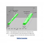
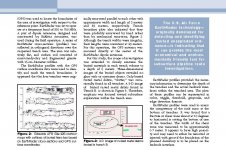
As previously posted, anyone with a serious project is welcome to email me directly for full reports demonstrating BakhtarRadar's civil ground applications, which are too large to attach here. But, wishing to respond to the request to display something in this public forum, I have excerpted from these materials an image showing 3-D underground imaging of two steel pipes and a peer-reviewed article in full (split into 3 attachments, I'm afraid. Note Figures 2 and 3 on pg. 2).
The first image is part of a field demo of subsurface mapping and 3-D image capabilities at the Naval Weapons Station, Seal Beach, Ca.
The jagged appearance of the 3-D images reconstructed is due to induced friction build up and sudden release at the interface between the skids and the asphalt surface of the street. This can easily be corrected by attaching antennae (skids) to the moving platform using rigid links. For the demonstration, a makeshift setup was deployed with nylon ties holding skids attached to the moving platform, causing excessive jerking of the sensors, which resuted in the jagged look of the reconstructed pipe images from backscatted signals. In marine apps, a stabilizer used in motion picture production can be employed to avoid jagged image appearance.
It should also be noted that these demos are several years old and the technology's capabilities have increased greatly since then.
All i see is that the device is used on land.how about marine use? have any actual scans or photos(not drawings out of your catalog)land devices like this are not new.there are plenty of makers of this device that find buried plastic and metal objects like mines etc.show us something we havent seen before.
This is very interesting technology for land. Thank you for your information.
For marine use however, nothing that is RF based can work. Water absorbs all frequencies of RF energy completely. Only a few inches of range would be possible at the operating frequencies the system uses.
Unfortunately, the only thing that travels well in water is sound.