Dutchman's Caches

OP
OP
Idahodutch

Idahodutch

Bronze Member
Sep 25, 2019
1,848
4,785
Idaho
Detector(s) used
Whites MXT
Gold Legend
Primary Interest:
Other
A Closer Look at the Ravine

I don’t know how the rest of you feel about it, but since I don’t need to worry about giving away the location of the area I like as being the site of the LDM, we might as well (or I guess who else is willing), talk about the clues that lead me to this ravine and what else is evident from what we have to work with.
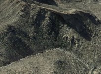
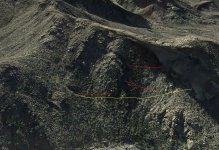
Here is a re-post of “The Ravine”, for reference.
This ravine is located in Needle Canyon, just on the North side of the saddle of Bull Pass, as it crosses over the northern part of Black Top Mesa.
1) Weavers Needle is visible above the ravine to the South. Viewed from the Western edge of the ravine’s South ridge.
2) The Four Peaks viewed as one. The tip of one of the 4 peaks is visible from above the ravine on the Eastern edge of the of the ravines South ridge.
3) The ravine faces NW.
4) The center of the ravine lies about 2500’ elevation, within a 5 mile circle with Weaver’s Needle at the center. It is actually 2.4 miles from center of ravine to center of Weaver’s Needle.
5) A continuous thicket of Scrub Oak.
6) Heading North from Weavers Needle, down a long North trending canyon, the first side canyon coming in from the east. Just a few choices here if this a legit clue, and this ravine would be one of them.
7) Pass the little red hills and you’ve gone too far. This works for entering in from first water and West Boulder Canyon, or from the North via Second Water and Boulder Canyon, or from the South via Peralta Canyon and on down Needle Canyon.
8) A rock face looking into the ravine from across the (varies, but what, canyon, ravine? ) Pretty hard not to see that one.
9) The Waltz Map points to it . . . . . Not sure what that one is worth.

I never made it back again since my last trip in ’08, and have yet to find out what close up investigation of the ravine would reveal. I have only seen it from skirting the edges.
We have all been trying to solve a mystery, and since this site is out of the bag, what could it hurt to talk about it. Maybe someone will find some answers? Maybe someone has spent some time in this ravine and can share info on what they did or did not find? Ok, I know that’s asking a lot. . . . wth, it was liberating for me
Idaho Dutch
 

Attachments

  • The Ravine.jpg
    The Ravine.jpg
    733 KB · Views: 171

markmar

Silver Member
Oct 17, 2012
4,119
6,260
Primary Interest:
All Treasure Hunting
Idahodutch

In the clue #4 , the correct clue about the 5 miles cicle that you wrote is " lies in an imaginary circle which its diameter is 5 miles and WN is in its center " written by Bicknell in his newspaper account.
I will be honest to you, and I will say how your place on that mountain side was a point from which some miners about 2 centuries ago , threw the dump and debris from a mine somewhere in the not so far vicinity. If you are lucky and skilled, is better to follow the tracks from above the ravine.
 

OP
OP
Idahodutch

Idahodutch

Bronze Member
Sep 25, 2019
1,848
4,785
Idaho
Detector(s) used
Whites MXT
Gold Legend
Primary Interest:
Other
Idahodutch

In the clue #4 , the correct clue about the 5 miles cicle that you wrote is " lies in an imaginary circle which its diameter is 5 miles and WN is in its center " written by Bicknell in his newspaper account.
I will be honest to you, and I will say how your place on that mountain side was a point from which some miners about 2 centuries ago , threw the dump and debris from a mine somewhere in the not so far vicinity. If you are lucky and skilled, is better to follow the tracks from above the ravine.

Hello markmar,
Thanks for the correction on the wording on that clue. I moved not that long ago, and haven't gotten to the boxes that my LDM files are in. (I didn't have a PC at home until maybe 10 years ago). Anyway, I wasn't trying to quote the clues, rather just bringing up the ones that fit this ravine.

There are some more that I thought of that fit such as: (markmar, so you know, I am not quoting verbatim)
10) Being able to see military trail from? mine or above mine? All I can say with reasonable certainty, is that if this really is the LDM ravine, then that clue would fit. After all, who can say what trail the military was riding on when the Dutchman saw them and where was he in relation to his mine when he saw them? anyway, moving on.
11) A place where a few pack animals could graze (the saddle above on the East).
12) On a ledge. Plenty of ledges in that ravine.
13) Water tanks below. IDK for sure, but there might be some water down there in Needle canyon most of the year. It's amazing how much GE has improved over the last decade. In viewing prior years it sure looks like there is a springs that surfaces in a couple of places in that ravine as well.
14) You can't come in from the top or the bottom, but need to come around and down into the ravine from the side, and then back up.

I did not see a "trick in the trail", but maybe that is in the ravine.
I'm curious though, who around 1819 was taking mining debris to the top of this ravine to dump it? I would say that they would have had to be the skilled ones, and strong too, with lots of energy to waste. Maybe they misunderstood the directions that were given to them, because I kind of having a hard time with that one. (edit: but please keep um coming. This is good)
 

Last edited:

markmar

Silver Member
Oct 17, 2012
4,119
6,260
Primary Interest:
All Treasure Hunting
Hello markmar,
....
I'm curious though, who around 1819 was taking mining debris to the top of this ravine to dump it? I would say that they would have had to be the skilled ones, and strong too, with lots of energy to waste. Maybe they misunderstood the directions that were given to them, because I kind of having a hard time with that one. (edit: but please keep um coming. This is good)

I believe they have not went there from below, so was not a so hard time for them.
 

OP
OP
Idahodutch

Idahodutch

Bronze Member
Sep 25, 2019
1,848
4,785
Idaho
Detector(s) used
Whites MXT
Gold Legend
Primary Interest:
Other
I believe they have not went there from below, so was not a so hard time for them.

You know, They would have still had to go up hill unless they were mining at or near the very top of the ravine, but not on the North side (inside the ravine), but the South side (Bull Pass side).
I haven't notice any specific tracks that you speak of, but it sounds like you are talking about tracks made by something to transport stuff like mining debris, up to the spot where your information says they were dumping. I would think that it would be more likely that the movement of mining material was, if anything, going in the other direction; away from the ravine (downhill). Maybe you can elaborate some more on what you are seeing?
 

markmar

Silver Member
Oct 17, 2012
4,119
6,260
Primary Interest:
All Treasure Hunting
You know, They would have still had to go up hill unless they were mining at or near the very top of the ravine, but not on the North side (inside the ravine), but the South side (Bull Pass side).
I haven't notice any specific tracks that you speak of, but it sounds like you are talking about tracks made by something to transport stuff like mining debris, up to the spot where your information says they were dumping. I would think that it would be more likely that the movement of mining material was, if anything, going in the other direction; away from the ravine (downhill). Maybe you can elaborate some more on what you are seeing?

From what I have noticed, the Spanish/Mexican miners when they wanted to keep hidden their mines in the time frame they were not there, they took the waste material from their mines and threw it on the same ridge, at a highest point ( contrary to logic but for a reason ) and on the steep side where there below would be a deep canyon/ravine able to wash down the dump.
Your place is one of those, rich in vegetation to hide the dump, steep and close to a big canyon.
 

Last edited:
OP
OP
Idahodutch

Idahodutch

Bronze Member
Sep 25, 2019
1,848
4,785
Idaho
Detector(s) used
Whites MXT
Gold Legend
Primary Interest:
Other
From what I have noticed, the Spanish/Mexican miners when they wanted to keep hidden their mines in the time frame they were not there, they took the waste material from their mines and threw it on the same ridge, at a highest point ( contrary to logic but for a reason ) and on the steep side where there below would be a deep canyon/ravine able to wash down the dump.
Your place is one of those, rich in vegetation to hide the dump, steep and close to a big canyon.

I sat and thought about this for a while. I find it interesting and I think I will have to think about it some more.
So back to the clues thing; besides there being a fit to many of the general location clues, there would also be the need, for the site in question to have landscape that would allow for other things like;
- A horses head with an ear laid back.
- Signs of additional tunneling attempts.
- A cave of some sort near the canyon floor that has natural concealment, that could have remains of a two room rock house.
- Does the ravine layout accommodate there to be a cave, or natural shelter of some sort, approximately 200' across from the mine.
- Perhaps three wiki-ups of some sort
. . . . . . . What else should it have, or be able to have?

The other important question would revolve around, is there a clue or clues, generally accepted as probably legit, that would rule out this ravine?
 

azdave35

Silver Member
Dec 19, 2008
3,606
8,104
I sat and thought about this for a while. I find it interesting and I think I will have to think about it some more.
So back to the clues thing; besides there being a fit to many of the general location clues, there would also be the need, for the site in question to have landscape that would allow for other things like;
- A horses head with an ear laid back.
- Signs of additional tunneling attempts.
- A cave of some sort near the canyon floor that has natural concealment, that could have remains of a two room rock house.
- Does the ravine layout accommodate there to be a cave, or natural shelter of some sort, approximately 200' across from the mine.
- Perhaps three wiki-ups of some sort
. . . . . . . What else should it have, or be able to have?

The other important question would revolve around, is there a clue or clues, generally accepted as probably legit, that would rule out this ravine?
gold ...lol
 

markmar

Silver Member
Oct 17, 2012
4,119
6,260
Primary Interest:
All Treasure Hunting
I sat and thought about this for a while. I find it interesting and I think I will have to think about it some more.
So back to the clues thing; besides there being a fit to many of the general location clues, there would also be the need, for the site in question to have landscape that would allow for other things like;
- A horses head with an ear laid back.
- Signs of additional tunneling attempts.
- A cave of some sort near the canyon floor that has natural concealment, that could have remains of a two room rock house.
- Does the ravine layout accommodate there to be a cave, or natural shelter of some sort, approximately 200' across from the mine.
- Perhaps three wiki-ups of some sort
. . . . . . . What else should it have, or be able to have?

The other important question would revolve around, is there a clue or clues, generally accepted as probably legit, that would rule out this ravine?

The horse head and the shallow cave with a two room house ruin 200' from the mine are the most important clues, and if you didn't find them at your site , then you have to move on.
Actually, the cave is not close to the canyon floor , but at the same level with the horse' forehead. What has be seen at the horse landmark as a ear laid back is not its ear but one of the " wikiups " which lies on its mane. The other two " wikiups " seems to be the horse's ears.
Something like in this pic

horse head and wikiups.jpg
 

OP
OP
Idahodutch

Idahodutch

Bronze Member
Sep 25, 2019
1,848
4,785
Idaho
Detector(s) used
Whites MXT
Gold Legend
Primary Interest:
Other
The horse head and the shallow cave with a two room house ruin 200' from the mine are the most important clues, and if you didn't find them at your site , then you have to move on.
Actually, the cave is not close to the canyon floor , but at the same level with the horse' forehead. What has be seen at the horse landmark as a ear laid back is not its ear but one of the " wikiups " which lies on its mane. The other two " wikiups " seems to be the horse's ears.
Something like in this pic

View attachment 1770394
Markmar,
The reason I started this thread, was because my level of mobility has greatly diminished. The looking around of the interior of that ravine, as much as I would really enjoy the adventure (at least my mind thinks so), it would be too easy for things to go south. The Superstitions are not the best place to potentially suffer severe physical limitations.
I think it's likely that interesting things are there in that ravine. Maybe someone would like to share a story about it?
 

OP
OP
Idahodutch

Idahodutch

Bronze Member
Sep 25, 2019
1,848
4,785
Idaho
Detector(s) used
Whites MXT
Gold Legend
Primary Interest:
Other
I still can't find my files on the clues. So Markmar, I'm beginning to question my memory, but seem to recall clues about more than one location concerning shelters of varied types within the ravine. One down below the mine near the canyon floor, and a second across from the mine. Am I remembering this wrong? Let's get a second opinion or 2 if we can, anyone got the clues memorized or handy?
Cordially, Idaho Dutch
 

markmar

Silver Member
Oct 17, 2012
4,119
6,260
Primary Interest:
All Treasure Hunting
A different picture with a better resolution of the horse head.

Horse head.jpg
 

OP
OP
Idahodutch

Idahodutch

Bronze Member
Sep 25, 2019
1,848
4,785
Idaho
Detector(s) used
Whites MXT
Gold Legend
Primary Interest:
Other
Markmar, the horse image comes through better on this one. Nice one!
 

OP
OP
Idahodutch

Idahodutch

Bronze Member
Sep 25, 2019
1,848
4,785
Idaho
Detector(s) used
Whites MXT
Gold Legend
Primary Interest:
Other
Attached is the ravine with some measure references placed on it.
The 3 red ones are each about 200' long and the yellow one is 200 yards.
The placement of the lines do not represent anything other than reference points for distance.

I don't know if this ravine is anything more than just a ravine, but it is where the clues lead me.
Idaho Dutch
 

Attachments

  • Measure Reference.JPG
    Measure Reference.JPG
    652.7 KB · Views: 166
OP
OP
Idahodutch

Idahodutch

Bronze Member
Sep 25, 2019
1,848
4,785
Idaho
Detector(s) used
Whites MXT
Gold Legend
Primary Interest:
Other
Has anyone thought about planning maybe a three or four day weekend with a group of 8-10 guys equipped with drones and detectors (+horseback would be best). 10 guys with drones and detectors for 2 full days checking out this ravine, would at the least, be an adventure that was shared with some comrades. After all, wouldn't it be better to find something as a group than not at all? You would have to spend almost a month straight of camping out there to cover the same amount of ground by yourself otherwise. If you have that much time that you can unplug from everything then that is good for you, but most do not and may never have.
Just a thought . . . sooner or later, it's going to be found and verified. If this is it, it would be a chance to be part of it.
 

dredgernaut

Hero Member
Dec 27, 2012
560
1,444
wisconsin
Detector(s) used
whites mxt, tesoro lobo super trac., monster1000
Primary Interest:
All Treasure Hunting
hello Dutch. are you putting this hunt together. It could be a good idea I think. the more eyes the better. I have found it difficult to find just 1 person with a compatible schedule, and that enjoys the physical labor and financial expenses involved. Also it can be tough to sleep in the middle of nowhere next to people you don't know so well.

I am kinda looking for a hiking partners also. but it makes me so nervous..lol
 

OP
OP
Idahodutch

Idahodutch

Bronze Member
Sep 25, 2019
1,848
4,785
Idaho
Detector(s) used
Whites MXT
Gold Legend
Primary Interest:
Other
Hello dredgernaut, It is not something that is at the top of my comfort zone either. I don't think I have ever met anyone from this forum in person.
This thread was for you guys (but might be worthless, who knows) so it would be great if a hunt was put together, that it be open to any member of this forum that could work out a way to participate.
(if not a member yet, might want to become one).
I really like the idea of it though and think it would be a great adventure for young and old alike. There would definitely be things to do of varying physical demands. A varied group would be good.
Kind of exciting to think about.
Sounds like maybe you might be game? :)
 

dredgernaut

Hero Member
Dec 27, 2012
560
1,444
wisconsin
Detector(s) used
whites mxt, tesoro lobo super trac., monster1000
Primary Interest:
All Treasure Hunting
I like the idea. however you are not in the same area I like to search in. plus I don't follow the dutchmans clues. I am more of a stone maps guy.. besides that I would really like a female hiking partner. lol. but I am open to new friendships and hiking partners
 

Top Member Reactions

Users who are viewing this thread

Top