You are using an out of date browser. It may not display this or other websites correctly.
You should upgrade or use an alternative browser.
You should upgrade or use an alternative browser.
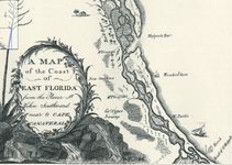
Here are a couple of North Florida wrecks charted circa 1791
- Thread starter Jolly Mon
- Start date
Bum Luck
Silver Member
- May 24, 2008
- 3,482
- 1,282
- Detector(s) used
- Teknetics T2SE, GARRETT GTI 2500, Garrett Infinium
- Primary Interest:
- All Treasure Hunting
I have this:
74-7x-US-FL-1: Captain Magness of the vessel Ann & Elizabeth, arrived in the river bound from Jamaica, on August 8, 1774, saw a large brig on shore to the northward of Cape Canaveral, Florida, and several wreckers stripping her.
References for 1774-7x-US-FL-1:
New Lloyd's List, (London, England), #574, September 24, 1774
Shipwrecks of the Western Hemisphere: 1492-1825, by Robert F. Marx, (World Publishing Company, New York, 1971), p. 220, #102
Probably the northenmost one.
Bum Luck
Silver Member
- May 24, 2008
- 3,482
- 1,282
- Detector(s) used
- Teknetics T2SE, GARRETT GTI 2500, Garrett Infinium
- Primary Interest:
- All Treasure Hunting
There are quite a few documented wrecks in that area, so who knows?
Anyway, the map looks rather "cartoonish", but I will bet there is some historical validity to the listed wrecks.
They all look that way, but I'd guess that they are as accurate as can be expected for the day.
Red_desert
Gold Member
- Feb 21, 2008
- 6,869
- 3,521
- Detector(s) used
- Garrett Ace 250/GTA 1,000; Fisher Gold Bug-2; Gemini-3; Unique Design L-Rods
- Primary Interest:
- All Treasure Hunting
I always find these old Florida maps interesting, just to see them.
bigscoop
Gold Member
- Jun 4, 2010
- 13,379
- 8,708
- Detector(s) used
- Older blue Excal with full mods, Equinox 800.
- Primary Interest:
- All Treasure Hunting
Awesome!
- Thread starter
- #7
In the interest of scale, here is the entire map:
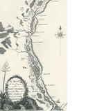
The cartographer was named David Taitt. It is interesting, at least to me, that Taitt worked directly with Bernard Romans on a survey of East and West Florida in 1771-1772. One would think they shared some sources. You have to admit, Romans sure knew his shipwrecks ! I wonder if David Taitt did, too ?
Here is a link to an article on David Taitt. He was quite an interesting character in his own right:Encyclopedia of Alabama: David Taitt
I am sure Taitt's shipwreck symbols are merely formulaic, but you cannot help but notice the exaggerated sterncastles...was he trying to tell us something?
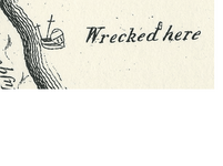 Northern wreck detail
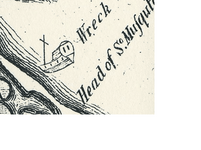 Southern wreck detail
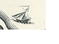
The cutter under sail has a much less prominent sterncastle:

The cartographer was named David Taitt. It is interesting, at least to me, that Taitt worked directly with Bernard Romans on a survey of East and West Florida in 1771-1772. One would think they shared some sources. You have to admit, Romans sure knew his shipwrecks ! I wonder if David Taitt did, too ?
Here is a link to an article on David Taitt. He was quite an interesting character in his own right:Encyclopedia of Alabama: David Taitt
I am sure Taitt's shipwreck symbols are merely formulaic, but you cannot help but notice the exaggerated sterncastles...was he trying to tell us something?
 Northern wreck detail
 Southern wreck detail
The cutter under sail has a much less prominent sterncastle:

Last edited:
bigscoop
Gold Member
- Jun 4, 2010
- 13,379
- 8,708
- Detector(s) used
- Older blue Excal with full mods, Equinox 800.
- Primary Interest:
- All Treasure Hunting
I think I know where the "wrecked here" site is at, I believe it was uncovered during the 2004 hurricane, near 3rd street and high up on the beach. If memory serves me right that wreck was thought to be British by it's construction. Then again with so many wrecks on the east coast might be a different wreck but the location is on target.
The lower wreck is probably the same wreck marked on the Roman's Map. Odd that both maps display the same type "full sail" image in the same location. Also interesting is number of mast on each of the wrecks.
Neat map. I'd like to have a framed copy for the wall.
The lower wreck is probably the same wreck marked on the Roman's Map. Odd that both maps display the same type "full sail" image in the same location. Also interesting is number of mast on each of the wrecks.
Neat map. I'd like to have a framed copy for the wall.
Users who are viewing this thread
Total: 2 (members: 0, guests: 2)
