Maybe it's Not in the Money Pit!

OP
OP
G

gjb

Full Member
Apr 21, 2016
240
307
UK
Detector(s) used
Garrett Ace 300i
Garrett EuroAce
Primary Interest:
All Treasure Hunting
Itā€™s my understanding that there is not 1 pirate treasure map that exists anywhere, ever. The concept of a pirate treasure map is a creation from literature. If we all do our homework, we will eventually all be in agreeement that pirate treasure maps simply donā€™t exist.

As I observed, the map was presented as a pirate treasure map. That was the author's opinion, not mine. The pertinent question is whether anyone, ever, is likely to have produced a treasure map, that is, instructions for locating hidden valuables. From my research, the answer is 'yes'. It doesn't have to be pirates.
 

freeman

Sr. Member
Apr 5, 2003
346
665
I dunno, does this one take your fancy? I don't think you knew or understand how many copies of the map were floating around, not just here but everywhere. I suppose if you did you wouldn't have been trying to figure out something that's already known.
 

Attachments

  • 10436666_375866182599236_5477654773185057647_n.jpg
    10436666_375866182599236_5477654773185057647_n.jpg
    62.4 KB · Views: 147

n2mini

Hero Member
Jan 7, 2015
983
514
Triad NC
Primary Interest:
All Treasure Hunting
but that is assuming they are all the same maps and that these stories are even true. As we all know everything in print isn't true just like most everything dealing with OI....
 

b3y0nd3r

Hero Member
Aug 27, 2011
982
1,172
Detector(s) used
ctx 3030 nokta impact Equinox 800
GJB,

As a firm believer in OI and it's history behind it, I feel your theory may be not with-in the realm of possible and here are my reasons:

Man-hours- The sheer amount of man-hours to do a project of this magnitude would be staggering. There would have to be coordination and such a high level of execution in order to accurately align all the different variables, you would need deep comprehensive intelligence just to conceive it. Most likely this would of taken years to accomplish.

Man-power- How many men would it take to accomplish this? One hundred? One thousand? You are talking moving large stones weighing many tons, coordinating multiple points across the island, all the digging and just the logistics of it, feeding and clothing these people for years.

Keeping it hush hush- There isn't any written accounts of men working to this end. None of the workers passed down what they did, to other people. A complex project like this someone would of bragged about.

Why- The most important question of all is why go through all the trouble to bury or hide treasure.

I prefer to use the available facts to fit a theory.

First, why do I believe the OI story? There were a lot of witnesses saying the same thing. No one embellished on the story and no one tried to change the story for hundreds of years. It has been said eye witnesses are unreliable. But all of them agree and are saying the same story.

So here are the facts as put forth by the witnesses:

A deep pit
A concrete vault
Three treasure chests found
A gold link and parchment found
coconut fiber
box drains
log platforms
blue Clay
island markers/90 foot stone

Here are how those facts fit my theory:

It seemed to me that whoever buried this, didn't want it recovered.

Starting with the original 3, their description of the pit shows great mechanical/engineering knowledge. The platforms supporting the pit from collapse, the clay acting as a shield to prevent surface water from getting down to the lower levels.

Their descendants claim three chests were found. These chests were decoys to stop them from digging further down. The 90 foot stone, was either a warning, a marker, or instructions on what to do next.

The pit was designed to flood using the box drains and the beach was a large man made filter system using massive amounts of coconut fiber. The other markers on the island were either coincidental, or left there as safe guards to deceive or guide away from the pit.

The concrete vault, designed to sink further once the pit was breached past the 90 foot stone, housed whatever was being hid. When it was drilled and the gold link and parchment were found, what they actually found was part of the warning texts, perhaps wrapped in gold chain.

Just my theory.
 

freeman

Sr. Member
Apr 5, 2003
346
665
Well, I can only point out that the claims 'it's not known' or 'we don't know why' or 'it's some mystery' isn't true is it? You can read the above and a simple search of an online newspaper/periodical will provide you many more such details.So you can say 'but, but, but' but when it's there in black and white, when they all used it and are still searching the same spot because it's the same map and you can follow, measure, plot and even see them doing it still then it's not those on the island that are in denial is it? They are just doing what was done from the start and has been reported from the start.

It's those that didn't know this was occurring because quite frankly, the depth of their research never even went as far as opening a newspaper.

Consider that for all those headbanging 'theorists' that turn up claiming the Templars or Incans or Romans were there burying something they can't articulate.
 

Last edited:
OP
OP
G

gjb

Full Member
Apr 21, 2016
240
307
UK
Detector(s) used
Garrett Ace 300i
Garrett EuroAce
Primary Interest:
All Treasure Hunting
Thanks, I get the message, The theory has supporters and detractors. If the supporters owned the island then theyā€™d doubtless test the hypothesis. Detractors wouldnā€™t bother because, knowing the answer in advance, theyā€™ve decided it would be a waste of time.

Well, you canā€™t expect to be able to test every hypothesis. You have to be selective, and the unfailing ability to predict the results of a test inspection and dig, the way some of you can, is a rare skill! You could have saved Rick and Marty a whole load of money!
 

Samanthy

Full Member
Apr 22, 2018
219
251
Phoenix, Arizona
Detector(s) used
Whiteā€˜s Sierra Madre
Whiteā€˜s TMā€“600
Primary Interest:
Cache Hunting
Just out of curiosity, Oak Island is 140 acres in area. Has anyone ever done a GPR Survey of the whole island?
 

somehiker

Silver Member
May 1, 2007
4,365
6,426
Primary Interest:
All Treasure Hunting
Thanks, I get the message, The theory has supporters and detractors. If the supporters owned the island then theyā€™d doubtless test the hypothesis. Detractors wouldnā€™t bother because, knowing the answer in advance, theyā€™ve decided it would be a waste of time.

Well, you canā€™t expect to be able to test every hypothesis. You have to be selective, and the unfailing ability to predict the results of a test inspection and dig, the way some of you can, is a rare skill! You could have saved Rick and Marty a whole load of money!

Have you shared your solution with Rick and Marty, in order to save them money?
If not.....why not ?
 

OP
OP
G

gjb

Full Member
Apr 21, 2016
240
307
UK
Detector(s) used
Garrett Ace 300i
Garrett EuroAce
Primary Interest:
All Treasure Hunting
Have you shared your solution with Rick and Marty, in order to save them money?
If not.....why not ?

Yes, I contacted them soon after they acquired their share of the island and again in 2012 when COOI was being mooted, then again a couple of years back - when I sent them copies of my books and a link to my web site, and I also contacted Prometheus. Of course, you never get in touch with Rick and Marty themselves - I've always dealt with one of the team.

I first came up with the idea in the 1970s and wrote to the island in 1984, but first provided details to Triton Alliance in 1986. I spoke to David Tobias at that time and sent him a summary, but they weren't interested. I wrote to Dan Blankenship a few times but I understand he was in the habit of binning such approaches. I wrote to Fred Nolan perhaps a dozen times trying to explain why it was important to me to talk to him about his surveys. He never replied, and I know I had the correct address.

I'm not sure that investigating the hypothesis now would be easy, because so much has been destroyed. I'd need an original ground marker in its correct position to start off with. I almost begged Triton to be able to attempt to relocate the Mallon Triangle, survey it, document if fully and hand the results to them. They weren't interested. I learnt a few years back that the triangle had been relocated but was in a really poor state and might disappear if not protected. However, nobody has ever considered these markers to be important enough to protect.

Above all, having watched COOI, it seems that those who present proposals don't get a second chance if treasure is not immediately recovered. You'll appreciate that there's far more to the geometry than I've shown and there are alternative scenarios. Sadly, only Rick and Marty have the luxury of testing alternative scenarios. Everyone else must choose correctly first time! Laverne Johnson famously fell foul of this situation with Triton - he was never given a second chance.

So, I no longer hold out any hope. Mine is just one of many such rejected cases, and declining health prevents me now from participating in any investigation, but I reckon I tried!
 

dmg2016

Jr. Member
Feb 8, 2019
28
32
Primary Interest:
All Treasure Hunting
It seems you're referring to the article in Collierā€™s (Sept. 29, 1906) by Josephine Fredea under the title, ā€œThe Lure of the Pirateā€™s Gold.ā€ A guy buys an old manor house, finds an old chest that belonged to a former pirate or privateer etc...According to my contact, the file contained papers pertaining to privateering late in the first half of the 18th century and contained several maps, though they didnā€™t know the identity of the island. It appears that Juan Fernandez was the first choice, but he recalled that his father had been visited by someone from Halifax (which he'd assumed at the time was Halifax in the UK.) After the visit, his father had playfully asked my contact if heā€™d like to go on a treasure hunt.

I agree with you that the map was mostly likely from the late 17th century to the early 18th century. In my opinion, the use of the name ā€œSesambreā€ on the map is pretty telling. From what I can gather, the name ā€œSesambreā€ was primarily used from 1604 (Samuel de Champlain) until about 1730. (ā€œSesambreā€ is now known as Sambro)
 

freeman

Sr. Member
Apr 5, 2003
346
665
Unfortunately again, you all are trying sidestep what is going on. That map doesn't have it origins in Chile, Chile is one of the places a story about it appeared, like the other places it appeared also: Oak island being another. And yes they are using it today on the island to try and hit the position. You won't get an appearance if your work is simply derivative or part of something already known. In your case it's an incomplete idea about some map when everything about it is already known, I mean they are using it still?

And yes it did appear in the story of Guayacan however it also appeared in details of the 'Kidd maps' that were published by a writer called Harold T Wilkins who copied parts from the story and parts of this map. The numbers on the 'kidd maps' that Gilbert Hedden noticed being replicated on the dimensional survey of Oak Island come directly from it.

In facts whole parts were copied from the story: all you need to do is see that 'Cape Blanco' (Cape White) on the 'kidd maps' was a direct copy of the area of 'Playa Blanca' (White Beach) on one of the diagrams for the Guayacan story. I think that part gets told that Harold Wilkins said he must have seen other maps and unconsciously copied parts of them. I mean who the hell would fall for that story?

Hedden didn't go and check, he went to compare the copy of the map he had already with the ones being published in the Kidd stories to explore their source further.

Hedden got his copy in 1934, just when the story of Guayacan came out. Lots of them had a habit of appearing in bookstores.
But of course you did know this?

hedden bookshop.png

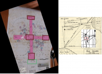
Anyway so you stop going around in circles the 'spot' deemed by the map since the beginning was the intersection of the line bearing and the triangle side.

Here is the latest plotting of the works as they tried to work out this exact position which is proving problematic as the old datum points were moved long ago. The pink upright is from the map grid and the grey bore holes are those following the triangle side line.

You might also like to plot where Borehole 10X is on this map because only the gullible swallowed it was sited by 'dowsing'.

Which part of this are you having trouble coming to terms with they are using this on Oak Island and it's no secret?


marty map.png
 

Last edited:

somehiker

Silver Member
May 1, 2007
4,365
6,426
Primary Interest:
All Treasure Hunting
Yes, I contacted them soon after they acquired their share of the island and again in 2012 when COOI was being mooted, then again a couple of years back - when I sent them copies of my books and a link to my web site, and I also contacted Prometheus. Of course, you never get in touch with Rick and Marty themselves - I've always dealt with one of the team.

I first came up with the idea in the 1970s and wrote to the island in 1984, but first provided details to Triton Alliance in 1986. I spoke to David Tobias at that time and sent him a summary, but they weren't interested. I wrote to Dan Blankenship a few times but I understand he was in the habit of binning such approaches. I wrote to Fred Nolan perhaps a dozen times trying to explain why it was important to me to talk to him about his surveys. He never replied, and I know I had the correct address.

I'm not sure that investigating the hypothesis now would be easy, because so much has been destroyed. I'd need an original ground marker in its correct position to start off with. I almost begged Triton to be able to attempt to relocate the Mallon Triangle, survey it, document if fully and hand the results to them. They weren't interested. I learnt a few years back that the triangle had been relocated but was in a really poor state and might disappear if not protected. However, nobody has ever considered these markers to be important enough to protect.

Above all, having watched COOI, it seems that those who present proposals don't get a second chance if treasure is not immediately recovered. You'll appreciate that there's far more to the geometry than I've shown and there are alternative scenarios. Sadly, only Rick and Marty have the luxury of testing alternative scenarios. Everyone else must choose correctly first time! Laverne Johnson famously fell foul of this situation with Triton - he was never given a second chance.

So, I no longer hold out any hope. Mine is just one of many such rejected cases, and declining health prevents me now from participating in any investigation, but I reckon I tried!

Thanks for your reply gjb. It does sound like you have done all that could have been done with your own ideas, and you should be admired for your perserverance at the least.The problem I have with complex geometric solutions to lost treasure type problems is that there a usually a number of variations to any result of striking lines between multiple points of "possible" reference. In fact, that if just one of those points should go missing, or be altered by nature or man, is also problematic IMO.
 

n2mini

Hero Member
Jan 7, 2015
983
514
Triad NC
Primary Interest:
All Treasure Hunting
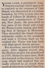
In freeman's article above it mentioned that Hedden electrified the island with submarine cables from the mainland. I'm guessing when they left they pulled these up or why did the Restalls live there for years without electricity?
 

OP
OP
G

gjb

Full Member
Apr 21, 2016
240
307
UK
Detector(s) used
Garrett Ace 300i
Garrett EuroAce
Primary Interest:
All Treasure Hunting
Which part of this are you having trouble coming to terms with they are using this on Oak Island and it's no secret?

I honestly donā€™t know where youā€™re getting all this from. Well, I do, in fact - thatā€™s just a figure of speech - but Iā€™ve always failed to see how such a convoluted theory might hang together or why it should be considered necessary to try to do so. I couldnā€™t see it when it was first presented to me in its infancy some 16 years ago and, Iā€™m sorry, I still donā€™t see it.

I can find nothing in Latchamā€™s work to suggest that the Guayacan pirates had anything to do with Don Juan Esteban de Ubilla or that the map youā€™re using pertains in any way to the 1715 Plate Fleet. Furthermore, one would do well to question the story of the discovery of the Herradura documents and also their authenticity.

I hold a mass of Harold T. Wilkinsā€™ files and correspondence, including letters from Hubert Palmer concerning the Kidd maps, and these documents fail to support anything concerning the pair that youā€™re claiming here.

There are obvious errors in your chronology, and statements unsupported by the primary sources in my possession. As to there being a single source Alpha Map, this is just one of many possibilities. Itā€™s not an established fact, not proven, and shouldnā€™t be declared to be so. Furthermore, the story wrapped around the Alpha Map is pure conjecture, and I still have no idea how such a theory could be tested.

As it is eminently possible that all the episodes that youā€™re attempting to combine are independent of each other thereā€™s a good argument for studying them in isolation. That might suggest how one or two might be intertwined, but it requires a huge stretch of the imagination to believe that they are all interconnected..

Youā€™ve produced no evidence that the early Oak Island investigators were using the Alpha Map as opposed to any other, and youā€™re assuming that the reports of a map being used are true (not journalistic elaboration). If these people did use a map then it would seem that itā€™s now lost to us.

If the current operators are using the Alpha Map to find treasure on Oak Island then I have to admit to being surprised. I was under the impression that any and all treasure maps are out of favour. Treasure maps and Oak Island don't go together - such an idea is food only for the feeble minded! I believe thatā€™s why Iā€™ve had no success in this matter, and I imagine itā€™s why nobody pushing a treasure map will have any better luck.
 

OP
OP
G

gjb

Full Member
Apr 21, 2016
240
307
UK
Detector(s) used
Garrett Ace 300i
Garrett EuroAce
Primary Interest:
All Treasure Hunting
The problem I have with complex geometric solutions to lost treasure type problems is that there a usually a number of variations to any result of striking lines between multiple points of "possible" reference. In fact, that if just one of those points should go missing, or be altered by nature or man, is also problematic IMO.

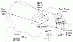
Sad to say, I believe you're right! Hence, the different scenarios, but I'd hoped that recreating the ground plan by survey might reveal additional ground markers, untouched by cowboys and vandals, as confirmation and, potentially, an indication of which way to go.

Here's the problem!!!!

IslandPlan.gif

Note that the mid-point between the Head Stone and Cone D of Nolan's Cross is connected to the centre of the rhombus (indicated by the map points) at a distance of 75 rods. However, the maps suggest that there may be a similar rhombus rectangle to the north-northwest of the original, but on magnetic bearings. The point marked 'North Shore Point' at Joudrey's Cove is a drilled rock in shallow water.

I never said it would be easy!
 

Last edited:
OP
OP
G

gjb

Full Member
Apr 21, 2016
240
307
UK
Detector(s) used
Garrett Ace 300i
Garrett EuroAce
Primary Interest:
All Treasure Hunting
I agree with you that the map was mostly likely from the late 17th century to the early 18th century...

If Iā€™m right about V.R. on the ā€˜Skeleton Mapā€™ standing for ā€˜Vmbra Rectaā€™, most typically from the astrolabe or a similar ā€˜Shadow Scaleā€™, then this would point to much the same time frame. I understand that the astrolabe was in regular use until late in the 17th century, certainly for astronomy and very likely for surveying (theodolites then coming more into use). So, I imagine the term ā€˜Umbra Rectaā€™ might have been used by someone born in the 17th century rather than in the 18th.

In any event, on the same map, the apparent use of the modern symbol for division would seem to point to a date later than 1650. Consider also the implications of the suggestion that there were flood tunnels and a booby trap. If the originator knew that air has weight then the same date applies, and if he had a modern understanding of gases and water under pressure then a date after 1680 would be expected.
 

dmg2016

Jr. Member
Feb 8, 2019
28
32
Primary Interest:
All Treasure Hunting
Do you have any idea as to the origin of the map (English, Dutch, Spanish, etc.)?
 

OP
OP
G

gjb

Full Member
Apr 21, 2016
240
307
UK
Detector(s) used
Garrett Ace 300i
Garrett EuroAce
Primary Interest:
All Treasure Hunting
Do you have any idea as to the origin of the map (English, Dutch, Spanish, etc.)?

I take it youā€™re referring to the map referenced by Josephine Fredea (the story of a map found in an old chest, the possession of a former mariner / privateer etc.)

If so, it's probably worthwhile quoting the paragraphs most relevant to your question:

ā€œHe [the person finding the map] was immediately struck by its remarkably similarity to a certain island clearly indicated on the chart in his possession. Between this island, ā€˜past Sesambreā€™, as it is written on the chart, and a certain islet in the West Indies, there is marked a clearly defined track; and although most of the writing thereon is in Spanish and Dutch, yet it is apparent at a glance that there was a well-travelled path between them.

Other papers show that a removal and subsequent deposit of seven separate packages took place on certain dates, each package bearing separate symbols and initials.

There is also a diagram of the Cove on Oak Island, in the form of a Dutch tobacco pipe, and to this diagram is attached a paper which has not been easy to decipher.ā€

As noted in a previous post, Sesambre is now Sambro Island at the entrance to Mahone Bay.

I discuss the implications in my book, but it should be noted that a number of observations are ahead of their time: the suggestion that thereā€™s more than one treasure and that there were originally two islands.

I find it strange that there was a track between an islet in the West Indies and one in Nova Scotia! My suggestion is that one of the islands was named, and this is also the name of an islet in the West Indies. It may even be that the name actually applied to both islands.

You may appreciate that the island of Tortuga was named for its resemblance to a turtle swimming (from afar, a small head and a larger body separated by water). Close up, the two islands are not actually separated. Could it be that Oak Island was once named 'Tortuga' for the same reason? There being a track between the two islands suggests that in reality it's one island with a bar connecting two prominent parcels of land.

Note that on the Skeleton Map there's a strange observation ā€˜20 Turtles'. What if the ā€˜20' has nothing to do with the turtles (I suggest itā€™s actually a point - an open dot - marked by the Greek letter gamma) and that ā€˜Turtlesā€™ is a translation of ā€˜Tortuga(s)ā€™, the name of the island, or islands?

Maybe we now call it Oak Island!
 

Last edited:
OP
OP
G

gjb

Full Member
Apr 21, 2016
240
307
UK
Detector(s) used
Garrett Ace 300i
Garrett EuroAce
Primary Interest:
All Treasure Hunting
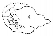
Just to round things off concerning the maps, and to close the thread so we can all to move on to more important things, below is the island outline, from Harold T. Wilkinsā€™ book Captain Kidd and his Skeleton Island, to which the instructions on his maps actually apply.

JohnSmap.jpg

Wilkins attributes the map to pirates, referring to it as John Sā€™s Map, and asks his readers, ā€œWhere is this island?ā€ Simply reducing the outline along the 'y' axis reveals its identity.

JohnSGloucs.jpg

IMO itā€™s clearly Gloucester Isle from Des Barresā€™ Atlantic Neptune, so it seems we now know that the instructions on Wilkinsā€™ maps originally pertained to Oak Island. Note the common features: the inlet at northwest and the ā€˜bulbā€™ at east, also the two ā€˜riversā€™ on both.

Obviously, no big deal, as thereā€™s no treasure on Oak Island and the maps are fakes!

So, why might there be two letters ā€˜Xā€™, a small one above large, at the centre of the island bearing from NE to SW? It looks like they might pertain to Nolanā€™s Cross. The map was published some 60 years before Nolan's Cross came to light.

On the Skeleton Map there are two points marked on the shoreline at what are described as the ā€˜Anchorageā€™ and ā€˜Smugglerā€™s Coveā€™. With the map aligned for the instructions (rotate so East is at north), these would likely be Smithā€™s Cove and Joudreyā€™s Cove respectively, each of which has a prominent boulder on the beach. Maybe it's useful to know these exist, perhaps as pointers.

But, no big deal, because if itā€™s not on The Curse of Oak Island then it canā€™t be relevant!

Thanks for your interest and discussion.
 

Last edited:

Top Member Reactions

Users who are viewing this thread

Top