Pipsico Hunt - Camp Kiwanis Arial

Kiros32

Bronze Member
Feb 21, 2006
1,407
441
Pittsburgh, PA
Detector(s) used
XP Deus, Whites MXT
Primary Interest:
All Treasure Hunting
This is where we will be camping/hunting at the Pipsico Hunt. Everyone take a look and see if you can see anything worth checking out. Apparently there was an old road either between camp 7 and 8, or on the east side of 7. From what I have heard, this should be an awesome hunt!!!
 

Attachments

  • Camp Kiwanis.JPG
    Camp Kiwanis.JPG
    229.4 KB · Views: 469

LadyDigger

Bronze Member
Jun 7, 2006
2,188
51
Virginia Beach
Detector(s) used
Garrett Ace 250
Kiros,

Talked to Ranger Dan today....and he confirmed the old road I mentioned in the thread for the hunt coming up.

I was looking at the map earlier and something does catch my eye....just above where you typed in "7"...look along the current road and to the right...do you see another road??? 
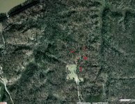
It comes up from where you typed in "7"?...or am I just seeing things? If that is a road...you think it could be part of that old road? Ranger Dan also said that from the campsite area...that road is hard to get too????

Also....he said that they have hunted and hunted and can not locate where Erasmus Carter's homestead was, no foundation to be found :(...and if we want, we can rake some brush/leaves out of the way...as long as we brush it back where it was! I'll bring some rakes!

Funny too...I printed all those pics out....snagged them and printed as I was going to sit here and really look for anything different! Funny how we went to the same site! LOL :)

(PS: it's all tent camping too..no buildings...but we can use the OA Shelter ...which is outside, but has a fireplace we can use as long as we clean it prior to leaving!!!...it's gonna' be cold. Ranger Dan said they have already had a few nights where the morning saw FROST!!! BRRRR!)

I also noticed some clearings along Kiwanis Road..the road we take to camp...might be something to look at too!

Where you able to find anything else?
Annmarie

PS: also note...to the left of Campsite 9..where we will be camping at...that field you see..that was all once cornfields!!! Would anyone be able to give a rough estimate about where a homestead would be? I am thinking around campsite 6, maybe around 7 or 8....but just below the field is campsite 1 and it's possible it could have been there. Keep in mind the old road also...this old road was used when they took supplies to the river to be loaded...we will be in search of hopefully, foundations for a brothel, post office and general store and I believe one or two other buildings, near the river bank.
 

DCMatt

Gold Member
Oct 12, 2006
10,367
13,503
Herndon Virginia
Detector(s) used
Minelab Equinox 600, EX II, & Musketeer, White's Classic
Primary Interest:
Metal Detecting
Here's an 1888 comparison of the same area. Obviously the scale is not the same but you get the idea...

Note that the road back then came from the east-southeast into what is now the camp area. It makes sense to me that a house would have been along the road - possibly at the point where the road turns towards the river in the clearing. This assumes that the 1888 road is "original". By 1915 the road comes into this area from the south-southwest (according to maps I've seen).

If the topo on the old map is accurate, the two rises shown in the clearing should be easy to find. What say ye?

If anyone is interested, the 1888 & 1915 maps are available online. PM me for the URL.

pipsico.jpg


DCMatt
 

LadyDigger

Bronze Member
Jun 7, 2006
2,188
51
Virginia Beach
Detector(s) used
Garrett Ace 250
Hey DC...

You gonna' make the hunt in a couple of weekends with us?

I figure the house has to be along the road (old one) near the cornfield though...wouldn't you think? I just don't know what they would have considered the "front" or "back" of the cornfield....:)

Hubby was told the old road was either between 7 and 8 or just beyond 7 facing the river side of the campsite. He said he didn't get a chance to check it out and Ranger Dan told me yesterday that it would be hard to get to now...

BY THE WAY: He did inform me the COPPERHEAD are asleep!!! :) ;D ;D ;D...but Mother Racoon (the one with the PH'd in FOOD COOLER OPENING)...is still lurking!!!

I'm getting real excited about this one .... and I think with alot of the foliage down now...we should have a better time hunting and possibly finding an old foundation somewhere!!!

I just don't think the house would be near the river though...if the brothel, general store, post office and other buildings were to be there....but then again, until we find the actual location of these buildings, we just don't know.

I could have sworn I read in the BSA Museum up there, that the general store and post office was right along the road at the front of the camp....I will have to go through my paperwork again and see where I read that. It may be in a photo I took at the museum (the info)!!!

But there were buildings at the river front, due to the shipping and places for the "sailors" to stay and eat and such....at what was known at Dillard's Wharf. After looking at the map again, the one you posted, that very well may be on BSA Land and not Eastover as I originally suspected. I know the property line for BSA and Eastover is the swamp, according to the BSA Map on their site. (Correction: I always get confused on this EASTOVER location).

If you are standing at the front of the BSA Reservation looking towards the river...EASTOVER is on the left of the land of Pipsico and to the right, where BROAD SWAMP is....is what is still commonly known as FOUR MILE TREE, based on an 1983 map I located at TOPOZONE, which shows the location of DILLARDS WHARF...which from this TOPO MAP...shows it to be on BSA LAND!!!! The boundaries for BSA and FOUR MILE TREE area is center of the swamp.

Hope we see you up there...told Ranger Dan I will be there between noon and 4 pm...as I want to get there before dark on Friday!!!
Annmarie
 

DCMatt

Gold Member
Oct 12, 2006
10,367
13,503
Herndon Virginia
Detector(s) used
Minelab Equinox 600, EX II, & Musketeer, White's Classic
Primary Interest:
Metal Detecting
Annmarie,

I hope to make it to the hunt. Also hope to bring my local MD buddy with me. Sure wish I could get "boots on the ground" for a day before the hunt. That's a lot of rough territory to cover...

I downloaded a high-res version of the 1888 map. It shows buildings in the area as solid black dots. 8 - 10 buildings at Four Mile Tree are clearly visible. Also at Eastover. The location of the Dillard house (IMO) is just barely off this map - south & west of the camp area. I think it is shown on the 1915 map.

I agree that business structures would have been closer to the river and away from the house.

On the map there are two solid black dots right along the river just down river from Dillard wharf. I'm not sure if these are indications of two buildings or not. Modern topo maps show the area as low land or swamp. In some ways it makes sense to put a store and a juke joint there. In others ways, it doesn't make much sense at all. I won't get into my reasoning... Too long... Pretty sure that area is Four Mile Tree land anyway...

If I do make it, I'll probably spend my time looking for the Dillard house. The old road just looks too rough to cover in the time we have.

DCMatt
 

Top Member Reactions

Users who are viewing this thread

Top