Problems with Google Earth am I doing something wrong

john37115

Hero Member
Nov 8, 2007
529
3
Tennessee, USA
Detector(s) used
E-Trac, F75, Nautilus dmc IIb, Custom Soveriegn, Pro XL, Classic IV, IDX, Compass Gold Scanner Pro
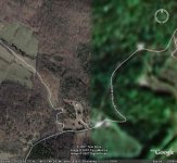
I downloaded Google Earth onto my desktop. It's great I can see alot of areas clear as a bell EXCEPT for the counties I hunt in They look Dark green and extremely blurry if you try to zoom in. It's like a straight line about 20 miles from me that goes from North to South. Clear on one side and blurry on the other. I'm puzzled, any suggestions?
 

Attachments

  • GOOGLE IMAGE.jpg
    GOOGLE IMAGE.jpg
    75.9 KB · Views: 567

KenPa

Hero Member
Apr 7, 2006
873
1
Easton, Pa.
Detector(s) used
Whites XLT
John you are not doing anything wrong. Some areas on google earth are clearer than others. You may want to try Flash earth or yahoo maps. Even Mapquest has areal views which are pretty good. They all seem to have more detail in certain areas though. I like Flash Earth because when you get to the area you are looking at there are several servers on the same site and some are clearer than others.
 

River Rat

Super Moderator
Staff member
Jan 6, 2006
20,846
2,532
SE Louisiana
🏆 Honorable Mentions:
1
Detector(s) used
Garrett AT Pro, Ace 250 & Ace 400
Primary Interest:
All Treasure Hunting
Hey John,

Google Earth is not in the "wilderness" of the rural areas. I have that same problem too. I can zoom in all around the area till you hit the swamps heading towards my local towns & it looks just like your pic. Tell you what, try Map Quest.Com type in the address/street/road/town then click "aerial". Believe me, I can see everything on our property, including the cattle grazing in the pasture, the trails in the woods, etc.

;) RR
 

shanegalang

Bronze Member
Oct 31, 2007
1,379
641
Island of Mozambique
🥇 Banner finds
1
🏆 Honorable Mentions:
1
Detector(s) used
XP DEUS, X 35 coil, 11" LF coil, Deteknix headphones with WS4 puck, Fiskars steel D-Handle Transplanting Spade
Primary Interest:
Other
The geological survey uses aerial photographs in most rural areas that you see on google. They suck I know but that's just how it is. I have noticed that most more populated areas such as cities seem to be actual satellite images. I could be wrong but I think the ones that aren't so clear are actual photos taken from an airplane.
 

OP
OP
john37115

john37115

Hero Member
Nov 8, 2007
529
3
Tennessee, USA
Detector(s) used
E-Trac, F75, Nautilus dmc IIb, Custom Soveriegn, Pro XL, Classic IV, IDX, Compass Gold Scanner Pro
Thanks guys. I looked at mapquest, flashearth and terra server. They all seem to be dated maps. It would be nice to get the satelite image from google earth but I guess the others will have to do. :-\
 

Shortstack

Silver Member
Jan 22, 2007
4,305
416
Detector(s) used
Tesoro Bandido II and DeLeon. also a Detector Pro Headhunter Diver, and a Garrett BFO called The Hunter & a Garrett Ace 250.
Primary Interest:
All Treasure Hunting
Try "World Wind" . It gives you the choice of different maps, different satalite-source photos, etc.
 

EDDE

Gold Member
Dec 7, 2004
7,129
65
Detector(s) used
Troy X5
Primary Interest:
All Treasure Hunting
Terraserver also is good

GOOGLE EARTH SUCKS don't bother with the pay service either
 

garym94931

Jr. Member
Jan 21, 2008
29
0
i was one of the original purchasers of google earth when it was still known as keyhole. then google bought it and its been upgraded regularly since. i'm not sure if people can buy into the accounts any longer but i'm very happy with what i see. but as has been said here, they upgrade their photos every couple of years but mostly in urban areas. but as i pointed out on another post, it still is more effective for me than national geogrpahic topo software... i can clearly see trails on google earth that do not show on NG topo.
 

Top Member Reactions

Users who are viewing this thread

Top