Recent dredge puts iron/pottery on the island!!!

ivan salis

Gold Member
Feb 5, 2007
16,794
3,809
callahan,fl
🏆 Honorable Mentions:
1
Detector(s) used
delta 4000 / ace 250 - used BH and many others too
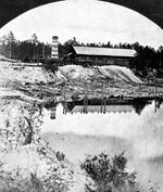
the high ground would be the logical site for camp sites to be without a doubt --due to sudden rain storms and flooding -- camping on the high ground was a must --if you were not on the high ground you got soaked by the run off from the higher levels as well as the normal rain -- on high ground you got the basic rain but not the run off.---- when looking for camp sites seek the highest ground in the area with a nearby fresh water source ---Ivan
 

OP
OP
RELICDUDE07

RELICDUDE07

Bronze Member
Oct 2, 2007
2,128
54
Pascagoula Ms.
Detector(s) used
minelab exp.
Thanks jason for the cleaning tips.Im just glad it wasnt a rare coin,and then me screw it up...Im going today to get the bolt and cleaning supplies.And thanks ivan,we are going to start at the end/lake and work are way back down the island.No one at the end and alot of things in that area....Its a hard place to search we have no maps of any structures that show anything at this place ,but we know they were out there from the artifacts...
 

Chagy

Bronze Member
Dec 20, 2005
2,226
121
Florida
Detector(s) used
JW Fishers Pulse 8X
Primary Interest:
Shipwrecks
RELICDUDE07 said:
Some crap in there too :D Just one more thing.If you guys were looking for treasure on this island,would you start at the high ground /bluffs oak tree clusters for the shade in the summer time.Nice and cool or would you start at the lake ,at the end of the island?

Dude,

I tuck a closer look with the bird's eye on vitual earth and I marked in red the areas that look as there has been an structure in the past and in green the areas where I would also hunt......That just my humble opinion...I'm sure Pcola has already done this...

Chagy....
 

Attachments

  • relic island.jpg
    relic island.jpg
    94.1 KB · Views: 702
OP
OP
RELICDUDE07

RELICDUDE07

Bronze Member
Oct 2, 2007
2,128
54
Pascagoula Ms.
Detector(s) used
minelab exp.
Thanks chagy for the help. Im going to hit those places hard. I also like the cluster of trees, pcolaboy went in them about 2 weeks ago,and the brush thick :o 
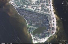
But looks like a great spot ,high ground at the end of the island...I will stay in touch....
 

pcolaboy

Hero Member
Sep 5, 2006
916
14
Pensacola, Fl
Detector(s) used
Minelab Explorer XS
Ok a bit of new information I got down at the Pensacola Library today. The following information appeared in the very first edition of the newly created Pensacola Gazette on March 13, 1824.

John Innerarity was mentioned as being the attorney and executor of a man's estate during the sale of the man's home. Then coincidentally, there is another legal notice on the same day regarding the transaction of 800 arpents (640 acres) of land and sawmill called "Love's Mill" on the Perdido River (Perdido Bay was also called Perdido River for quite sometime). Innerarity's Land Grant claim was for exactly 640 acres also so I think it's reasonable to assume this is the same tract of land being discussed BEFORE Innerarity received it. Here's the exact text that was listed in the paper:

1. JOHN INNERARITY, atty., executor for heirs of VINCENTE ORDOSGOITTE, decd. MACOS TIO and all others con-cerned are to take notice. A house and lot situated between DR. MANUEL GARCIA & ANNA MCVOY will be sold. Published on behalf of JUAN MALAGOSA by his attorney, JOSEPH M. WHITE;

2. Mr. ALEXANDER LOVE, atty., ELIZABETH BRINSON and JAMES DEAN. This deals with 800 arpents of land and sawmill called LOVE’S MILL located at Pensacola on the Perdido River; and ½ lot #6 (with a house on it) in Pensacola. Published on behalf of THOMAS ENGLISH by his attorney JOSEPH M. WHITE.


It's getting pretty interesting....I'd be willing to bet that the marshy area with the fairly purpose-built canals was a log pond for the old sawmill. Looks like I'm going to have to dive in there to find some evidence :o YUK! In case you're wondering, log ponds were used to easily float the logs into the intake poriton of the sawmill and were not subjected to currents, tides, etc. It makes complete sense to me especially with all the canals that would be used to move logs from the bay and into the main pond in the center.

Pcola
 

Chagy

Bronze Member
Dec 20, 2005
2,226
121
Florida
Detector(s) used
JW Fishers Pulse 8X
Primary Interest:
Shipwrecks
All the things in the pic with the red background were found in the same area?
 

OP
OP
RELICDUDE07

RELICDUDE07

Bronze Member
Oct 2, 2007
2,128
54
Pascagoula Ms.
Detector(s) used
minelab exp.
Did you get that?Yes they were all the same place, and the same day ....Pcola ?when do you think this sawmill was built?Any maps on the area?
 

pcolaboy

Hero Member
Sep 5, 2006
916
14
Pensacola, Fl
Detector(s) used
Minelab Explorer XS
RELICDUDE07 said:
Did you get that?Yes they were all the same place, and the same day ....Pcola ?when do you think this sawmill was built?Any maps on the area?

I'll see what I can dig up - no pun intended. When I worked at the Paper Mill we used to take our computer backup tapes to the old forrestry office vault. You would not believe the enormous amounts of original land records and deeds in there going all the way back to the Spanish period. I'll see if I can get my former coworker to let me in there one afternoon this week so I can snoop around. As far as a date goes, it's pretty certain that the sawmill was already there for some time before Innerarity was "granted" the land in and around it. Some of this just doesn't add up..but then again that makes it all the more exciting ;D. Oh by the way, besides Pierre, Lafitte's other brother's name was Alexander :o
 

Chagy

Bronze Member
Dec 20, 2005
2,226
121
Florida
Detector(s) used
JW Fishers Pulse 8X
Primary Interest:
Shipwrecks
No I didnt....to fast ;D

Then you need to stay in the area were you found the stuff.......Bro, that lock plate has my head spining :icon_scratch:
 

OP
OP
RELICDUDE07

RELICDUDE07

Bronze Member
Oct 2, 2007
2,128
54
Pascagoula Ms.
Detector(s) used
minelab exp.
I know ,i caint really tell how old the lock plate is.....But it looks late 1700s to me..Pcola what doesnt add up? What ever happend to the ineraritys son named jean born sept. 26 1780? Poor guy is a lost soul :D
 

Chagy

Bronze Member
Dec 20, 2005
2,226
121
Florida
Detector(s) used
JW Fishers Pulse 8X
Primary Interest:
Shipwrecks
Pcola, could this be it......

Boom and sawmill in or near Pensacola picture
 

Attachments

  • n032465.jpg
    n032465.jpg
    106.2 KB · Views: 637

pcolaboy

Hero Member
Sep 5, 2006
916
14
Pensacola, Fl
Detector(s) used
Minelab Explorer XS
RELICDUDE07 said:
I know ,i caint really tell how old the lock plate is.....But it looks late 1700s to me..Pcola what doesnt add up? What ever happend to the ineraritys son named jean born sept. 26 1780? Poor guy is a lost soul :D

All I know is that our John Innerarity was actually John Innerarity, Jr. and was born in Scotland in 1780 - the son of John Innerarity, Sr. Jean is french for John and of course Juan is spanish for John. Our Innerarity was called all of those names depending upon the nationality of the person referring to him.

What I meant by it doesn't add up is that....the Spanish permanently turned over Pensacola and all of Florida to the U.S. in 1821. Therefore any official "land grant" would have to occurred in 1821 or earlier. There is the possibility that Innerarity leased the land to the sawmill guy as the newspaper article from 1824 seemed to indicate ownership. The other odd thing is that the 1825 survey map that I sent you the link for doesn't detail any sawmill at the end of the island - but maybe it wasn't required? There's no telling what kind of wrangling was going on to snatch up land and claim that it was granted by the Spanish. Afterall, Innerarity's profession was as an attorney.

We'll find out for sure pretty soon.

Pcola
 

pcolaboy

Hero Member
Sep 5, 2006
916
14
Pensacola, Fl
Detector(s) used
Minelab Explorer XS
Chagy said:
Pcola, could this be it......

Boom and sawmill in or near Pensacola picture

It would certainly look similar to that. If memory serves, that picture is of a sawmill in Barth or Molino which is just north of Pensacola.
 

OP
OP
RELICDUDE07

RELICDUDE07

Bronze Member
Oct 2, 2007
2,128
54
Pascagoula Ms.
Detector(s) used
minelab exp.
keep diggin at it pcola we may unlock something good ;D 6. i. JAMES3 INNERARITY, b. August 18, 1777, Aberdeen, Scotland; d. October 3, 1847.
ii. BARBARA INNERARITY, b. March 6, 1779, Aberdeen, Scotland.
iii. JEAN INNERARITY, b. September 29, 1780, Aberdeen, Scotland.
iv. HENRIETTA INNERARITY, b. May 1, 1782, Aberdeen, Scotland; d. July 28, 1833.
v. JOHN INNERARITY, b. November 11, 1783, Aberdeen, Scotland; d. July 28, 1854, Pensacola, Escambia, Florida.
All blood ties to willam panton Among the loyal traders who transferred their
headquarters to St. Augustine, was the firm of
Panton, Leslie and Company, the principal part-
ners in which were William Panton, John Leslie
and Thomas Forbes, all related by ties of blood
and business. Panton had already, or soon after,
secured the close friendship of a rising young half-
breed chieftain of the Upper Creeks, named Alex-
 

pcolaboy

Hero Member
Sep 5, 2006
916
14
Pensacola, Fl
Detector(s) used
Minelab Explorer XS
Did you also notice the name of the street where we parked that day we walked out there? Red Cedar Street. If this was a predominantly cedar mill, then there is a good chance of finding an intact waterlogged cedar log in the pond as they were known to sink if they remained in the pond too long. Cedar lasts a pretty long time submerged under water and mud.
 

pcolaboy

Hero Member
Sep 5, 2006
916
14
Pensacola, Fl
Detector(s) used
Minelab Explorer XS
RELICDUDE07 said:
keep diggin at it pcola we may unlock something good ;D 6. i. JAMES3 INNERARITY, b. August 18, 1777, Aberdeen, Scotland; d. October 3, 1847.
ii. BARBARA INNERARITY, b. March 6, 1779, Aberdeen, Scotland.
iii. JEAN INNERARITY, b. September 29, 1780, Aberdeen, Scotland.
iv. HENRIETTA INNERARITY, b. May 1, 1782, Aberdeen, Scotland; d. July 28, 1833.
v. JOHN INNERARITY, b. November 11, 1783, Aberdeen, Scotland; d. July 28, 1854, Pensacola, Escambia, Florida.
All blood ties to the willam panton family

Oh so there was a Jean in addition to John...my bad...I didn't catch on to that. Good job! Now was that a male or female? ???
 

pcolaboy

Hero Member
Sep 5, 2006
916
14
Pensacola, Fl
Detector(s) used
Minelab Explorer XS
RELICDUDE07 said:
John owner of the islands mon is henrietta panton the 1st, sister of willam panton.....

Ok so you want to head out there Thursday afternoon in my boat? I should be able to pull us up to thigh deep water before needing to anchor. We're definitely bringing the MD's and a damn machete this time. Feel free to invite Mike to come along if you want. I also want to check out that wreck we found while sidescanning further up the bay. Hopefully we won't get hit with another squall while in the boat like last time. ;D

Pcola
 

Chagy

Bronze Member
Dec 20, 2005
2,226
121
Florida
Detector(s) used
JW Fishers Pulse 8X
Primary Interest:
Shipwrecks
History of Innerarity Island

and its Development


Much of history is based on our speculation and popular theories. Much of our history occurred long before it could even be written down. Much of our island's history is only recorded in people's minds and hearts. Let us now go as far back as we can, to the time the American Indians roamed these lands and plowed these waters and even before they were called American Indians.

The nomadic Indians traveled up and down the major rivers and waterways, staying further north during the hot summers and enjoying winters in what we now call paradise on the Emerald Gulf Coast. Some tribes came to the Gulf Coast all the way from the Great Lakes, others just coming down from Northern Alabama. Wherever their summer home, these early snow birds made their way to Lost Bay, now called Perdido Bay. They fished the waters near what became to be known as Innerarity Island. They cooked on the island; but they buried their dead across the bay near today's Mill Point and Bear Point. As modern houses were built on Innerarity Island, the utility line and foundation digging would frequently unearth oyster shells, sometimes mountains of them giving us a clue on how the Indians lived on our island. Even today, there are undeveloped portions of our island that contain the remains of cooking areas using pit ovens and mounds and cleaning areas with the remaining shells just beneath the ground foliage. The south shore, protected from the prevailing winds from the north during the winter, was a favorite for the Indians.

The first American settlement was in Pensacola around 1559; but it was lost within a few years. That is why St. Augustine is given the title of the first "continuous" settlement in America. The Spanish were settling in Pensacola and the French occupied Mobile. Neither side were friendly but neither side wanted to sustain causalities and losses in an armed conflict. Perdido Bay became a de-militarized zone (DMZ) which left the Indians as the sole occupants.
In those days, Perdido Bay had actually two narrow mouths into the Gulf and was clogged with wetlands and fresh water marine growth so the access was almost invisible. The Indian name given to Perdido Bay was Lost Bay for its illusiveness. Freshwater would flow down Perdido River and almost to the Gulf before being mixed with saltwater. In 1693, a Mexican cartographer and scientist, Don Carlos Siquenza recorded finding the entrance to Perdido Bay from the Gulf in the vicinity of today's Flora-Bama Lounge and 3 miles from the current Alabama Pass. As our area again became settled in about 1719, fishermen found the shores of Innerarity Point peninsula attractive. The Point was close to the route to the Pass to the Gulf, at that time, being south past Ono Point, down Ole River between Ono Island and Perdido Key, neither of which were then islands, and out into the Gulf. There is no evidence that our island was ever occupied by the fishermen. After all, it was an island isolated from the mainland.

In 1802, John Innerarity came into our area with his grandfather who moved his trading company from St. Augustine to Pensacola. John Innerarity spoke 9 different languages including some of the Indian dialects which were invaluable in trading with those Indians. Innerarity would go into the forests for 6 months at a time and then return with many goods and products that were craved by the Spanish. The first Spanish Land Grant for Innerarity Island was given to Ygancio Serra. A condition for permanent title to this land was to being in a crop. When this condition was not met, the Land Grant was lost. In 1815, the Spanish Governor rewarded Innerarity with several land grants including the island and peninsula that bear his name today. These land grants were not meant for homesteads but for their natural resources like timber.

At the same time, the notorious pirate, John Laffite, came into the area. In fact, Laffite was born in the same year as Innerarity, came to the Gulf waters at the same time, would disappear for 6 months at a time just like John Innerarity. Laffite was a better manager of trading goods than he was a mariner; Laffite had as many as 10 pirate ships under charter so he could focus on trading his captured prizes. During the war of 1812, Laffite helped Andrew Jackson defend the City of New Orleans from attack by the British. Later John Innerarity enjoyed lavish rewards from the hands of the new Governor of Florida, the same Andrew Jackson.

Could these two men, John Innerarity and Jean Laffite be the same man? Maybe. According to the only remaining Society of Jean Laffite there is no evidence to refute this theory. It is possible. John Innerarity settled down and lived full time on our island around 1821, the same time Laffite disappeared off the coast of Honduras under mysterious circumstances. His grave was never known. John Innerarity didn't die until 1854; his grave is in St. Michael's Cemetery in Pensacola.

In the early 1800's the Navy placed a boatyard on the tip of what is today Allegany Point, the first phase of today's Naval Aviation Station. The purpose was to build and maintain the wooden vessels the Federal Government was using to slow or stop the slave trade coming into the ports along the Gulf Coast. The location of the shipyard was made attractive because of many stands of live oak trees. The Navy actually planted more trees along present day Gulf Breeze but the trees on Innerarity Island and Innerarity Point were probably natural.

The pass to the Gulf was long and narrow during these days. Fishermen would spend long hours just getting into the Gulf to start making their living catching fish. Sometime after the end of the Civil War, the Weekly Brothers, more as a lark, tied a "slip pan" or plow to a mule and drove him across the land mass that connected Ono Island and Perdido Key with Bear Point and created a shallow ditch. The theory was that once water started flowing through this ditch that ran now from Perdido Bay to the Gulf of Mexico, that the currents from the tides and the fierce storms would widen and deepen this ditch into a manageable channel that would allow quicker access to the Gulf and give the fishermen more time to fish. That was the beginning of what is now the Alabama Pass of today. By 1918, the water depth was only about 4 feet.

Skipping ahead to the next century, the Navy used Perdido Key and Ono Island for target practice prior to development in these areas. Even today, unexploded ordnance is occasional found buried in the shifting sand. There is no evidence that the trees and foliage on our island were ever at the aim of these important training missions.

Around 1880, a logging operation was active along the Perdido River with the logs being floated down to mills across from Lillian, Alabama. A shallow manmade cut was also created across the connection going out to Perdido Key but would have been a constant challenge to keep open. Around 1915, a logging operation was begun on Innerarity Island and eventually a mill was put on the island. This necessitated the construction of the first land bridge to connect the island with Innerarity Point. The causeway would have been very rough compared to today's land bridge, only a single dirt lane for the horses and wagons going across. It took 19 more years before the portion of the road on Innerarity Point was finally improved and paved. The lumber mill was probably located on the western end of our island where some old maps still show a structure's foundation which has long since been lost in the wetlands and shifting sands. Today's aerial pictures show ponds and canals that could have been used for this lumber mill.

In 1929, Alabama and Florida saw a need to cross the water from Orange Beach over to Escambia County. Land was bought for the bridge starting on the Alabama side near Bear Point and hopefully passing onto our island and then extending along Innerarity Point and onto the mainland. A company was issued a charter for either building the bridge or starting a ferry service. The ferry service lasted only 3 weeks before closing for the lack of customers. In the 1950s Alabama took over the sole responsibility of building the bridge over Alabama Pass after getting Florida to agree to give the rich tax based Ono Island and part of Perdido Key to Alabama. The first bridge was constructed in 1963 and then the Pass was dredged allowing salt water to encroach well up into Perdido Bay.

The uncertain land tie between Innerarity Point and Perdido Key was severed during the 1930s when a WPA project dug the Intracoastal Waterway using a bascular bridge to get over the waterway and onto Perdido Key. Tow boats hated that inconvenience and would reportedly hit the bridge regularly to knock it out of commission. Today a high fixed bridge replaces the old bascular bridge but the road approaches to the original bridge can still be seen.

Development of Innerarity Island began in the late 1960s when Hamilton Kenner put in a short road along both the north and south shores of Innerarity Island. A few houses were built but records aren't very accurate on where or when. Around 1970, another land developer, Ben White, who also developed the Grande Lagoon residential area, expanded the development on the island. Land restrictions were first documented in 1971 thru 1976 by Mr. White. The first house to be documented was built in 1973 on Innerarity Circle although some remember houses on the north shore even before Mr. White's ownership. Because of very high interest rates during the early 1980s, Ben White was forced into bankruptcy. His accountant, Fayette Dennison, bought the island and actively continued its development. Today, Mr. Dennison still owns the largest number of lots on the island.

Today there are almost 600 home sites on the island, including the Russell Bayou development. There are three property owner's associations, Innerarity Island Association, Russell Bayou, and Sundance for the town homes. Not counting these town homes, there are currently 159 homes as part of Innerarity Island Association and 23 more in Russell Bayou.

During the 1970s and 1980s, 92 homes were built on the island. In 2001, 4 more were added; in 2002, 8; in 2003, 9; in 2004, 15; in 2005, 12; in 2006, 13; and in 2007, there are 6 expected to be finished. Russell Bayou added all their 23 homes in recent years. Lots with houses are increasing at a rate of about 10% per year; so the island should be mostly built up in another 10 years.

http://www.innerarityisland.net/2-History of Island.html
 

Top Member Reactions

Users who are viewing this thread

Top