BosnMate
Gold Member
- Sep 10, 2010
- 6,916
- 8,441
- Detector(s) used
- Whites MXT, Whites DFX, Whites 6000 Di Pro
- Primary Interest:
- Other
Anyone that has read stories of the westward expansion has read about the wagon trains crossing the Continental Divide at South Pass. A few years ago on a trip to Denver, I made a point of turning off I-80, going way out of my way, heading over to the actual pass where the wagons crossed. I-80 crosses the divide twice, heading east it crosses into the Red Desert, which is a basin with no outlet to any ocean, cross the dessert and go over the next divide onto the eastern draniage. Travelers on the Oregon Trail heading west, left the Platte river, and followed up stream on the Sweet Water River, (actually a decent creek) then crossed over the divide and followed Pacific creek down stream to the Green River. Anyone interested in finding additional information on the pass, click on this link.
South Pass (Wyoming) - Wikipedia, the free encyclopedia
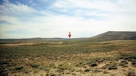
I was traveling east when I took this picture. South Pass is a broad, open plain, with the Wind River Range to the left, and Pacific Butte is on the right, then out of the picture there's Oregon Buttes and the Rocky Mountains continue south.

Just pass the divide, on the west slope, the trail split. One branch continued on to the Green River, then to Fort Bridger and split again, either for the California gold fields, or on to Oregon. The next photo is the cut off trail to Fort Hall, Idaho, then on to Oregon.

I didn't have time to explore that trail, so I left the paved road, and headed over toward the divide. I continued on a dirt road that followed the trail for a couple of miles I guess, and arrived at a cluster of buildings at Pacific Springs, which I suppose feeds Pacific Creek. Off to the left out of the picture is a beautiful meadow full of lush green feed. I expect that area was fed down to dirt when the immigration was going on. I don't know if this qualifies as a ghost town, but I'm sure it was a stage stop and probably saw a lot of activity freighting before the railroad came through.


From here is was a short distance to the divide.

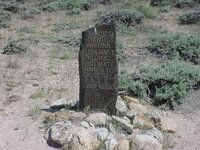
I think this next marker is located right at the Continental Divide, the road/trail just starts to dip off to the west, to Pacific Springs.

Just in case the marker isn't readable in the photo, it says, Narcissa Whitman and Eliza Spalding were the first white women to cross that pass on July 4, i836. They also had the first wagons to cross the pass. The wagons didn't make it all the way to Oregon. I think they had to leave them about where Boise, Idaho is now. The Whitman's actually established a mission near where Walla Walla, WA is now, and the Spalding's established a mission among the Nez Perce in Idaho. Whitman's mission was actually on the Oregon trail, and became an important location for the immigrants, much like Fort Bridger also was an important stop to rest, recoup and re-supply. Those wagons weren't the first wheels across though, a fur trapping brigade had a cannon with them some years earlier, and those were the first wheels across the divide.
And the last picture is the Oregon trail looking east from the Whitman marker.

When I posted this, the next two pictures were also included, and I didn't even know they were there, and don't know how to delete them. The next picture is South Pass, and the arrow shows about where I think the Whitman marker is looking east. The dark spot in the green area below the arrow is probably the buildings/ghost town. The last picture is a repeat, don't know what I did that put it there. Oh well, such is life.
South Pass (Wyoming) - Wikipedia, the free encyclopedia
I was traveling east when I took this picture. South Pass is a broad, open plain, with the Wind River Range to the left, and Pacific Butte is on the right, then out of the picture there's Oregon Buttes and the Rocky Mountains continue south.
Just pass the divide, on the west slope, the trail split. One branch continued on to the Green River, then to Fort Bridger and split again, either for the California gold fields, or on to Oregon. The next photo is the cut off trail to Fort Hall, Idaho, then on to Oregon.
I didn't have time to explore that trail, so I left the paved road, and headed over toward the divide. I continued on a dirt road that followed the trail for a couple of miles I guess, and arrived at a cluster of buildings at Pacific Springs, which I suppose feeds Pacific Creek. Off to the left out of the picture is a beautiful meadow full of lush green feed. I expect that area was fed down to dirt when the immigration was going on. I don't know if this qualifies as a ghost town, but I'm sure it was a stage stop and probably saw a lot of activity freighting before the railroad came through.
From here is was a short distance to the divide.
I think this next marker is located right at the Continental Divide, the road/trail just starts to dip off to the west, to Pacific Springs.
Just in case the marker isn't readable in the photo, it says, Narcissa Whitman and Eliza Spalding were the first white women to cross that pass on July 4, i836. They also had the first wagons to cross the pass. The wagons didn't make it all the way to Oregon. I think they had to leave them about where Boise, Idaho is now. The Whitman's actually established a mission near where Walla Walla, WA is now, and the Spalding's established a mission among the Nez Perce in Idaho. Whitman's mission was actually on the Oregon trail, and became an important location for the immigrants, much like Fort Bridger also was an important stop to rest, recoup and re-supply. Those wagons weren't the first wheels across though, a fur trapping brigade had a cannon with them some years earlier, and those were the first wheels across the divide.
And the last picture is the Oregon trail looking east from the Whitman marker.
When I posted this, the next two pictures were also included, and I didn't even know they were there, and don't know how to delete them. The next picture is South Pass, and the arrow shows about where I think the Whitman marker is looking east. The dark spot in the green area below the arrow is probably the buildings/ghost town. The last picture is a repeat, don't know what I did that put it there. Oh well, such is life.
Amazon Forum Fav 👍


Attachments
Last edited: