Spanish Clock Map.........

Only the shadows know?

  • Walking in the past?

    Votes: 0 0.0%

  • Total voters
    4

Rawhide

Silver Member
Nov 17, 2010
3,590
2,185
SouthWestern USA
Detector(s) used
Nox 800, Etrac, F75, AT Pro. Last two for sale.
Primary Interest:
All Treasure Hunting
I find the clock map entertaining. The information sounds good. If you havent walked a few sites, this would be a very confusing discussion. There is a few numbers that keep popping up and you will quickly catch on to those if you take 30 seconds and use a compass to the corner markers. The key here is how a site could be layed out within a deposit of ore. I was always asking myself how do they know where to put the monuments in reference to the ore? This may have answered that question. I need some time to think about it.

I believe a compass rose is the North Indicator on any map. I have found the four main directions used and markers off set at approx 30' degrees.

The hoyo or what some is calling a window rock very well may direct you to another area. While a marker may give you a general area of a cache, I have yet to find even a empty hole at a marker. But many a hoyo has lead to a empty hole.

I have only one question for the map maker here. What would be the distance between markers you would be working with? 1/4 mile, 1/2 mile, 20 miles?

As for turtles, I have found only one way to treat a turtle. Since there can be many meanings there is no one answer here. As OD said, a turtle will look right at a permanent water hole. There may be more to there than meets the eye at first glance. Examine your turtle very closely for clues. I dont share much here as I am usually out looking. I do enjoy the post and what others have found.

I am about tired of looking at owls and hearts. I need a expert on drill holes. I also would like the original poster of the clock map examine a site I have to see if he agrees I am using his map correctly.
 

Jan 16, 2011
5,010
5,037
By, By Have fun.
Detector(s) used
Time to move on. Good luck everyone .
Primary Interest:
All Treasure Hunting
twisted fork has some great stuff, look at his photos of markers at the openings,and what he says.i believe he is dead on. I know its said,if you can move it with your foot, its not a sign. but I don't by that. I have found some of the same stone shapes twisted fork has. and I believe they are very close to the opening, as he says. Minetres also gives out some good stuff that you never read about,that I belive is dead on. And dsty, he has got it figured out,i think so any ways. look at what he post about it don't matter where your at, looking in the right direction,n,s,e,w, at the tops of mountains,head there till you find the marker and your on your way,if you have his knowledge. look at his post about being along a river and what side to be on and where to head. hes got it figured out. drop him anywhere,and I bet with in minutes he can get you headed in the right direction. good stuff guys. thanks.
 

Rawhide

Silver Member
Nov 17, 2010
3,590
2,185
SouthWestern USA
Detector(s) used
Nox 800, Etrac, F75, AT Pro. Last two for sale.
Primary Interest:
All Treasure Hunting
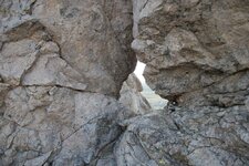
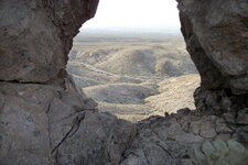
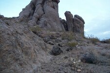
I really dont know where to post these photos, but this thread seemed more suited for them. I believe the clock map works here, so here is one view of what I believe to be a hoyo that marks a area of importance. I can tell you this hoyo is in the base of a monument, that can be seen for miles. It is on a north south line from a another monument. I believe the Compass Rose is a horse,heart,owl monument across the way and not in the pictures. When I took this pictures, I did not know how to line the shot up, so it is not showing anything of importance. Well maybe not much anyway. Anyway enjoy the photos.

hoyofront.jpg hoyoback.jpg
 

Shortstack

Silver Member
Jan 22, 2007
4,305
416
Detector(s) used
Tesoro Bandido II and DeLeon. also a Detector Pro Headhunter Diver, and a Garrett BFO called The Hunter & a Garrett Ace 250.
Primary Interest:
All Treasure Hunting
Casca:
I wore out my crayons on these last 2 photos. :)
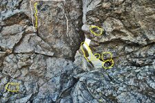
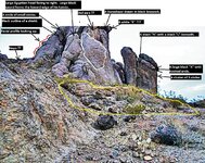
In the first pic, that area in the upper left with the white outline can be one of two things. (or both, you decide). I t can be the face of an animal with the right side destroyed by some one with a hammer and chizel; OR it could be the facial profile of a human facing to the left and indicated by the yellow line. That gap in in the white linework because there is a shape there that looks like a small face with some black radial lines shooting out.......or that part could be natural. I mean, teeny-tiny faces could easily be natural because such small work wouldn't be easily seen by confederates coming along behind the "marking" group. That lower left circle is around a group that looks like "8 7 X " or "8 9 X " or "8 g X ". Now for some better stuff.....that lower right circle is a "peep sight" and just above it, in the next circle is, what looks like an "A" on it's side, but I think it is actuall a "V" laying on it's side with a short vertical dash line. The middle circle encloses a small notch (mouth ?) that might be another sighting point. Then, there's George Washington's nose in profile in the left circle. That last circle just above is around some black marks that look like "M L V" .

hoyofront--Casca.jpg

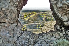
In the second photo, there's a carved notch in that lower left circle.......maybe a sighting line for a back bearing?? Then, in the distance, that lower center circle is around what looks like a white (lightened) "X". Further in the distance, in the left circle is a figure that looks like a large shape of a horsehead or a human form. Then, that area in the rectangle sure looks like it was once dug out. That area just doesn't LOOK like water erosion did all of that. Why that area and the other one just to the right did not erode nearly as badly. The circle at the head of that second cut, is around what looks like some black numbers or letters. Then that last circle on the right is around what looks like some large WHITEISH (lightened ?) numbers almost as big as you vehicle that's sitting in the wash (road?)
Oh, and I ALMOST marked your glove as Spanish finger carvings. LMAO

hoyoback--Casca.jpg
 

Rawhide

Silver Member
Nov 17, 2010
3,590
2,185
SouthWestern USA
Detector(s) used
Nox 800, Etrac, F75, AT Pro. Last two for sale.
Primary Interest:
All Treasure Hunting
Hi SS. you marked out some ruins and part of a pit mine maybe. If I have aligned up the sigh you would see much much more. The front of this monument has some markings I have never seen anywhere. If you pan out the back side of this marker looks like a man with his back to the marker hiding. Its just a fun rock, if you want to see more I have a site called the owl site posted here. Rangler my best of buddys mentioned hoyos with gun sights. So this one is for him. I did not agree with the rest of his post, but he is aware of that. This hoyo is actually a half moon, but I do not believe it was silver they mined here. Im pretty sure they found gold here. This was a rather large area, and I could see many partys starting here before their trek north or south. I suspect there will be many small personal caches to be found here, and I found the tax mans mark so may be a vault or two. Behind this marker is a small town, down below looks like a place they kept animals. I have only explored a few peaks here, and was not disappointed in what I found. This sight feels different than my last sight of monuments. I cant put my finger on it. The last sight you could clearly tell the three main trails apart. This sight appears to only have two trails. Both were used by a large number of people, very confusing indeed.
 

Rawhide

Silver Member
Nov 17, 2010
3,590
2,185
SouthWestern USA
Detector(s) used
Nox 800, Etrac, F75, AT Pro. Last two for sale.
Primary Interest:
All Treasure Hunting
Gentlemen,
I have stated many times that a turtle is no indicator of gold or silver.
Sometimes treasure is not what you percieve it to be. (I have a turtle pointing at a permanent water source)

A turtle missing the head is an old wives tale and totally untrue. it has been passed down (by treasurehunters) for years, only to create security for a site. Early t-hunters would break the head off to make other T-hunters believe the treasure is gone and thus give up. I have proved it over and over. (earlier pictures show the head in place)
Lets not perpetrate old falshoods if we know better.

This turtle is not looking at water.
turtle.jpg SS, there is heart buried here with a map on it. Please get those crayons out. The turtle is looking at a large griffin. I have been in the whole. There is a lizard carved rock in the floor looking out, and a monk or friar in 3d looking down in the wall. There was the worst smell I have ever smelled here, and I didnt spend too much time here.

This is the top part of the clock map in the OP. If it generates interest Ill show the bottom part. But I dont have pictures of the mine yet. The bulkhead is still intact.
 

Last edited:

Shortstack

Silver Member
Jan 22, 2007
4,305
416
Detector(s) used
Tesoro Bandido II and DeLeon. also a Detector Pro Headhunter Diver, and a Garrett BFO called The Hunter & a Garrett Ace 250.
Primary Interest:
All Treasure Hunting
OK, Casca:
You asked for it......and politely, too. LOL

I adjusted the lighting and contrast and, MAN, there are a LOT of letters, numbers, symbols, etc on this little bugger, so I used some tags. I didn't tag EVERYTHING, though. That large area, in the middle fore front outlined in yellow looks like a pile of riprap thrown into a hole to fill it up. And the area on the vertical front of the monument, outlined in white looks like the face of an Inca / Aztec / Mayan warrior or king complete with his tall top-knotted hat/hairpiece.

I didn't try to tag or circle everything "seaable" in the photo. There is a black stick figure shape just to the lower left of the white lined area. I looks like a stickman with a chest shield and arm shield and there's a "Y" and another letter down between his legs. (no comment)

Take note of that long, black sword that forms the edge of the hairdo on that Egyptian profile.

That tall, vertical recessed area just to the left of the Egyptian head is FILLED with black drawings the entire height.......ground to top.

The entire side of the turtle's neck and shell rock is filled with symbols.

There are loads of small circles all over the turtle and shell,as well as the rest of the faces of the monument.

turtle--Casca.jpg
 

dsty

Bronze Member
Dec 2, 2007
1,300
736
Randal County
Hello Casca, It is my belief that heigth determines distance, perhaps a turtle may indicate what you will need, provisions, water ,slow going. My thoughts are 33" = pace, 69 paces = a cordel= 189.5 feet, 7 cordel's = 1326 feet or 1/4 mile - 6 feet. I use 1320 feet, X 10, I use 2.5 miles as a league I didn't bring my caculator with me but I believe 13200 feet or 70 cordel. There may be a 44 inch high / horzional at each 1/4 mile. THATS between corner markers. I don't have any info about Mines and such but I believe there should'nt be that much difference, It is my belief that once you get things figured out that it will be a walk in the park to go from one to the other and quit all the walking around looking at rocks and scratiching your head or in my case rubbing your hand around top. I BELIEVE that this entire country was surveyed and layed out in league square. I also believe that land that had the prospects of becoming settled and had water / food sources, also had a cache in the NW corner, and it was #'ed by placing two / 3 letters of the alphabet together indicating the section / township / range on a map but its been destroyed. Got 6 minutes left see ya later.
 

Rawhide

Silver Member
Nov 17, 2010
3,590
2,185
SouthWestern USA
Detector(s) used
Nox 800, Etrac, F75, AT Pro. Last two for sale.
Primary Interest:
All Treasure Hunting
dsty is as right as rain as elevation is a key for me in the monuments. The corner stones stand out and the areas are usually marked up well. I dont have anyway of measuring but would say your measurements are as close as anything. This turtle is different. Here is why, it is of a smooth stone where all the surrounding stone is rough. The turtle also has a large heart on it s back. Now I wont go into markings on the turtle as I would get told I was wrong about those too. But there is some interesting workings within a stones throw of the area. SS is correct about there being a lot of markers here. The unique thing about this rock workings is it shows the life of Jesus. From birth to him rising again. This rock is just a small piece of it.

I have notice a layer of greenish rock just under a iron layer. Not much quartz to be found here, but a sample taken home appeared to have some gold in it. I have waht appears to be a old pit mine, and there is some older diggings in two more locations. The mines themselves are backfilled and perfectly hidden. I can located backfill easily with my detector. There appears to be certain things you will find when close to a Spanish mine area.

Now to study SS markings for a bit. The Spanish Clock Map could work here. But the clock map does not take into account what is else is there.
 

Rawhide

Silver Member
Nov 17, 2010
3,590
2,185
SouthWestern USA
Detector(s) used
Nox 800, Etrac, F75, AT Pro. Last two for sale.
Primary Interest:
All Treasure Hunting
Hello Casca, It is my belief that heigth determines distance, perhaps a turtle may indicate what you will need, provisions, water ,slow going. My thoughts are 33" = pace, 69 paces = a cordel= 189.5 feet, 7 cordel's = 1326 feet or 1/4 mile - 6 feet. I use 1320 feet, X 10, I use 2.5 miles as a league I didn't bring my caculator with me but I believe 13200 feet or 70 cordel. There may be a 44 inch high / horzional at each 1/4 mile. THATS between corner markers. I don't have any info about Mines and such but I believe there should'nt be that much difference, It is my belief that once you get things figured out that it will be a walk in the park to go from one to the other and quit all the walking around looking at rocks and scratiching your head or in my case rubbing your hand around top. I BELIEVE that this entire country was surveyed and layed out in league square. I also believe that land that had the prospects of becoming settled and had water / food sources, also had a cache in the NW corner, and it was #'ed by placing two / 3 letters of the alphabet together indicating the section / township / range on a map but its been destroyed. Got 6 minutes left see ya later.

There really is no way to walk this out due to terrain. But they may have solved that problem with a backstaff or some astrological measurement. Seems to be stuff going on every 2.5 miles or so. Due to the way the ore lies, the clock map would work. Take a line and draw a "S" on top of it. I have seen different variations of this clock map. As there is more going on than turtles and water. One day I hope to get a good gps and laser range finder and see how pi measures into all this. I like to study ancient building techniques like the Pyramids as I think the folks who set this up has been trained since the days of King Solomon.
 

Rawhide

Silver Member
Nov 17, 2010
3,590
2,185
SouthWestern USA
Detector(s) used
Nox 800, Etrac, F75, AT Pro. Last two for sale.
Primary Interest:
All Treasure Hunting
Dsty, you feel the nw corner is key to the cache site for these league square's? I would want to know how to start a search for such caches. Would it be deep? Do you know the construction of the caches? I might as well asked what a turtle sign means lol. There seems to be one or two signs that I dont ignore. Do you think it is possible they give you three markers and your to find the fourth? Do you think it would be prudent for them to put a vault say 1/4 mile from a corner marker? This is getting fun for me, I hope Im not confusing.
 

Shortstack

Silver Member
Jan 22, 2007
4,305
416
Detector(s) used
Tesoro Bandido II and DeLeon. also a Detector Pro Headhunter Diver, and a Garrett BFO called The Hunter & a Garrett Ace 250.
Primary Interest:
All Treasure Hunting
Casca:
Concerning your finds on how the ore veins are running through your project area..........you should read the section of the book De Re Metallica that begins on page 43 that concerns veins and how they are tracked. There is a drawing of a very interesting compass rose, too. If you don't have a hard copy of your own, there are ecopies on the web that you can read for free.

EDIT: There's something that came to mind that I'd like to get your opinion about. In post #64, above, those small numbers and letter in the lower left circle is a little bit strange and I'm wondering if those really small numbers, etc, could be the "worker code" of the person who either carved the hoyo OR the coded ID number for the guy who destroyed (or tried to destroy)_ that possible owl outline that I marked with the white outline. If that does not make sense, then I'm flummuxed about it...........LOL, I couldn't resist using that word. :laughing7:
 

Last edited:

Rawhide

Silver Member
Nov 17, 2010
3,590
2,185
SouthWestern USA
Detector(s) used
Nox 800, Etrac, F75, AT Pro. Last two for sale.
Primary Interest:
All Treasure Hunting
The area has seen a lot of folks, I even had some gang sign painted on a rock about a 1/4 mile away. As I got closer I could see lambs and a large duck. The angle here is not very good. This is a bad picture or the marker. I was more interested in the hole up above. I find the holes have neat stuff in them that doesnt get destroyed. I have more pictures if you like?
 

dsty

Bronze Member
Dec 2, 2007
1,300
736
Randal County
Well I looked at my reference info and 1.833 = 1 acre and it also = 2 cordel's or 2 X 189.5 feet. I really do enjoy this when things come together. I have seen a large turtle with a lot of 1/2 marble size dots that could very well be a Royal Trail and lots of other information. The marble size holes most likley will be a trail of sorts, even smaller sometimes BB size will indicate a short near-by trail, it showed 7 markers and was less than 3 inches long with the shape of of a old time dipper with a handle, really neat. Most of these type maps will be at the start of the trail and will be on the south end. Perhaps there may be something carve on top of any large creature, Those type maps ( small ) may be concealed with a small flat rock sitting on top of a larger boulder, to conceal and to protect it from the elemennts
 

Last edited:

dsty

Bronze Member
Dec 2, 2007
1,300
736
Randal County
Hello Casca, yes I do believe that the NW corner marker has the most interest to reveal, There will be a windrose complete with all the distances and degrees, information as to if you are working with a triangle / square / or rectangle. It is my belief that adding the total measurements will give you the distance between the windrose,s, sides of the found info = 189.5 + 189.5 + 95 = distance for example, from the windrose that has ALL of the info to the other part of the windrose with parts missing, in order to work the 2nd you must have ALL the info off the 1st, the complete part seems to be on the East side of the yard, the one that just has a part of the info will ( in my travels ) be on the west side of the yard, the reason for the different triangle, square, rectangle is because they needed / wanted the distance to get to a area that was satisfactory for their purpose. And I think it was just to mess with your mind in some cases If more info is needed PM me if necessary
 

dsty

Bronze Member
Dec 2, 2007
1,300
736
Randal County
Just bringing this back to the top for its information, seems they used this information for more than just Mines / Cache, I was not there when they did it so it will be a challenge to get it figured out, They Used 1/2 of a windrose to show the distances with all information needed to find the cache site at another location, except the would go a certain distance and for a triangle they would show 2 corners and using the map to locate the other corner, same with a square and a rectangle.
 

dsty

Bronze Member
Dec 2, 2007
1,300
736
Randal County
I do believe that there will not be a mark / carving at a any cache / mine or anything else that has any value to it, It seems that they used vaults to conceal even tools simply because old Spanish tools have been found inside shallow caves.
 

Top Member Reactions

Users who are viewing this thread

Top