✅ SOLVED Strange massive formation in the marsh

tattvamu

Tenderfoot
Dec 9, 2014
7
1
Charleston SC
Primary Interest:
Beach & Shallow Water Hunting
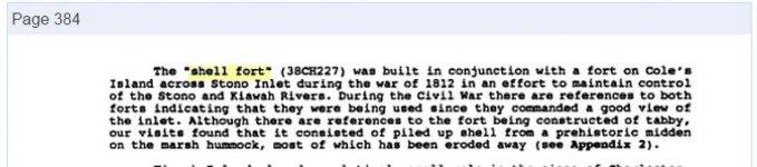
While flying over Folly Beach, years ago I spotted what appeared to be a massive stone circle in the middle of the marsh. I have made multiple attempts to take my small boat out there at high tide, to no avail. Is anyone on here experienced in maritime navigation so that I can plot the most logistic way to reach it to investigate? If anyone cares to see it, you can find it on google maps with the satellite view. I have researched extensively, and have found no evidence that a lighthouse ever existed here. In fact, if you compare the stone circle with the Morris Island lighthouse a couple miles away, the circle absolutely dwarfs the lighthouse. I also did not find any records at the library of any fortifications in that area. There is a nearby island that I could rent if anyone wants to go with me, because I fear going out in a sea kayak alone in the marsh. I'm not even sure the kayak can get me there, but since I don't have a hovercraft, I'm out of options.
 

Ant

Silver Member
Aug 6, 2006
3,389
554
Cali
Detector(s) used
Glold Bug 2 MineLab SE
Fish Trap, but you say massive, how many feet wide would you estimate it being?
 

Upvote 0

Charlie P. (NY)

Gold Member
Feb 3, 2006
13,006
17,114
South Central Upstate NY in the foothills of the h
Detector(s) used
Minelab Musketeer Advantage Pro w/8" & 10" DD coils/Fisher F75se(Upgraded to LTD2) w/11" DD, 6.5" concentric & 9.5" NEL Sharpshooter DD coils/Sunray FX-1 Probe & F-Point/Black Widows/Rattler headphone
Primary Interest:
Metal Detecting
I have Google Maps on Morris Light, SC. What compass heading from the Light to get to the mystery circle? I didn't spot anything just poking around.
 

Upvote 0

BosnMate

Gold Member
Sep 10, 2010
6,916
8,441
Detector(s) used
Whites MXT, Whites DFX, Whites 6000 Di Pro
Primary Interest:
Other
I went to google earth, and found the Morris Island Lighthouse, but couldn't find a stone circle. From the lighthouse, where do I look. Found a square foundation on the beach, looked to be pretty large.
 

Upvote 0
OP
OP
T

tattvamu

Tenderfoot
Dec 9, 2014
7
1
Charleston SC
Primary Interest:
Beach & Shallow Water Hunting
it's off the coast of cole island, it appears to be at least 100 feet in diameter. the square thing on the beach is from the old boardwalk, it's covered in graffiti. beach erosion washed it up. 32.640035, -79.988733
 

Upvote 0

Bramblefind

Silver Member
Nov 26, 2009
2,922
3,843
New York
Detector(s) used
T2/F75 SE
Here are some photos for the thread :)
 

Attachments

  • stones.jpg
    stones.jpg
    133.8 KB · Views: 268
  • stones2.jpg
    stones2.jpg
    78.9 KB · Views: 222
Upvote 0

Charlie P. (NY)

Gold Member
Feb 3, 2006
13,006
17,114
South Central Upstate NY in the foothills of the h
Detector(s) used
Minelab Musketeer Advantage Pro w/8" & 10" DD coils/Fisher F75se(Upgraded to LTD2) w/11" DD, 6.5" concentric & 9.5" NEL Sharpshooter DD coils/Sunray FX-1 Probe & F-Point/Black Widows/Rattler headphone
Primary Interest:
Metal Detecting
Now that I see it I agree: that is pretty weird. Looks like cleared patches 12 to 15 ft square with structures on the west rim.

I'd take the feeder coming in from Cole Creek to the east and then slog the last bit by foot.

Also - looks like a derelict sailboat at 32.638116, -80.001901
 

Upvote 0

57chevy

Full Member
Oct 4, 2014
105
87
The West
Detector(s) used
Whites 6000 D Looking to find enough to replace it.
Replaced it with a Garrett 350
Primary Interest:
All Treasure Hunting
This sounds like a job for America Unearthed.
 

Upvote 0

junkless

Full Member
Nov 4, 2012
115
40
Primary Interest:
All Treasure Hunting
Yep, something there for sure. It was visible back in 1957 which you can see at Historicaerials.com. The footprint of the individual blocks, according to my calcs, look about 8'x10'.

****Instant edit- FOUND IT!!!****

according to this map it's labeled as "old shell fort"
Map of Morris, Folly, Coles and James Island etc., and Charleston Harbor S.C. shewing [sic] Union and Rebel forts and batteries, 1864. | Library of Congress

Pretty cool!

*edit 2*
http://www.jstor.org/stable/27569450?seq=4
according to this site..."On Coles Island on the Southern edge of James Island the old tabby fort built in 1812 which fifty years ago was far from the water line is now daily threatened by the tide and fast disappearing" Not sure this is related but finding good info about forts all over that area.
 

Last edited:
Upvote 0

Bramblefind

Silver Member
Nov 26, 2009
2,922
3,843
New York
Detector(s) used
T2/F75 SE
I just found this reference ---

Full text of "The history of the 127th New York Volunteers, "Monitors," in the war for the preservation of the union -- September 8th, 1862, June 30th, 1865"

On September 1st Company E made a reconnoissance to
White House and up Secessionville Creek. On September 5th
Lieutenant Coggeshall resigned and returned North. The four
"Left"' companies, viz: D, A, H and K left camp at 7 a. m. and
were transferred to Coles Island, where they relieved the pickets
of the 74th Pennsylvania Volunteers, and on Sunday, , Septem-
ber 6th, the other companies of the regiment joined them.


74 REGIMENTAL HISTORY

Our new camp was made in a grove of live oak trees near
the landing and in the vicinity of the old shellfort supposed to
have been erected by the Spanish. The so-called "Fort"
was a circular wall, originally some ten or twelve feet high and
five to six feet thick, made of a concrete of oyster shells as solid
as masonry. It was useless for our purposes, however, except as a
breastwork, which the situation here did not require. We found
better water here than on Folly Island, although it was far from
appetizing. Owing to the nature of the ground, drilling was prac-
tically limited to squads, and the chief duty was on the picket line.
Adjoining Coles Island and connected with it by bridges and
dykes was Horse Shoe Island, and on the banks of the stream sep-
arating this from James Island our picket line was established.
The Confederate pickets were on the opposite bank, which at
some places were not more than two or three hundred feet dis-
tant, and at low tide the intervening space could be crossed with-
out difficulty, as the mud was but a few inches deep.
 

Upvote 0

junkless

Full Member
Nov 4, 2012
115
40
Primary Interest:
All Treasure Hunting
Thats awesome! So cool to think about the possibilities of that area. Legal to metal detect? Wisconsin is frozen solid, things like this make spring seem so far away.
 

Upvote 0

Bramblefind

Silver Member
Nov 26, 2009
2,922
3,843
New York
Detector(s) used
T2/F75 SE
Yep, something there for sure. It was visible back in 1957 which you can see at Historicaerials.com. The footprint of the individual blocks, according to my calcs, look about 8'x10'.

****Instant edit- FOUND IT!!!****

according to this map it's labeled as "old shell fort"
Map of Morris, Folly, Coles and James Island etc., and Charleston Harbor S.C. shewing [sic] Union and Rebel forts and batteries, 1864. | Library of Congress

Pretty cool!

*edit 2*
JSTOR: An Error Occurred Setting Your User Cookie
according to this site..."On Coles Island on the Southern edge of James Island the old tabby fort built in 1812 which fifty years ago was far from the water line is now daily threatened by the tide and fast disappearing" Not sure this is related but finding good info about forts all over that area.


Great research! :thumbsup: I think you are correct with the 1812 reference -- here is another:

The History and archaeology of Kiawah island, Charleston County, South Carolina - Michael Trinkley, Natalie Adams - Google Books
 

Attachments

  • shellfort.jpg
    shellfort.jpg
    28.7 KB · Views: 122
Upvote 0

maxpower

Sr. Member
Apr 29, 2005
303
141
Massachusetts
Primary Interest:
All Treasure Hunting
Fort Palmetto (1)
usaflag.gif
csaflag.gif

(1810's, 1861), Coles Island
Once located on Coles Island, but due to erosion it is now in a marshy area and is accessible only by boat. High tides wash over the ruins. This fort was first built during the War of 1812. The Confederates briefly used it after the fall of Fort Sumter, known as Coles Island Fort, but abandoned it. The island was used by the Union during the assault on James Island in 1863.
 

Upvote 0
OP
OP
T

tattvamu

Tenderfoot
Dec 9, 2014
7
1
Charleston SC
Primary Interest:
Beach & Shallow Water Hunting
Thank you all so much! My dad(trk5capt) was a long time member here, and I knew there was a wealth of knowledge here. I don't know how nothing turned up at the county library, but i'm glad to have some answers. I believe it is legal to metal detect there, but to be sure I'm going to ask the couple who owns the island. They live here on James Island. The sands shift a lot in Cole creek, and you frequently bottom out. It seems to be unspoiled, unlike most of the other fortifications around here. I plan on going out there as soon as I can, and I will post pictures of the formation and any artifacts I find. If anyone lives in the area and wants to go with me to have a better look, let me know.
 

Upvote 0
OP
OP
T

tattvamu

Tenderfoot
Dec 9, 2014
7
1
Charleston SC
Primary Interest:
Beach & Shallow Water Hunting
found this on scbattletrust.com-
Much of Coles Island was destroyed in the hurricane of 1911, leaving Fort Palmetto standing in the marsh just south of the remnants of the island. The Fort Palmetto site is preserved by the South Carolina Battleground Preservation Trust through a permit issued in 1992 by the South Carolina Coastal Council. The site is accessible only by boat at high tide. The remnants of the circular tabby wall are only visible at low tide.
 

Upvote 0

Top Member Reactions

Users who are viewing this thread

Latest Discussions

Top