T
treasurejack
Guest
Can anyone tell me the known origin & history of these mines?
Real de Tayopa said:HI:I am curious also.
Don Jose de La Mancha
")
Springfield said:Tusayan was the indiginous name used by the Hopi to describe their domain when the Europeans arrived in the American Southwest in 1540. Later, the invaders called them Moqui, a word from the Navajo or Zunis meaning 'dead'.
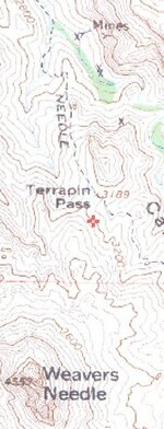
The interesting aspect of the map is "Terrapin Pass". Why is it called that?
treasurejack said:Can anyone tell me the known origin & history of these mines?

Oroblanco said:WELCOME TO TREASURENET AlaskaBill!Thank you for posting!
Oroblanco