tayopa, legend or reality ...?

bandit

Greenie
Nov 2, 2005
17
0
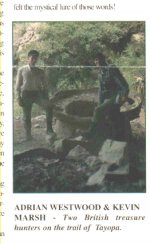
My friends Don Jose and Cactusjumper,

Thanks for the good information on the Tayopa site, including the comments on the flora. Everything seems to line up.

I agree with CJ that the guerigo tree clue given by Dobie is probably long gone if it was ever valid anyway. Moreover, sounds as if there's nothing special about guerigos.

If possible, I'd like to pick another thread of previous discussion-Nino Cochise. As I remember, Cactusjumper doesn't place much credence in anything that Nino wrote in The First Hundred Years. I tend to agree, but I wonder if there's anything in the book that's true or valid. In other words, did Nino just cobble together a lot of stories he had heard and read about, or did he just exaggerate some of his own experiences. Have there been any other eyewitnesses that can corroborate his participation and actions in the accounts he has written?

I bring Nino up again, in part because he claimed to have seen Tayopa and in the hardback version of Hundred Years he provides a very general map of its location in the frontispiece. Clearly it's not Don Jose's Tayopa, but rather seems to be either Tayopa#1 or Tayopa#2 and closer to the Guaynopa country.

Also, What about the credibility of A. Kinney Griffith? Was he simply taken in by Nino, or was he part of the something more deceptive?
 

cactusjumper

Gold Member
Dec 10, 2005
7,754
5,388
Arizona
Bandit,

Two points about the guerigo tree: I have heard they are not a long lived tree, and they need lots of water. Not just water.......but lots of it.

I believe that A. Kinney Griffith would be considered a writer of historical fiction by many historians.

Nino is not recognized by the Apache. Many of the problems with the book have to do with Apache customs. In addition, the type of lifestyle he claims they lived in Mexico, does not conform in any way with what we know about the "Wild Apache". To see how they lived down there, you might want to read Goodwin.

While I own a signed first edition, it's not a book I would ever use for a source on the Apache. As I understand it, there is not a single piece of evidence or testimony to corroborate his story.......while he claims he was living in Mexico.

Take care,

Joe
 

bandit

Greenie
Nov 2, 2005
17
0
Hi Joe,

Thanks for your prompt reply to my post. I brought up Nino in part due to his alleged connection to Tayopa. Most of his Tayopa references are sketchy, but even here there are errors. For example, Nino/Griffith seem to think that Tayopa was a gold rather than a silver mine. In Chapter 7, in a footnote Nino recounts a story where Apaches ambush a mule train laden with gold from Tayopa and are in turn ambushed by scalphunters led by Mustang Gray. The problems with this scenario, of course, were (1) Tayopa didn't produce gold (2) the Tayopa mines were long since lost and out of production by the time the scalphunters arrived on the scene in the 19th century. Nino even claims that "[w]e spent several days exploring the fabulous Tayopa ruins."

Do you think that Griffith was the moving force behind First Hundred Years, or did he simply take down stories that Nino invented or embellished? Many of the details are certainly very specific.

Do you know Jack Purcell's The Lost Adams Diggings: Myth, Mystery, and Madness. Purcell seems to think that Nino is the genuine article, in part because Nino verifies and fleshes out some of the characters in the Adams story. In particular, Purcell says that the Americans in Mexico that befriended Nino are verified by Mexican land records, or at least the group of Americans involved in the Adams story (Tenney, Brewer, and Gray).

Best,

Bandit
 

Nov 8, 2004
14,582
11,942
Alamos,Sonora,Mexico
Primary Interest:
All Treasure Hunting
Evening Bandit::You are correct, Tayopa is silver, but Paramo IS gold. You are also correct, the last Jesuit workings in that zone were in 1767. Remains of the Jesuit cuartel/ headquarters/ church. would have been just a blob then, as now..

Don Jose de La Mancha

Present view--->
 

Attachments

  • Headquarters Cuartel 2.jpg
    Headquarters Cuartel 2.jpg
    18.8 KB · Views: 1,234

bandit

Greenie
Nov 2, 2005
17
0
My friend Don Jose,

The book is The First Hundred Years of Nino Cochise: the Untold Story of an Apache Indian Chief as told by Ciye Nino Cochise to A. Kinney Griffith, Abelard-Schuman, New York, 1971.

Among other things, Nino Cochise claimed to be the grandson of Cochise, the great Apache leader. He says that he was born in 1874 and that as a youth he was part of a group of Apaches that was with Geronimo when he fled to Mexico. Nino says that his group broke away from Geronimo before the surrender and that this small group made its way to a hidden stronghold in northern Sonora. He eventually became leader/chief of this last remnant and during the 1890's and early 1900's, they had many experiences fighting the Mexican army, outlaws. other Indians, as well as other adventures. Among other things, he says that he had access to a secret gold mine (conveniently called Sno-ta-hae, the same name used in Dobie's Apache Gold for the Lost Adams Diggings) that he used to support the group. He later appeared in some Hollywood films and he died in 1984 at age 110.

As I noted, he says that he visited Tayopa and was able to see it from his mountain stronghold in Northern Sonora. As Cactusjumper has indicated, many if not most authorities, (especially most Apaches) don't believe that Nino's story is authentic for a variety of reasons.

I'm certain that Cactusjumper can add much more about Nino and his dubious narrative.
 

bandit

Greenie
Nov 2, 2005
17
0
Good evening again, Don Jose,

Thanks for the photo of the Jesuit Cuartel. As with everything you post, it's very interesting. I was a little surprised you could get there by motor vehicle, and the landscape definitely looks less rugged than your earlier photo viewing mesa chico.

So the Jesuits returned to Tayopa after the 1646 massacre and resumed operations? Do you know about when this happened? And then they continued until the 1767 expulsion, right?

Thanks again. Always a great story, perfect for a movie.

Bandit
 

Nov 8, 2004
14,582
11,942
Alamos,Sonora,Mexico
Primary Interest:
All Treasure Hunting
Good morning bandit: As I mentioned the lumber mill was in line of sight of Tayopa. Because of the existence of two mills in the area, The road (??) was constructed fo following the sky line between the two states.

At one section the road is about 45 ft wide, on the right is Sonora, it drops at a 70 angle for 800+ft, on the left the same for Chihuahua. If you go off here, they never try to recover you, just strip you for any goodies
.
However the view if magnificent, you can see for almost 80 miles in Sonroa, and 15 in Chihuahua

In this picture you can see the lumber mill up at the top.

Don Jose de La Mancha
 

Attachments

  • Saw mill at the head of the Tayopa canyon.jpg
    Saw mill at the head of the Tayopa canyon.jpg
    62 KB · Views: 1,473

Oroblanco

Gold Member
Jan 21, 2005
7,838
9,830
DAKOTA TERRITORY
Detector(s) used
Tesoro Lobo Supertraq, (95%) Garrett Scorpion (5%)
HOLA Amigos,

Bandit wrote:
errors. For example, Nino/Griffith seem to think that Tayopa was a gold rather than a silver mine. In Chapter 7, in a footnote Nino recounts a story where Apaches ambush a mule train laden with gold from Tayopa and are in turn ambushed by scalphunters led by Mustang Gray. The problems with this scenario, of course, were (1) Tayopa didn't produce gold (2) the Tayopa mines were long since lost and out of production by the time the scalphunters arrived on the scene in the 19th century. Nino even claims that "[w]e spent several days exploring the fabulous Tayopa ruins."

and our mutual amigo Real de Tayopa replied:
Evening Bandit::You are correct, Tayopa is silver, but Paramo IS gold

This is one of the facts concerning Tayopa that has led to confusion on the part of treasure hunters and historians. A story gets circulated that tells of the infamous Tayopa silver mine but no mention of the other mines of the Real, another version tells of the gold mines of Tayopa without mention of the silver. Tayopa is what we call in the US a "mining district" a general grouping of several mines in a geographically small area *relatively* speaking. In Mexico during the heydey of Tayopa, such a group of mines relatively close together would be named a Real, ("Royal") and with the same meanings as we use when we say "Mining District" - including recording a mining claim ("denouncing" it in their legal terminology) and usually the miners would pay the Royal Fifth there and could obtain religious services of a padre stationed there - hence the presence of Jesuits in this case, Franciscans or Dominicans in other cases.

If memory serves there were no less than 18 (eighteen) different and separate precious metals mines associated with the Real de Tayopa, including the aforementioned Paramo placers. I think that at least a few of the hard-rock (lode) mines were and are primarily gold and not silver, and that even within at least one of the silver mines the ore vein contained quite high gold values at a certain depth.

Just an observation, please continue gentlemen...
Oroblanco

PS The fact that there are at least 18 minas in the Real de Tayopa gave me an idea that those infamous "Peralta Stones" so popular among TH-ers of the Superstitions, might in truth not relate to the
superstitions at all but perhaps are really a map related to Tayopa! Remember that inscription, "I
go eighteen places, hunt the heart..." *I may have this translation off a bit, working from memory* I have not attempted to relate the maps to the barranca country where Tayopa lies, might be an interesting experiment.
 

bandit

Greenie
Nov 2, 2005
17
0
Good afternoon amigos,

Thanks again to Don Jose for the photo of the sawmill at Tayopa canyon. The area is obviously more heavily wooded than I originally envisioned, which brings me to the Jesuit Cuartel. Based on Don Joses's photo and the surrounding countryside, I assume it was constructed of logs, right? If so, is there any evidence of a foundation or anything else that indicates the size and shape of the structure?

In reply to my friend, Oroblanco, I can only say "Point taken." Clearly, Tayopa was a Real de Minas of both silver and gold, but the tradition says that most of the extracted metal was silver rather than gold. My major point in the previous post was that Tayopa was already "lost" for about 75 years when the scalphunters were active.

There is a small matter in Oroblanco's post that merits additional comment/discussion (I think). My friend suggest that Tayopa was discovered by Spanish prospectors/miners (laity), and subsequently a priest or priests was assigned to the site to attend to the spiritual needs of the miners. On the other hand, ( and please correct me if I'm wrong), Don Jose suggests that Tayopa was, in fact, operated by the Jesuits, probably in secret. Or, is it a combination, i.e., the Jesuits over time simply took over the Tayopa operation?
 

gollum

Gold Member
Jan 2, 2006
6,729
7,598
Arizona Vagrant
Detector(s) used
Minelab SD2200D (Modded)/ Whites GMT 24k / Fisher FX-3 / Fisher Gold Bug II / Fisher Gemini / Schiebel MIMID / Falcon MD-20
Primary Interest:
All Treasure Hunting
One quick insertion here.

The Royal Fifth (Quinto), was not set in stone. The King's Share varied greatly with the types of minerals involved, richness of the ore, time frame, etc. It varied from 1/10th all the way to the King claiming everything.

Take, for instance, the exceedingly rich "Planchas de Plata". In 1736, a Yaqui Miner discovered huge slabs of raw silver just laying on the ground. A huge rush of miners swarmed to the area. When Philip V got word of this, he sent Capt. Juan Bautista de Anza to investigate. After receiving De Anza's Report, Philip declared the mine exceedingly rich, and therefore property of the crown. In 1741, the Viceroy declared the mine a "Curiosity" and not subject to the Mining Ordinances, ordering all the miners out.

Best-Mike
 

Nov 8, 2004
14,582
11,942
Alamos,Sonora,Mexico
Primary Interest:
All Treasure Hunting
Bandit, go up 7 posts to the picture of the Jesuit cuartel (headquarters) as you can see, it was of adobe construction. Yes, the foundation stones are probably still under that pile of rubble..

Don Jose de La Mancha
 

Nov 8, 2004
14,582
11,942
Alamos,Sonora,Mexico
Primary Interest:
All Treasure Hunting
Peerless, of course, but I do not know his exact path. In the rainy season, the primary north / south trail would go from Yecora, south on the Yokivo / Arisiachi trail on the ridge line, down to the Rio Mayo and onto Alamos. This would pass just above Paramo, (Grizzle bear spot)
don Jose de La Mancha
 

Peerless67

Hero Member
Jul 26, 2007
913
23
ENGLAND & CALIFORNIA
Detector(s) used
Eyes, ears and common sense
The reason I ask is that I just got done reading his book and also looking at the plates in the Scribners magazine article, after looking at your pictures and then reading his discription of his journey, one could almost imagine that you had traveled to that area together, of course I know not even you are that old :tongue3:

This part in paticular.

An ocean of mountains spread out before and below us. In the midst
of it, right in front of us, were imposing pine-clad mesas and two
weathered pinnacles of reddish conglomerate, while further on there
followed range after range, peak after peak; the most distant ones,
toward the south, seeming at least as far as eighty miles away. The
course of the rivers, as they flow deep down between the mountains,
was pointed out to us. The principal one is the Arros River, which
from the west embraces most of the mesas, and then, turning south,
receives its tributaries, the Tutuhuaca and the Mulatos, the latter
just behind a pinnacle. West of the Arros River stretches out the
immense Mesa de los Apaches, once a stronghold of these marauders,
reaching as far as the Rio Bonito. The plateau is also called "The
Devil's Spine Mesa," after a high and very narrow ridge, which rises
conspicuously from the mesa's western edge and runs in a northerly
and southerly direction, like the edge of a gigantic saw. To our
amazement, the guide here indicated to us where the camino real from
Nacori passes east over a gap in the "Devil's Spine" ridge, and then
over several sharp buttes that descend toward the mesa. An odd-looking
mesa lay between Rio Bonito and Rio Satachi. Farthest to the west
were the big hogbacks near Nacori, standing out ominously, like a
perpetuated flash of lightning. The sun was nearing the horizon; the
air was translucent, and the entire panorama steeped in a dusky blue.

Immediately below us, to our left, lay Guaynopa. The mountainside
looked so steep that it seemed impossible for us to descend from
where we were. But we already heard the voices of our muleteers
singing out to the animals 1,000 feet below, and that reminded us
that we also had better reach camp before darkness should overtake
us. We descended 2,500 feet, and, leaving the pines behind, found
ourselves in a warmer climate. It never snows here, according to our
guide. That the precipitation took the shape of rain we learned when
we were impeded by it for two days.

There were yet eighteen miles between us and the deserted
mines of Guaynopa. It was a laborious journey over the hills,
mostly ascent. Finally we came to a steep slope covered with oaks,
along which there was a continuous descent toward Guaynopa. While
zigzagging our way down, we caught sight of a large cave with houses
and some white cone-shaped structures staring at us across an arroyo
midway up the opposite side, which was at least two thousand feet
deep. Through my field glasses I could make out very distinctly a
group of houses of the usual pattern; and the large, white structures
could without difficulty be recognised as granaries, similar to those
observed in Cave Valley. It was my intention to go back and examine
this cave more closely, as soon as I had found a camping place; but
circumstances interfered. Several years later the cave was visited
by Mr. G. P. Ramsey, to whom I owe the following brief description.

The cave is situated about twenty-five miles in a straight line south
of the Mormon colony of Chuhuichupa. There are indications of a spring
in the cave, and there is another one in the arroyo itself. The
buildings are in a very bad condition, owing to the action of the
elements and animals; but fifty-three rooms could be counted. They were
located on a rocky terrace extending from the extreme right to the
rear centre of the cave. This extreme right extended slightly beyond
the overhanging cliff, and contained groups of two-storied houses. In
the central part of the cave were a number of small structures, built
of the same material and in a similar manner as those I described
as granaries in Cave Valley. They were still in excellent condition,
and, as will be seen at a glance, they are almost identical with the
granaries used to the present day in some southern States of Mexico.

We continued our descent, and, having dropped altogether some 2,000
feet, at last found ourselves alongside some lonely and unattractive
old adobe houses. They were built by the Spaniards and are reputed
to have once been the smelter of the now abandoned silver mine of
Guaynopa. Only the naked walls remain standing on a decline, which
was too steep to give us sufficient camping ground. So we went still a
little further, to the top of a hill near by, where we made a tolerably
good camp.

This then was the famous locality of Guaynopa, credited with hiding
such fabulous wealth. There was still another mine here of the same
repute, called Tayopa, and both of them are said to have been worked
once by the Jesuits, who before their expulsion from Mexico were
in possession of nearly all the mines in the country. According to
tradition, the Apaches killed everybody here, and the mines were
forgotten until recent times, when ancient church records and other
Spanish documents revealed their existence. Several expeditions have
been sent out, one, I believe, by the Government for the purpose of
locating them; but being situated in the roughest and most inaccessible
part of the Sierra Madre, they are still awaiting their rediscovery,
unless, contrary to my knowledge, they have been found in recent
years. There is no doubt that the country carries very rich silver
ore, and we ourselves found specimens of that kind; but the region
is so difficult of access that it probably would require too great
a capital to work the mines.

There was now a plain track leading along the hillside down toward
the Rio Aros, which is scarcely two miles off; but the country was so
wild and rugged that the greatest care had to be exercised with the
animals to prevent them from coming to grief. The path runs along the
upper part of a steep slope, which from a perpendicular weathered cliff
drops some 400 feet down into a gorge. As the declivity of the slope
is about forty-five degrees, and the track in some places only about
a foot wide, there is no saving it if an animal loses its foothold,
or if its pack slips. All went well, however, until we reached a point
where the track commenced to descend, when our villain of a guide tried
to drive some burros back on the track, instead of leading each one
carefully. The result was that one of the poor beasts tumbled down,
making immense bounds, a hundred feet at a time, and, of course,
was killed.

We had no difficulty in fording the Guaynopa Creek near its junction
with the Aros River, and selected a camping place on a terrace 200 feet
above it. The stream, which is the one that passes the cave-dwellings,
carries a good deal of limpid water, and there are abundant signs
that at times it runs very high. The elevation of the ford, which
is here about the same as that of Aros River, 3,400 feet, was the
lowest point we reached in our crossing of the Sierra Madre between
Chuhuichupa and Temosachic. It took us almost the entire day to move
the animals the one mile and a half to this camp. On the way we had
found some good quartz crystals in the baryte, about four inches high
and one inch in width.

The country before us looked more forbidding than ever, as if it
did not want us to penetrate any further into its mysteries, but our
guide seemed to be quite at home here.

Our march toward Rio Chico was about thirty miles of ups and downs,
ascending to a height of 7,600 feet and descending again some 3,000
feet. In the beginning it was almost impossible to make out the track;
where it did not lead over bare rocks, it was nearly obliterated
by overgrown grass. The first ascent was over a mile long in a
straight line; then, after a little while, came the most arduous
climbing I had until then ever attempted. Following the slope of the
mountain, the track rose higher and higher in long zigzags, without
any chance for the animals to rest, for at least three-quarters of
a mile. It was necessary to push them on, as otherwise the train
would unavoidably have upset, and one or the other have rolled down
the declivity. One large white mule, El Chino, after it had almost
climbed to the top, turned giddy at the "glory-crowned height" it
had reached, and, sinking on its hind legs, fell backward and rolled
heels over head down, with its two large canvas-covered boxes, like
a big wheel. As luck would have it, it bumped against a low-stemmed
old oak that cropped out of the hillside in an obtuse angle to it,
some ninety feet below. Making one more turn up the stem, the mule was
nicely caught between the forked branches, which broke the momentum,
loosened the cargo, and caused the animal to fall back into the high
grass. One box landed close by, the other, containing our library,
pursued its course downward 200 feet further, bursting open on the
way and scattering the wisdom of the ages to the winds, while the
mule escaped without a scratch.

The burros came into camp three hours after us, and the drivers
explained how they had succeeded in bringing them up the long slope
only by constantly punching them to prevent them from "falling asleep."

As we continued our journey toward Rio Chico the panorama of the
sierra changed continuously. We got a side view of the big Mesa de
los Apaches, and many weathered pinnacles of eroded conglomerate were
seen standing out like church spires in this desert of rock, varying
in colour from red to lead gray. Once we caught sight of a stretch of
the Rio Aros deep down in a narrow, desolate valley, some 3,000 feet
below us. The geological formation of the region is mostly volcanic;
then follows conglomerate, and on the high points porphyry appears.

We camped on the crest of the eastern side of the Rio Chico Canon,
in an ideal place with bracing air. A fine, sloping meadow afforded
quite an arcadian view with the animals peacefully grazing and resting;
but looking westward, the eye revelled in the grand panorama of the
sierra. The two sides of the Rio Chico Valley rise here evenly from
the bottom of the gorge so as to suggest the letter V. In many places
its brow is overhung by precipitous cliffs, and further down still
more steeply walled chasms yawn up from the river bed.
 

P

pippinwhitepaws

Guest
"we caught sight of a large cave with houses
and some white cone-shaped structures staring at us across an arroyo..."


are the cone shaped structures coke ovens or smelter?
 

Peerless67

Hero Member
Jul 26, 2007
913
23
ENGLAND & CALIFORNIA
Detector(s) used
Eyes, ears and common sense
pippinwhitepaws said:
"we caught sight of a large cave with houses
and some white cone-shaped structures staring at us across an arroyo..."


are the cone shaped structures coke ovens or smelter?

In the book they are described as possible vessels for storing corn, I dont agree, but to be honest I have no idea.

Disclaimer, this post is not an attack on the educated and is by no means meant to show contempt.

:coffee2:
 

Nov 8, 2004
14,582
11,942
Alamos,Sonora,Mexico
Primary Interest:
All Treasure Hunting
Gentlemen, does this answer your question? From Adrian Westwoods stories and his book, recomended.

"JESUIT GOLD", A treasure hunters guide to Tayopa.\

Don Jose de La Mancha
 

Attachments

  • Cliff dwellings.jpg
    Cliff dwellings.jpg
    30.5 KB · Views: 1,304
  • .2.jpg
    .2.jpg
    24.3 KB · Views: 1,397
  • Adrian Westwod & Kevin Marsh.jpg
    Adrian Westwod & Kevin Marsh.jpg
    44.5 KB · Views: 1,228

Peerless67

Hero Member
Jul 26, 2007
913
23
ENGLAND & CALIFORNIA
Detector(s) used
Eyes, ears and common sense
RDT, have you ever seen the old church books and manuscripts from the Bacadehuachy-Bacadehuachi (?) church mentioned by Bandelier ? or do you believe he was just quoting something he heard.
The reason I ask is that there appears to be a coincidence between those books/manuscripts being mentioned and the earthquake of 1887 ?
Is it possible the jesuit link was confirmed in those records, and that maybe they came to light as a result of them being rescued from the ruins of the church?
 

Top Member Reactions

Users who are viewing this thread

Top