cw0909
Silver Member
- Dec 24, 2006
- 4,369
- 3,226
- Primary Interest:
- Other
Historically, Texans have turned to the Texas General Land Office for maps and other tools used to organize information about the natural resources this state has to offer. Besides historical maps, research, and data, the land office today uses Geographic Information Systems (GIS), global positioning systems (GPS), and computer-aided design (CAD) systems to compile, analyze, and distribute the most accurate information possible about the location of natural and human-made resources. These tools support the business functions of the General Land Office and serve as critical tools in the study and protection of our state's valued resources.
The Land Office website contains a collection of dynamic interactive mapping websites that give Texans access to the vast collection of spatial data available at the agency.
GIS Maps at the GLO
i was looking around for something and came across this tx map site
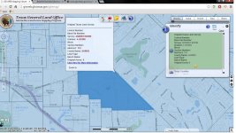
i went to this map.... NEW! GISWEB Viewer
snapped this img

clicked the more info in the info box and gave me these pgs so cool i didnt look
at the layer boxs so may be more stuff
Basefile Number Infomation
http://www.glo.texas.gov/ncu/SCANDO...aps/webfiles/landgrants/PDFs/2/3/3/233157.pdf
The Land Office website contains a collection of dynamic interactive mapping websites that give Texans access to the vast collection of spatial data available at the agency.
GIS Maps at the GLO
i was looking around for something and came across this tx map site
i went to this map.... NEW! GISWEB Viewer
snapped this img

clicked the more info in the info box and gave me these pgs so cool i didnt look
at the layer boxs so may be more stuff
Basefile Number Infomation
http://www.glo.texas.gov/ncu/SCANDO...aps/webfiles/landgrants/PDFs/2/3/3/233157.pdf


