mdog, this website provides some interesting correlations. The Kensington Runestone - Mystery Solved
I don't necessarily embrace all of what this websites presents - such as the Kensington Rune Stone code leading to Inspiration Peak - but the takeaway for me at this time is the nearly exact 1362-mile great circle distances measured from the top of IP to the geoglyphs at the US northeast, northwest and south land extents. Also, whereas the KRS was found in a nearly random spot in typical swell-and-swale farmland, Inspiration Peak is a high prominent knoll and an easy to find landmark for anyone looking for it. A surveyor might call it a benchmark or a control point. But for what purpose? In addition, I've discovered quite an intriguing geometrical link from IP to a strangely-named southwestern landmark that then aligns to a suspicious location in the Superstition Mountains in Arizona, located within a very prominent lat/long grid location. I have no plans to visit the area, but I do appreciate its beauty from a cartographic perspective.
I'm kind of a "show me" guy, and when I see stuff like this - physical evidence available for all to verify for themselves - I take notice. Especially when the evidence turns out to be a remarkable "coincidence". I don't know who chose this spot or created the geoglyphs, but they were capable hands. As you well know mdog, when you start discovering beautiful geometry that ties common themes together all across the country, it gets your attention. There's a method at work here on a grand scale.
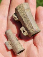
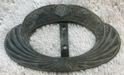
Incidentally, a number of medieval-era metal artifacts have been found through the years all over the upper Midwest, especially at the headwater region of the Red River. Below is a weapon found at Brandon, MN - twelve miles south of IP, halfway to KRS. Two additional battle axes are also shown. These and other artifacts are in the KRS Museum in Alexandria, MN.
View attachment 1217767
View attachment 1217774
View attachment 1217775
Here's a mystery that sdcfia's Inspiration Peak link helped me solve just a few minutes after I read it. I've been studying an alignment of mounds on top of a bluff of the Mississippi River. There are 20 mounds in the group but 8 of them are setup in a perfect line going from east to west with the largest of the mounds being on the east and the rest of them gradually decreasing in size with the 8th mound being the smallest. What little information I've been able to find about this group, mentioned an excavation that took place on 10 of them back in the 1870s. The 10 mounds were trenched down to two feet below ground level and nothing was found in any of them except for occasional traces of charcoal. This seemed unusual to me because there are hundreds of mounds in this area that are associated with burials of the Hopewell period and excavations have always produced some type of artifacts. The line of 8 mounds line up with the tip of an island in the river and I suspected that the mounds might have been acknowledging some type of solar event important to the Moundbuilders. On the fall equinox of a week ago, the sun came up just north of the island tip. According to a sun calculator that my grandson found for me, the sun will rise over the tip of this island on October 12th. This is Columbus day, the day in 1492 that Columbus landed in the Americas. Using google earth, I started a line at the largest mound and ran it to the point of the island and kept going toward the Atlantic Ocean. This line passed directly over the Washington Monument in D.C. So, this year anyway, on Columbus Day if you stand on the large mound and face the tip of the island, you'll be watching the sun come up over the Washington Monument. So this alignment of mounds was built much latter than the culture it was accredited to. Thanks for the link sdcfia. I don't believe there was any sinister intent, just an acknowledgment of an important event and location.


 It was like a soap opera that started before the first monopoly and it continues running now, but with thousands of spin-offs which makes the line to that door we spoke of so far away from you that you can't see it and never will unless.....a man or woman walks up to you someday while you are in line.....speaks to you and then takes you by the arm and walks you to the door.