The Pearl Ship

markmar

Silver Member
Oct 17, 2012
4,119
6,260
Primary Interest:
All Treasure Hunting
Hi again

I made another map which shows the deeper canals in the Delta Pass . One of these could be a possible route of the Pearl ship . The routes start from about 38 ft over the sea and ends to the highest limit in the deepest " throat " between Salton Sea and Gulf of California 46 ft .
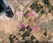
Routes.jpg

Good luck to those who are interested
 

Last edited:

markmar

Silver Member
Oct 17, 2012
4,119
6,260
Primary Interest:
All Treasure Hunting
And a last comment

If I wanted to go for the ship , I will choose the blue route , because is the closest to the sea drainage . If the Salton Sea was 46,5 ft over the sea level , there would be the only place to pass to the Gulf ( with a little boat ) . I added to the picture an orange line which represent the deep from 43 ft to 46 ft over the sea lebel .

Route.jpg

Have a nice day
 

Last edited:

auferret

Sr. Member
Sep 25, 2007
420
73
Tennessee
Detector(s) used
White's MXT
Sunray DX-1
Falcon MD20
Garrett Seahunter Mark II
Primary Interest:
All Treasure Hunting
I don't think you are taking into account all of the sand that was brought in by the Colorado river when it shifted in 1905 and created the Salton Sea. The elevations are very different now as opposed to when the pearl ship sailed in.
 

markmar

Silver Member
Oct 17, 2012
4,119
6,260
Primary Interest:
All Treasure Hunting
I don't think you are taking into account all of the sand that was brought in by the Colorado river when it shifted in 1905 and created the Salton Sea. The elevations are very different now as opposed to when the pearl ship sailed in.

Hi auferret

The water in any case follows the old canals to invade or to withdrawing . The 1905 flood made a good thing to the Pearl ship . If it was covered with many ft of sand , now are only few ft ( or less ) .
My advice is : the blue line DIRECTION is the KEY .
 

Last edited:

Dvotedwun

Greenie
Nov 1, 2014
12
11
Primary Interest:
All Treasure Hunting
Hi Folks, I have been Researching this area for lost ships for a long time since abt 1999,

Wow I should start off by saying, How happy i am to see there have been others who think and are interested in this kinda stuff,
Ive been the only one ive ever known, To wonder about these lost ship's in the middle of the Mojave desert,

My Friends and fam think im nuts, every time i start to talk about my general research over time,
and how Its really true, They turn there head or roll there eyes, haha I know better though, i can feel it in my Bones,
There is a ship or two, or three, out there, not to mention Who knows what other kinda undiscovered treasures out there.

My interests come from my Long residency in the Local desert there, Besides living in the Morongo Basin More then Half my Life,
I Eventually bought 2.5Acre's of land with an old Bare Bones Homestead Cabin, up in Lander's (just north of Yucca Valley) Its Near the "Integratron"
For anyone familyer with that area.
So Naturally After Googling the ancient history of my Area I Caught Treasure hunting Fever,:lightbulb:

One of the First things i Find at that time was just some old artical's about Myrtle Botts, As the internet progressed Over time, and more info came to light,
is when I really got involved, I take Trips with my ATC Dirt bikes (Cus im old skol, And there balloon tires float over soft sand) and MY Two kid borothers,
To Various Parts of that lower desert, Looking for the Illusive Ship, Not hard Core but The Thought was always there,

I live in Hemet Ca now, Yet still occasionaly traval up to my cabin and down Near the Salton sea to hunt for treasure,, im looking into getting me a Metal detector, to help, i see just how much fun it is as well, Anyhow yall got another Coffy buddy right here, ill be Standing by.
 

markmar

Silver Member
Oct 17, 2012
4,119
6,260
Primary Interest:
All Treasure Hunting
Hi guys

I like your feelings about this story and your posts made me to continue my contribution in this legend .
All my previous post were based in a " cold " theory based in a survey of this territory and if the Captain was so fool to abandon the rich ship on the principal " road ' in the sight of all the curious travelers .
They had a light ship with oars which could made easy manoeuvres in shallow waters . But has double men from the initial personel and was immersed little deeper than it was sailing in normal conditions . Was no way to stuck in the sand because I believe they traveled slow , carefully and had in front a guide man who controlled the deep with a long stick . When they understood how couldn't get out from the Salton Sea , a new plan should be made for the return at the base and to hide the ship temporary until were able to return for the ship ( if the sea was rising again ) or for the pearls .
They had investigated and knew the region around ( the Salt lake west and the Colorado river east ) before they entered in the Salton Sea , and knew too how the deeper " road " to the Salton Sea was west from the sea near the mountains .
So , they knew how to go around the Salt lake which was behind the mountains ( and the driest way ) , had to walk about 35 miles back to the north end of the mountains . Why to go back walking when they had a ship ?
So , the logic says how they went to the north end of the mountains . They also knew very well the west coast of the sea near the mountains because was in their route for searching pearls and to return to the base and knew too if existed a hideout for their ship . Also if didn't exist a hideout in the coast , I believe they would sank the ship 30 ft deeper ( for safe approach ) and woult take like sign a landmark from the mountains . But .....
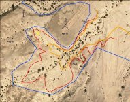
If we are searching the sea limit at about 50 ft ( the limit which they couldn't get out ) over the sea level , east and close to the north end of the mountains , we see a little gulf which has a narrow entrance , turns to the north and is surrounded by high hills . This gulf had deep waters and was the best hideout for the ship . I believe they dropped the anchor in the corner of this gulf to avoid the movement if the waters was rising and left more about 10 ft of the anchor's chain to avoid the sinking .
From my experience in map decrypting , the region fits with the map ( petroglyph ) in the Pinto Canyon . I believe they were in Pinto Canyon maybe because had decided to go to San Diego or were searching for supplies .
I post a GE map of the gulf . With the blue line is the todays 50-51 ft over the sea level water limit , with the orange line is todays 45 ft , and if we consider how in that era the level was about 3 ft deeper , the red line was the navigable limit . You can see on the map the men from the petroglyph and with the yellow X is where I believe is the ship , if ever existed .

Gulf.jpg

Thank you for your patience to read my boring posts . Good luck to everyone .
 

Last edited:

Dvotedwun

Greenie
Nov 1, 2014
12
11
Primary Interest:
All Treasure Hunting
Yes The Petroglyph Posted Erlier in this Thread, Looks to me as if, the Stick figures are Holding both White and Black Pearls, Also looks like one stick figure diving into the water with the pearls (perhaps From an indian boat Deck/Dock) to swim to the Spanish ship and make a getaway, I mean is it me or is it not Obvious?

Anyone else know what im talking about?.

Thanks in advance. :coffee2:
 

markmar

Silver Member
Oct 17, 2012
4,119
6,260
Primary Interest:
All Treasure Hunting
Yes The Petroglyph Posted Erlier in this Thread, Looks to me as if, the Stick figures are Holding both White and Black Pearls, Also looks like one stick figure diving into the water with the pearls (perhaps From an indian boat Deck/Dock) to swim to the Spanish ship and make a getaway, I mean is it me or is it not Obvious?

Anyone else know what im talking about?.

Thanks in advance. :coffee2:


Dvotedwun

You believe the petroglyph was made by the natives and shows the transaction between the Indians and Spaniards when they gave pearls to receive clothes . Could be , but I have another opinion .
Why to swim the Indian if they had a dock ? The entrance to the gulf ( port ) was large ( about 30 yards ) enough for this kind of ship . We should reject the case that the waters was shallow and the ship couldn't reach the dock , because the event occurred when the Salton Sea was about 60 ft over the sea level and the way to the Gulf of California was open . This we can understand because the wounded Captain returned to the base .
I believe was not dock in that gulf . The Indians needed not docks . They had canoes and could enter in the sea from everywhere . And after , why to leave the ship in the hands of the Indians ? For a supplies deal and to guide them to a safe destination ? All are possible , but I believe their souls had not so expensive price for the Spanish King than the pearls . They had to protect the pearls with their lives for the Crown interest , otherwise they would been executed .
I believe the petroglyph shows the region where the ship was left . The ships show where existed water and the stick men show where was land .The man who holds pearls show the direction which they followed after they took some pearls with them ( NW ) . Behind ( to the right ) of the stick man with the pearls is a part of a ship that mean how maybe they covered with sand the ship before they departed .

But this is just my opinion . Please do continue .
 

Last edited:

Dvotedwun

Greenie
Nov 1, 2014
12
11
Primary Interest:
All Treasure Hunting
Interesting perspective, I guess all of which is just Speculation,

After Several years of my own Research, Into how the Salton basin filled and Empty Over Time,
And well one thing is Apparent, There is a Shelf of Land, in the middle that seems to have Risen
Tectonically From Earth Quake's,

There is alot more here Then my Education can Comprehend all at once, i just have a General idea,
(I see it better in my head then i can Explain Right now lol)

I Really wish i Could "translate" let alone see the
Archives thats hold the Log/Manifest of DeIturbe's* Company Ships,

I think i have an idea Here Folks,

I know somewhere out there more localy, someone here in the States have had to use Some Form
Of Ground Penetrating Radar, Perhaps The USGS has some records/Radar Results we can Find n look thru,

I Know in the 29 Palms Area (North of Salton Sea) Folks used an Airplane, to radar survey the Land before building there new Casino, They were concerned
about the land being an Ancient Indian burial Ground, and did not want to build on top if them.

If anythng perhaps we could triangulate the best areas of Possibility's, and Group hire a pilot To do this?. Just a thawt,:icon_scratch:

I am understanding the military has already done this several times, but the info hasnt been used to pin point Ancient ships, just basic topography Training of some sort.
But i doubt obtaining any such information would be possible, who know's? anyone?

All this has got me wondering how many Hieroglyphs / Petroglyph's* go unexamined, Because they are "land Locked" behind BLM / Military Grounds"

Anyhow back to the Topic at hand, There have been more then one road of leads i've personally came across, One Happens to briefly involve Walt Disney, I think i read somewhere, he meet a guy who claimed to find the Ship, i dunno something like that, my guess is he knew something,

Now im not saying there are Clue's thru out the Comic book, but its very very compelling to think Walt knew something tht know one else did,

anyhow heres tht video,, even check outbhow scrooge goes into the town of Indio to appraise the loot. also note ive also heard of death valley containing undergound cities paved with gold roads,, i imagined he found tht to, lol Enjoy.


Crow

Silver Member
Jan 28, 2005
3,331
9,304
In a tax haven some where
Detector(s) used
ONES THAT GO BEEP! :-)
Primary Interest:
Other
Hello Dvotedwun

An unusual idea. Unfortunately the above story Walt Disney had nothing to Do with Uncle scrooge. It was creation of famed cartoonist Carl barks when after leaving Walt Disney in 1942 and joined with western Publishing . Carl barks had a long hard life but he personified the characters with some whats Ironic sense of humor that made them attract not only to children but adults alike. He created many treasure stories with his character. Some times they would win some times he would lose such as an example of real life. His comic stories was the inspiration of many young budding treasure hunter over the years. He produced stories about Incas lost gold mines, Peg leg treasure, lost gold of Maya among others.. He lived to 99 and died in 2000.

However as fun as his work was his stories was drawn from what was already known treasure stories with his fictional twist to them involving his characters.

Crow
 

Last edited:

Dvotedwun

Greenie
Nov 1, 2014
12
11
Primary Interest:
All Treasure Hunting
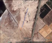
Well folks, I belive i have found someting quite interesting, Im listing a photo of the area, Tell me what you guys think this could be, To me it looks like a Mast sticking out the ground, The sun also seems to be creating shadow for the mast,

Not sure when ide be able to get out to this area as its prob 1hr drive and then 2hr hike, unless off road access is decent enough up to a certain point getting me closer befor ihave to walk,, I believe this to be be the Ship Mertal botts and other Old Tymers Claimed to have Seen, Yup i found something thats for sure, Well off the Beaten Path, desert ship mast.png
 

Last edited:

Dvotedwun

Greenie
Nov 1, 2014
12
11
Primary Interest:
All Treasure Hunting
im having trouble with posting pics, email for a pic if it did ot show up

Thanks
 

Attachments

  • desert ship mast.png
    desert ship mast.png
    324 bytes · Views: 166

Dvotedwun

Greenie
Nov 1, 2014
12
11
Primary Interest:
All Treasure Hunting
indeed good morning, This this is def half buried, i wish i could see better imaging of this area, google only goes in so far,

Know of any other maps i could use,? also wanna see area thru time , and in any image history,
 

Nov 8, 2004
14,582
11,942
Alamos,Sonora,Mexico
Primary Interest:
All Treasure Hunting
Hmmm ., just above see the third from the right, a CLOSED BOX, CLICK ON IT AND IT WILL ASK COMPUTER, YES, THEN BROWSE APPEARS, iNDICATE WHAT YOU WISH TO SEND THEN UPLOAD IT. yOU CAN THEN GO TO YOUR 'SEND' IN MAIL, (INSERT IN oUTLOOK) CLICK ON IT, LOOK FOR WHAT YOU WISH TO SEND _ then click on upload, - RECHECK.

Now about that mast ???????
 

markmar

Silver Member
Oct 17, 2012
4,119
6,260
Primary Interest:
All Treasure Hunting
also, this thing sits on the 33rd parallel ,

I believe the ship is between 32 and 33 parallel , on the east side of the mountais , just south of the US border .

Merry Christmas to everyone !
 

Last edited:

Top Member Reactions

Users who are viewing this thread

Top