The "Peralta" Stone Maps --- On Their Own

cactusjumper

Gold Member
Dec 10, 2005
7,754
5,388
Arizona
Wayne,

I have never been a fan of full-automatic. When I volunteered for a special squad that went after snipers, the old man told me I needed to give up my M-1 Garand for a full-auto....I told him I could put 15 out of 16 rounds in the bulls-eye at rapid fire. He looked at my jacket and told me I was on the squad.

Not many folks carried a Garand in Viet Nam. I, along with a number of older Marines, considered myself lucky.

Take care,

Joe
 

somehiker

Silver Member
May 1, 2007
4,365
6,426
Primary Interest:
All Treasure Hunting
Joe:

Good choice, and one more than a few older marines would have been comfortable with, given the mission.
Would assume,given the possibility of a firefight though, that at least two thirds of the squad carried M16's.
I've never had the opportunity to test an M14, or a M21,( I've used a version similar to the M21) but I did take part in a firepower demonstration where USMC sharpshooters were unofficially competing with their Canadian counterparts. Among our group we had a WW2 vintage sniper version of the Lee Enfield Mk3, an evaluation model of the M-40 Remington 700, and several modified and scoped FNFAL's. Although the weapon is shielded from view in this photo,(it could have been any one of them) I was the subject and at a couple of weeks shy of 18, was the youngest qualified member of the team. The target boards are 1100 yds downrange...if you squint,you can see them at the base of the back berm...and are 4'x4'.
The larger boards along the top are the range lane numbers.
Good practice for shooting crows out of treetops.

View attachment Firepower 1967.bmp

April 1967...Long range demonstration at 1,100 yards.Targets just visible at far end,below backstop with fire-position numbers o

Regards:Wayne

PS: Got a few badges of my own, including my first one with the crossed rifles on it.
Still have my Lt. epaulettes as well as more photos from way back then.
Funny how it is now, that I am usually in the Sups in early April, same time as the photo above was shot by my spotter.
Only now I'm setting the dots on a different kind of target.
 

Last edited:
Jan 2, 2013
4,541
1,971
somewhere between flagstaff, preskit
Detector(s) used
Whites prism III
Primary Interest:
Relic Hunting
That name sounds familiar, was that at the rock shop in Rock Springs. People there used to go up in the Bradshaw's prospecting and metal detecting every weekend of the year.
I've got some old photos of Superior I need to send you some time that will bring back some memories for you I'm sure.

Matthew

yes, those were the people...spent lots of time bench racing in that café.
 

cactusjumper

Gold Member
Dec 10, 2005
7,754
5,388
Arizona
Joe:

Good choice, and one more than a few older marines would have been comfortable with, given the mission.
Would assume,given the possibility of a firefight though, that at least two thirds of the squad carried M16's.
I've never had the opportunity to test an M14, or a M21,( I've used a version similar to the M21) but I did take part in a firepower demonstration where USMC sharpshooters were unofficially competing with their Canadian counterparts. Among our group we had a WW2 vintage sniper version of the Lee Enfield Mk3, an evaluation model of the M-40 Remington 700, and several modified and scoped FNFAL's. Although the weapon is shielded from view in this photo,(it could have been any one of them) I was the subject and at a couple of weeks shy of 18, was the youngest qualified member of the team. The target boards are 1100 yds downrange...if you squint,you can see them at the base of the back berm...and are 4'x4'.
The larger boards along the top are the range lane numbers.
Good practice for shooting crows out of treetops.

View attachment 806706

April 1967...Long range demonstration at 1,100 yards.Targets just visible at far end,below backstop with fire-position numbers o

Regards:Wayne

Wayne,

Our work in Nam was a little closer than that. Everyone in our squad carried a full automatic weapon. It was supposed to be a requirement. I was positioned behind the BAR.

Take care,

Joe
 

somehiker

Silver Member
May 1, 2007
4,365
6,426
Primary Interest:
All Treasure Hunting
Joe:
While I can't swap any Nam stories, having made other decisions when the time came, I can recall standing at the rear of a number of Marines who were lighting up their targets with BAR's one night. Loved the tracers and the way they would ricochet when they hit the hard stuff. You might have one of these laying around . I'd have the gun to go with it, but there's no place outdoors where you can put it to use in my area, and too much hassle to even get a permit to buy one.

View attachment m16 man.bmp

Regards:SH.
 

cactusjumper

Gold Member
Dec 10, 2005
7,754
5,388
Arizona
Joe:
While I can't swap any Nam stories, having made other decisions when the time came, I can recall standing at the rear of a number of Marines who were lighting up their targets with BAR's one night. Loved the tracers and the way they would ricochet when they hit the hard stuff. You might have one of these laying around . I'd have the gun to go with it, but there's no place outdoors where you can put it to use in my area, and too much hassle to even get a permit to buy one.

View attachment 806726

Regards:SH.

Wayne,

Good that you enjoyed the light show. You had a nice place to watch it from. Looks a little different laying on your back while they create a solid line in the night-sky above you.

Want to hear some good war stories, ask Kraig/Matthew. I understand he has three purple hearts from that party.:dontknow:

Take care,

Joe
 

Nov 8, 2004
14,582
11,942
Alamos,Sonora,Mexico
Primary Interest:
All Treasure Hunting
SH, in 42 I made the mistake of shoving tracers in my 1903 Springfield while on inner perimeter patrol. My first shot, late at night, brought more Marine return fire than from the ****.

Later when I asked them why they had fired on me, since I was 'with' them, they replied, "ya stupid swabby, when you fired that tracer it located our position for the ****. If you ever do that again, we will personally cut em off if you survive".

Incidentally, that Springfield had to have come from a museum. It was # 123 and had a star guaged barrel.

I tried to bring it back to the US, but some thieving Jarhead stole it from me before I could steal it myself. He knew it's value.

They also issued me a S&W revolver that used the .45 acp ball ammo from WW -I, it didn't need the half moon clips. They stole that also.

Don Jose de La Mancha

p.s. Edited cause I see that we are politically correct here, since two of my words were substituted / deleted. You should hear what they called 'me' in the night. :censored:
 

Last edited:

somehiker

Silver Member
May 1, 2007
4,365
6,426
Primary Interest:
All Treasure Hunting
"p.s. Edited cause I see that we are politically correct here, since two of my words were substituted / deleted. You should hear what they called me in the night.
censored.gif
"

I hope it wasn't "sweetie"....
 

peralta

Sr. Member
Sep 28, 2011
389
45
oahu hawaii
Detector(s) used
Whites 2-box
Primary Interest:
All Treasure Hunting
Hal,

Yes, I have lived here in Southern California for several years now, work requires I located here but plan to return to Arizona when I finally retire. Yes, I still hike the mountains every chance I can get, just was on a great hike with Jack Carlson, Dick Walp, Greg Davis, Roger Newkirk and Brian Lickman out through Garden Valley and points beyond. Yes, I'm definitely looking forward to the 2013 Rendezvous, I've missed a few of them but always because I was out in the mountains during the days the Rendezvous fell. I always camp with Greg Davis, Clay Worst, Jack, Roger, Peter Esposito and several other old Dutch Hunters so drop by and it will be great to meet you and talk.

The BLM claim map I posted is the one from 1983, the one Mike and friends filed in January 1983 before the filing deadline for the Wilderness Act. The one I'm looking for, and is more relevant is the earlier 1980 filing, not the "LDM" claims. There is a twist to the Bilbry claims and filings. Hopefully I can find it and post it before I have to leave today for San Diego. I don't get to look in and post every day but am off for the Memorial Day weekend.

Matthew K. Roberts

The stone crosses and the latin hearts are true markings to treasure.The crosses are used after you locate one of the peralta treasures.it gave me the digging location . The location of the latin hearts are used with the peralta and Santa Maria documents.
Tom
 

somehiker

Silver Member
May 1, 2007
4,365
6,426
Primary Interest:
All Treasure Hunting
The stone crosses and the latin hearts are true markings to treasure.The crosses are used after you locate one of the peralta treasures.it gave me the digging location . The location of the latin hearts are used with the peralta and Santa Maria documents.
Tom

Tom:
What ARE these "peralta treasures" you speak of ??
You said a while back that you were selling your "digging locations" to a mining company.
What have THEY found...?

Regards:SH.
 

somehiker

Silver Member
May 1, 2007
4,365
6,426
Primary Interest:
All Treasure Hunting
Marius:

I think Peralta is talking about a different area entirely. Maybe even the same area as "Not Peralta".

I know I disapoint a lot of people by saying it but its up to each individual if they believe it.to find the reassure mines stay out of the superstition mountains.you know where the stones were recovered so everyone assumed it had to be closeby. Why were they put in the middle of nowhere?did they bring them from a mission like santa Maria which is across the border? Was there an unknown vista near the site?where was everyones marker, the nearby peak? There are hundreds of peaks in Arizona.is it related to the Dutchman?only if he traveled to my treasure locating.you can't assume something just because everybody else thinks so.everyone is then searching where the three X markers are in miles and in reality they are only distanced apart in catastrophe and they are marked with Xs just like the map shows.now I will probably be ridiculed but that's ok.its just that everyone has covered the mountains for, are ex imarine just blowing smoke.my ancestors are from Arizona and I was also told treasure stories by my grandfather. Good luck, good hunting.ilwer meaningful qu

http://www.treasurenet.com/forums/g...ocation-found-but-not-superstition-mount.html

Regards:SH.
 

somehiker

Silver Member
May 1, 2007
4,365
6,426
Primary Interest:
All Treasure Hunting
I've had a number of exchanges with Tom as well, Marius.
And it's hard to tell where he is, from one to the next.
He often asks if I saw his pictures that he sent, but when I tell him I never got them, he drops the conversation.
Regards:SH
 

Hal Croves

Silver Member
Sep 25, 2010
2,659
2,695
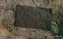
When this image is superimposed onto an aerial photograph of the corresponding location, at the correct scale and orientation, it reveals directional instructions. They are clear and confirmed by very specific features in the aerial photograph. Do not take my word for it. Study the system of treasure symbols, think about the rules and how they were and could be used. There is more to this stone map, but this is a good place to begin.

View attachment 807583


White is the intended travel route.
Green GOTO lines of the symbol "A".
Yellow EWNS.
Blue direction to the Salt.
Red change direction.
Magenta anomalies.​


The key will be the horses right ear. It is the registration mark that determines scale and position. It is there, in the aerial. Just look for it. Remember that in this theory, the maps (combined) northern boarder is the Salt with Weavers to the south.

As I have said before. Even when the correct placement is made, there will be hours and hours of thinking to do.
 

393stroker

Hero Member
Jun 27, 2012
505
789
HOUSTON
Detector(s) used
Garrett pro-something
Primary Interest:
All Treasure Hunting
When this image is superimposed onto an aerial photograph of the corresponding location, at the correct scale and orientation, it reveals directional instructions. They are clear and confirmed by very specific features in the aerial photograph. Do not take my word for it. Study the system of treasure symbols, think about the rules and how they were and could be used. There is more to this stone map, but this is a good place to begin.

View attachment 807583


White is the intended travel route.
Green GOTO lines of the symbol "A".
Yellow EWNS.
Blue direction to the Salt.
Red change direction.
Magenta anomalies.​


The key will be the horses right ear. It is the registration mark that determines scale and position. It is there, in the aerial. Just look for it. Remember that in this theory, the maps (combined) northern boarder is the Salt with Weavers to the south.

As I have said before. Even when the correct placement is made, there will be hours and hours of thinking to do.
Maybe something like this? HORSE.jpg I noticed that it looks like a straight edge was used to align some of the markings on the trail map also.
 

Last edited:

Hal Croves

Silver Member
Sep 25, 2010
2,659
2,695
Maybe something like this? View attachment 807594 I noticed that it looks like a straight edge was used to align some of the markings on the trail map also.

Not quite. Your scale is off.
I gave the scale of this map in an earlier post.
Remember also that the white lines are the "intended" direction of travel. NOT a literal translation of the trail.
Check your scale and you will get it.....

But once you do, think about what might happen to these sites once you make your discovery public.
That is, if this theory is correct.
 

Hal Croves

Silver Member
Sep 25, 2010
2,659
2,695
Hal

The scale is very big . Is like you are seeking a needle in the barn . Remember ( IMO ) how the author saw the horse ( and the other stone maps ) from a high point and not farest of 2,5 miles radius .

Marius

Four maps that cover an area from the Salt River to Weavers Needle.
That is smaller than most topos.

That high point you are describing was at about 12" above his desk.

Which map do you believe Ruth was working from? I mean, do you think the actual map exists?
In my theory, Ruth is connected to the stones, but only indirectly.
 

Top Member Reactions

Users who are viewing this thread

Latest Discussions

Top