OP
OP
EE THr
Silver Member
- Thread starter
- #1,381
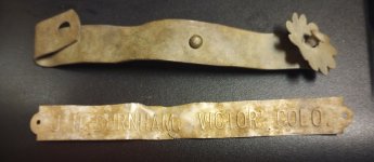
Go back two pages in this thread , to the #1311 post . There is a picture with the horse and some explanations .
The only problem with your "match" is that there is nothing on the ground, in your image there, that even remotely resembles a horse or it's head.
How do you reconcile that?