You are using an out of date browser. It may not display this or other websites correctly.
You should upgrade or use an alternative browser.
You should upgrade or use an alternative browser.
The Peralta Stone Maps, Real Maps to Lost Gold Mines or Cruel Hoax?
- Thread starter Oroblanco
- Start date
sgtfda
Bronze Member
I'm always cautious of those who can't find the gold but want you to buy a book on their theory of where it is. Is it just me or am I missing something. The only books I value are written by Tom G and Tom K.
markmar
Silver Member
- Oct 17, 2012
- 4,122
- 6,269
- Primary Interest:
- All Treasure Hunting
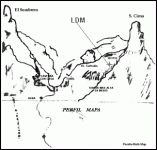
The two Peralta's mines close to the LDM are recognized in Perfil mapa with the " TUNEL " and " HOYO " . These are the mines which Peralta had marked with a pictograph on a stone close to the Weaver's Needle . The LDM is closer and below to the " HOYO " and I believe is the same vein but with different percent ( bigger ) of gold .

I believe Peralta never said to Waltz about the other 5 mines of the Latin heart which were marked with a pictograph on stone few miles north from the other pictograph marking .
I believe Reavis used fraudulent documents ( after 1864 ) to obtain the Peralta's grant . I believe how the original document of the grant which for sure had the Peraltas ( for excuse ) in the last trip in 1854 , in mysterious circumstances ( not so if they fell in the " Yankees " hands ) was optained after 10 years with deed by Mr. Willing .
Cristobal Peralta didn't knew about this deed and searched for property title after 70 years ? Something don't fit .
johnmark29020
Sr. Member
The two Peralta's mines close to the LDM are recognized in Perfil mapa with the " TUNEL " and " HOYO " . These are the mines which Peralta had marked with a pictograph on a stone close to the Weaver's Needle . The LDM is closer and below to the " HOYO " and I believe is the same vein but with different percent ( bigger ) of gold .
<img src="http://www.treasurenet.com/forums/attachment.php?attachmentid=1034789"/>
I believe Peralta never said to Waltz about the other 5 mines of the Latin heart which were marked with a pictograph on stone few miles north from the other pictograph marking .
I believe Reavis used fraudulent documents ( after 1864 ) to obtain the Peralta's grant . I believe how the original document of the grant which for sure had the Peraltas ( for excuse ) in the last trip in 1854 , in mysterious circumstances ( not so if they fell in the " Yankees " hands ) was optained after 10 years with deed by Mr. Willing .
Cristobal Peralta didn't knew about this deed and searched for property title after 70 years ? Something don't fit .
I was at this location in march, i have some bad pics of it. Most of the handrawn maps seem to lead to that same location. The trail map goes there as well. I wasnt expecting to find the stone house still standing,but it still there.when I was at the stone house. A tour guide brought a bunch up to the house. He was telling them. No one knows who built it. I was sitting there cracking up. The house cannon and mine are identical to the stone trail map. I followed the cannon side straight to the needle. The imaginary circle,the el sombrero, and the laurals thicket. The three iron wood stumps ,and tanks mentioned in the holmes manuscipt,and the one arm catus.,
The one thing I found off was the swirl marker thats supposed to be on the mountain. There was a hugh cross instead. The swirl marker is on a mountain at the other location. Thats been puzzling me.
I would have gotten more done except for a injury,and two big guys who showed up on motorcycles. I didnt want to get shot. Im goinh back in October. We all should get together to form a real search.
We could search each spot at the same time. I could use some expert advise. I really want to explore the skull cave,but with my health I need some young bucks. The skull cave is going to be very tricky. Ironically because of where it located. It sets in the shadow for most of the day. I was useing google to look at it during different times of the day. Morning and afternoon seem to be shadowed. Noon to four is when it can be seen the best, but I need to go back and see it for real to be sure. There is a ebook where this guy claims that the perfil map is red mountain. He says that the one half of the map is red mountain from the south and the other half is red moutain from the north. His book made me laugh.
Last edited:
deducer
Bronze Member
- Jan 7, 2014
- 2,282
- 4,365
- Primary Interest:
- Other
I was at this location in march, i have some bad pics of it. Most of the handrawn maps seem to lead to that same location. The trail map goes there as well. I wasnt expecting to find the stone house still standing,but it still there.when I was at the stone house. A tour guide brought a bunch up to the house. He was telling them. No one knows who built it. I was sitting there cracking up. The house cannon and mine are identical to the stone trail map. I followed the cannon side straight to the needle. The imaginary circle,the el sombrero, and the laurals thicket. The three iron wood stumps ,and tanks mentioned in the holmes manuscipt,and the one arm catus.,
The one thing I found off was the swirl marker thats supposed to be on the mountain. There was a hugh cross instead. The swirl marker is on a mountain at the other location. Thats been puzzling me.
I would have gotten more done except for a injury,and two big guys who showed up on motorcycles. I didnt want to get shot. Im goinh back in October. We all should get together to form a real search.
We could search each spot at the same time. I could use some expert advise. I really want to explore the skull cave,but with my health I need some young bucks. The skull cave is going to be very tricky. Ironically because of where it located. It sets in the shadow for most of the day. I was useing google to look at it during different times of the day. Morning and afternoon seem to be shadowed. Noon to four is when it can be seen the best, but I need to go back and see it for real to be sure. There is a ebook where this guy claims that the perfil map is red mountain. He says that the one half of the map is red mountain from the south and the other half is red moutain from the north. His book made me laugh.
If I read this right, two big guys showed up on motorcycles at Weaver's needle?
johnmark29020
Sr. Member
No not weavers needle, its a needle shaped rock. It looks alot like the waltz doodle that people think is weavers needle. The holmes map shows it well. Those mountains on the map are in reality rocks. Very large rocks.
Eldo
Banned
- Jul 7, 2014
- 1,890
- 698
- Detector(s) used
- Brain, Pointing Finger, occasionally the Pinky Finger
- Primary Interest:
- All Treasure Hunting
No not weavers needle, its a needle shaped rock. It looks alot like the waltz doodle that people think is weavers needle. The holmes map shows it well. Those mountains on the map are in reality rocks. Very large rocks.
he said you have to look "through the 'eye' of the needle"
an eye is horizontal......so is a needle when laid flat...you guys keep thinking that its the Weaver's needle area........ludicrous and obvious when all his clues are wrapped in mystery and cunning.
the other clue..."no miner will find my mine"......he says this in relation to the Miner's Needle area to say its in another area altogether......he was from McDowell Mountain and wouldnt necessarily come to massacre point area if he could get his near the saguaro dam goldfield mines......
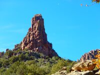
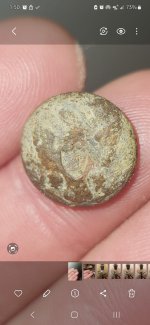
this is on my solve trail..........the kissing elephants .......or the fornix on the peralta heart stone descriptions
View attachment 1035459 View attachment 1035462
Last edited:
sgtfda
Bronze Member
How do you know what Waltz said? Say amen the preacher cries. Forget about the clues. Find it the way Waltz did. Follow the gold.
johnmark29020
Sr. Member
he said you have to look "through the 'eye' of the needle"
an eye is horizontal......so is a needle when laid flat...you guys keep thinking that its the Weaver's needle area........ludicrous and obvious when all his clues are wrapped in mystery and cunning.
the other clue..."no miner will find my mine"......he says this in relation to the Miner's Needle area to say its in another area altogether......he was from McDowell Mountain and wouldnt necessarily come to massacre point area if he could get his near the saguaro dam goldfield mines......
this is on my solve trail..........the kissing elephants .......or the fornix on the peralta heart stone descriptions
<img src="http://www.treasurenet.com/forums/attachment.php?attachmentid=1035459"/><img src="http://www.treasurenet.com/forums/attachment.php?attachmentid=1035462"/>
I dont have the experience that you guys have in the search, but I believe waltz told them exactly where the mine laid. He wanted his friend to have the gold. His directions where clear. At least to him. Similar to a experienced electrician try to explain blue prints to a helper. When its located. The finder will be able to explain most if not all of the directions.
I dont understand why so many people think Waltzs mine is up north.
There is so much that indicates that he was down south.
I stood at the perfil map location in march. It looks like the map. Then I found the other perfil map location.
It looks just like the map,with one exception. I thought both of those maps where the same place,but they werent. No after reading a post about charles kenworthy I understand some of the markers I saw better.
somehiker
Silver Member
- May 1, 2007
- 4,365
- 6,428
- Primary Interest:
- All Treasure Hunting
Ahhh. Could it be that there WAS three mines after all ?
The first, which Waltz and Weiser were led to and worked with Peralta....the one which they helped him to cover up/conceal before returning with him to his home, where he traded their share of the proceeds for his claim to the mine.
And on their return to the mountains, presumably after resupplying (where?)
The second, where Waltz and Weiser killed the two men who they thought were indians, and where Waltz and Weiser were themselves attacked by the Apache or Yavapai. A mine which Waltz had returned to when his mule and supplies were stolen.
The third, and the richest, where Waltz "lost it" and murdered the three Mexicans miners who had helped him after his kit was stolen.
I think we can assume that he was headed back to home base, or possibly Ft. McDowell or Picketpost, when he came across the Mexican's camp.
Can the stories and clues be sorted out on this basis, in such a way as to give a new and better understanding of Waltz's history and wish that his friends benefit from his mine(s) ?
johnmark29020
Sr. Member
Ahhh. Could it be that there WAS three mines after all ?
The first, which Waltz and Weiser were led to and worked with Peralta....the one which they helped him to cover up/conceal before returning with him to his home, where he traded their share of the proceeds for his claim to the mine.
And on their return to the mountains, presumably after resupplying (where?)
The second, where Waltz and Weiser killed the two men who they thought were indians, and where Waltz and Weiser were themselves attacked by the Apache or Yavapai. A mine which Waltz had returned to when his mule and supplies were stolen.
The third, and the richest, where Waltz "lost it" and murdered the three Mexicans miners who had helped him after his kit was stolen.
I think we can assume that he was headed back to home base, or possibly Ft. McDowell or Picketpost, when he came across the Mexican's camp.
Can the stories and clues be sorted out on this basis, in such a way as to give a new and better understanding of Waltz's history and wish that his friends benefit from his mine(s) ?
Its starting to look that way. Thanks for the link. Its been very helpful.
markmar
Silver Member
- Oct 17, 2012
- 4,122
- 6,269
- Primary Interest:
- All Treasure Hunting
Ahhh. Could it be that there WAS three mines after all ?
The first, which Waltz and Weiser were led to and worked with Peralta....the one which they helped him to cover up/conceal before returning with him to his home, where he traded their share of the proceeds for his claim to the mine.
And on their return to the mountains, presumably after resupplying (where?)
The second, where Waltz and Weiser killed the two men who they thought were indians, and where Waltz and Weiser were themselves attacked by the Apache or Yavapai. A mine which Waltz had returned to when his mule and supplies were stolen.
The third, and the richest, where Waltz "lost it" and murdered the three Mexicans miners who had helped him after his kit was stolen.
I think we can assume that he was headed back to home base, or possibly Ft. McDowell or Picketpost, when he came across the Mexican's camp.
Can the stories and clues be sorted out on this basis, in such a way as to give a new and better understanding of Waltz's history and wish that his friends benefit from his mine(s) ?
Wayne
I believe the story with the three Mexicans is fiction . IMO , they killed the two when they ( Waltz , Weiser and Perealta ) went the first time to the one from the two mines existed on that mountainside . The third ( LDM ) was opened after by Waltz when he remained alone . He discovered the golden ledge below the mountain wall and had presumed how little above was the mother lode or a richest vein than in the mine little higher . The mines are all on the same mountainside . Something like Tayopa .
johnmark29020
Sr. Member
Wayne
I believe the story with the three Mexicans is fiction . IMO , they killed the two when they ( Waltz , Weiser and Perealta ) went the first time to the one from the two mines existed on that mountainside . The third ( LDM ) was opened after by Waltz when he remained alone . He discovered the golden ledge below the mountain wall and had presumed how little above was the mother lode or a richest vein than in the mine little higher . The mines are all on the same mountainside . Something like Tayopa .[/
I have been locating treasure symbols pointing south. Bird hearts just to name two.
Kinda like the mines went up one side and down the other.
Does anyone know if the reavis ranch is still standing.
I saw a pic from the 70s and thought I might check it out. The next time Im in az. It amazes me that there is a ranch in those mtns. Must have been a quite little place.
- Jun 27, 2012
- 505
- 789
- Detector(s) used
- Garrett pro-something
- Primary Interest:
- All Treasure Hunting
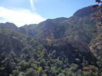
A picture I took up by Rough Canyon looking back at the needle looks a lot like the Perfil map area.


The two Peralta's mines close to the LDM are recognized in Perfil mapa with the " TUNEL " and " HOYO " . These are the mines which Peralta had marked with a pictograph on a stone close to the Weaver's Needle . The LDM is closer and below to the " HOYO " and I believe is the same vein but with different percent ( bigger ) of gold .
View attachment 1034789
I believe Peralta never said to Waltz about the other 5 mines of the Latin heart which were marked with a pictograph on stone few miles north from the other pictograph marking .
I believe Reavis used fraudulent documents ( after 1864 ) to obtain the Peralta's grant . I believe how the original document of the grant which for sure had the Peraltas ( for excuse ) in the last trip in 1854 , in mysterious circumstances ( not so if they fell in the " Yankees " hands ) was optained after 10 years with deed by Mr. Willing .
Cristobal Peralta didn't knew about this deed and searched for property title after 70 years ? Something don't fit .
somehiker
Silver Member
- May 1, 2007
- 4,365
- 6,428
- Primary Interest:
- All Treasure Hunting
It was quite the place, but it burned down many years ago. Some concrete pads and sections of the red sandstone porch and foundation are still there.
A hexagonal walled stock tank or hot tub too. Might be some apples in the orchard as well, but probably still green. Make sure you have tp before you eat any. Keep an eye out for bears.
What's a "bird heart" symbol look like ?
A hexagonal walled stock tank or hot tub
 too. Might be some apples in the orchard as well, but probably still green. Make sure you have tp before you eat any. Keep an eye out for bears.
What's a "bird heart" symbol look like ?
johnmark29020
Sr. Member
It was quite the place, but it burned down many years ago. Some concrete pads and sections of the red sandstone porch and foundation are still there.
A hexagonal walled stock tank or hot tubtoo. Might be some apples in the orchard as well, but probably still green. Make sure you have tp before you eat any. Keep an eye out for bears.
What's a "bird heart" symbol look like ?
Its was supposed to read birds,hearts. There is a large stone bird,and a couple of hearts. The bird tells the direction I think. The heart is carved below the bird. If im reading it right. It say heart. Is south. Which is one of my location.
markmar
Silver Member
- Oct 17, 2012
- 4,122
- 6,269
- Primary Interest:
- All Treasure Hunting
A picture I took up by Rough Canyon looking back at the needle looks a lot like the Perfil map area. View attachment 1036250
Chuck
Also , I can't see a needle rock ( or two like in the Perfil map ) in the skyline .
- Jun 27, 2012
- 505
- 789
- Detector(s) used
- Garrett pro-something
- Primary Interest:
- All Treasure Hunting
johnmark29020
Sr. Member
When I get back to az. I will test my theory. I will know then what works and what doesnt. Until then its all theory. The last time I had to throw out about half. Cant wait to get more boots on the ground.
Top Member Reactions
-
 1924
1924 -
 1130
1130 -
 1107
1107 -
 959
959 -
 949
949 -
 850
850 -
 845
845 -
 818
818 -
 785
785 -
 738
738 -
 455
455 -
 443
443 -
 402
402 -
 359
359 -
E
358
-
 328
328 -
 326
326 -
 317
317 -
 312
312 -
 293
293
Users who are viewing this thread
Total: 2 (members: 0, guests: 2)


