Things For Further Research

sdcfia

Silver Member
Sep 28, 2014
3,663
8,899
Primary Interest:
Other
That is the thing sdcfia, there is no hole anywhere, just a pile of dirt and small stones with weeds in the middle of a wooded area with some pretty large trees around it..:dontknow:

Ooops, sorry - I misread your post. Well, a 3-4' pile of rocks and dirt could also have multiple explanations, depending on how large (small conical heap, larger platform, etc) the pile is, how flat the surrounding terrain is, its apparent age, and so on. Might be a sighting device, a trail marker, a surveyor's control point, a map node, a homesteader's boundary marker, a grave, and probably other things. I imagine you looked at all the stones for marks on them.
 

OP
OP
M

mdog

Bronze Member
Mar 22, 2011
2,357
4,410
Sdcfia, Rebel and L.C., thank you very much for sharing information and contributing to the thread. :thumbsup:
 

L.C. BAKER

Silver Member
Sep 9, 2012
3,805
4,643
Nebraska City, Nebraska
Primary Interest:
Other
Ooops, sorry - I misread your post. Well, a 3-4' pile of rocks and dirt could also have multiple explanations, depending on how large (small conical heap, larger platform, etc) the pile is, how flat the surrounding terrain is, its apparent age, and so on. Might be a sighting device, a trail marker, a surveyor's control point, a map node, a homesteader's boundary marker, a grave, and probably other things. I imagine you looked at all the stones for marks on them.

We have a lot of things to still do and try at that point, thanks for the ideas. I will try to find a picture of it I took last Summer and post it. I should go back and get some good pictures while there is no cover on the trees and ground. It is next to a creek and simi flat. There is no doubt that the mass of earth is a man made object of some kind.:thumbsup:
 

Last edited:
OP
OP
M

mdog

Bronze Member
Mar 22, 2011
2,357
4,410
Here's one for further research. On page 159 of his book, New Mexico Confidential, Steve writes about the Mystery Glyph Stones that are located at many sites across the American west.

Mystery Glyphs - Home

A friend gave me the locations of almost two dozen of these stones but, from what I understand, the man who has done the most research on these stones doesn't want any locations revealed so I will honor his wishes.

From what I've seen, I would guess these stones were probably carved during the late 1800's or early 1900's and the carvings were made at specific sites that formed huge straight line and triangular patterns. These lines and triangles also include well known treasure sites and place names such as the names Steve and I have written about. The triangles formed are right triangles and near equilateral triangles. When I say near equilateral, I mean two sides are almost exact and the third is not. I think this was done to show a base location. Anyway, back to the Glyph Stones. The best lines I've seen, using these glyphs, start at Oak Island and continue on past each individual stone to the western border of the U.S. Three treasure sites that grabbed my attention were Black Mesa in New Mexico, Marble Mountain in Colorado and Wildcat Mountain in Wisconsin.

Good luck if any of you research these stones.
 

kanabite

Hero Member
May 27, 2006
549
368
southern utah
Detector(s) used
wander aimlessly in circles with camera in hand
Primary Interest:
All Treasure Hunting
Here's one for further research. On page 159 of his book, New Mexico Confidential, Steve writes about the Mystery Glyph Stones that are located at many sites across the American west.

Mystery Glyphs - Home


A friend gave me the locations of almost two dozen of these stones but, from what I understand, the man who has done the most research on these stones doesn't want any locations revealed so I will honor his wishes.

From what I've seen, I would guess these stones were probably carved during the late 1800's or early 1900's and the carvings were made at specific sites that formed huge straight line and triangular patterns. These lines and triangles also include well known treasure sites and place names such as the names Steve and I have written about. The triangles formed are right triangles and near equilateral triangles. When I say near equilateral, I mean two sides are almost exact and the third is not. I think this was done to show a base location. Anyway, back to the Glyph Stones. The best lines I've seen, using these glyphs, start at Oak Island and continue on past each individual stone to the western border of the U.S. Three treasure sites that grabbed my attention were Black Mesa in New Mexico, Marble Mountain in Colorado and Wildcat Mountain in Wisconsin.

Good luck if any of you research these stones.


I
could find out the wishes of this guy you are talking about ,if you like? Lol
Sorry to doubt you here but I am having a hard time with 26 or so sites in the western united states having anything to do with oak island.
 

OP
OP
M

mdog

Bronze Member
Mar 22, 2011
2,357
4,410
I've had a couple of posts on this thread about lines and geometric patterns that, sometime, cover hundreds and even thousands of miles. Why would anybody do such a thing, you might ask. That is a question easy to answer. Man has been doing such things for thousands of years. If there was ever an opportunity for man to leave his mark on the landscape, he took it. From the most powerful king to the poorest of the poor, people like to look at something and say, "Hey man, I put that there. That's mine." It might be a magnificent pyramid or some initials carved on a rock. Everybody wants to leave their mark. If you want to get a little mysterious about it, you can do that too. Just go to your cemetery of choice and buy three plots and make sure they are spaced far enough apart so that you can form a huge right or equilateral triangle. Then, go buy yourself three cheap tombstones and have something mysterious or cryptic put on them. There you go. Fifty years after your dead somebody will come along and notice the tombstones and figure out that two of the graves are empty and you must have belonged to some secret society and there has to be a treasure somewhere around here.

I think the lines and place names are a way for some large and well organized group to do the same thing. My guess would be a large organization that is into geometry big time. Maybe not necessarily for some sinister reason but to teach and learn different skills. Skills like navigation, surveying, math, organization and logistics, persuasion, psychology, all kinds of stuff. Besides it would have been something for the 19th century tech geeks to do while they were waiting around to go online. As for the treasure stuff, maybe there's something to that, maybe not. Nothing grabs attention like a good treasure story.
 

OP
OP
M

mdog

Bronze Member
Mar 22, 2011
2,357
4,410
I
could find out the wishes of this guy you are talking about ,if you like? Lol
Sorry to doubt you here but I am having a hard time with 26 or so sites in the western united states having anything to do with oak island.

That's ok, Kanabite. I've been studying this stuff for a couple of years and I'm ready to go back to hunting arrowheads. I want to get this stuff written down in case anybody else might find it useful. Pass it on, so to speak.
 

kanabite

Hero Member
May 27, 2006
549
368
southern utah
Detector(s) used
wander aimlessly in circles with camera in hand
Primary Interest:
All Treasure Hunting
Oh I get that .I've drawn one about 1800 miles long on GE ,ended up at the serpent mound in Ohio on it .figured they were ley lines and probably way above my pay grade.lmao
Oh there is something to this IMO , but im thinking it is far larger than some KGC cache .
Steve has said many times he believed that much of this treasure stuff is modern and that could be in some cases ,but things I have seen make me tend to believe that some of these more Masonic types were chasing something else. But hey its just an opinion.
 

Rebel - KGC

Gold Member
Jun 15, 2007
21,680
14,739
I've had a couple of posts on this thread about lines and geometric patterns that, sometime, cover hundreds and even thousands of miles. Why would anybody do such a thing, you might ask. That is a question easy to answer. Man has been doing such things for thousands of years. If there was ever an opportunity for man to leave his mark on the landscape, he took it. From the most powerful king to the poorest of the poor, people like to look at something and say, "Hey man, I put that there. That's mine." It might be a magnificent pyramid or some initials carved on a rock. Everybody wants to leave their mark. If you want to get a little mysterious about it, you can do that too. Just go to your cemetery of choice and buy three plots and make sure they are spaced far enough apart so that you can form a huge right or equilateral triangle. Then, go buy yourself three cheap tombstones and have something mysterious or cryptic put on them. There you go. Fifty years after your dead somebody will come along and notice the tombstones and figure out that two of the graves are empty and you must have belonged to some secret society and there has to be a treasure somewhere around here.

I think the lines and place names are a way for some large and well organized group to do the same thing. My guess would be a large organization that is into geometry big time. Maybe not necessarily for some sinister reason but to teach and learn different skills. Skills like navigation, surveying, math, organization and logistics, persuasion, psychology, all kinds of stuff. Besides it would have been something for the 19th century tech geeks to do while they were waiting around to go online. As for the treasure stuff, maybe there's something to that, maybe not. Nothing grabs attention like a good treasure story.
Sounds like the World Grid System of Ley Lines, to me...
 

sdcfia

Silver Member
Sep 28, 2014
3,663
8,899
Primary Interest:
Other
I've had a couple of posts on this thread about lines and geometric patterns that, sometime, cover hundreds and even thousands of miles. Why would anybody do such a thing, you might ask. That is a question easy to answer. Man has been doing such things for thousands of years. If there was ever an opportunity for man to leave his mark on the landscape, he took it. From the most powerful king to the poorest of the poor, people like to look at something and say, "Hey man, I put that there. That's mine." It might be a magnificent pyramid or some initials carved on a rock. Everybody wants to leave their mark. If you want to get a little mysterious about it, you can do that too. Just go to your cemetery of choice and buy three plots and make sure they are spaced far enough apart so that you can form a huge right or equilateral triangle. Then, go buy yourself three cheap tombstones and have something mysterious or cryptic put on them. There you go. Fifty years after your dead somebody will come along and notice the tombstones and figure out that two of the graves are empty and you must have belonged to some secret society and there has to be a treasure somewhere around here.

I think the lines and place names are a way for some large and well organized group to do the same thing. My guess would be a large organization that is into geometry big time. Maybe not necessarily for some sinister reason but to teach and learn different skills. Skills like navigation, surveying, math, organization and logistics, persuasion, psychology, all kinds of stuff. Besides it would have been something for the 19th century tech geeks to do while they were waiting around to go online. As for the treasure stuff, maybe there's something to that, maybe not. Nothing grabs attention like a good treasure story.

Brilliant post mdog. People ought to print it and refer to it often. I have a couple comments.

First: just because you find a couple piles of rocks or a carving somewhere doesn't mean you're on the "treasure trail". These things are everywhere and have many innocent purposes. Some have even been created by pranksters in the past few decades. All you have to do is get yourself a nice cold chisel and a three-pound hammer, go find a big rock where people hike near, and carve an arrow, cross, turtle, etc. If the rock is the right kind, you can then use a fine rasp, some emory cloth, etc, and do a decent job of "weathering it". People will notice your creation, and eventually, someone will wonder if it's "Spanish". In time, a legend will be born. Heck, I saw something similar happen with a simple real estate transaction near Silver City several years ago - and there was no hoaxing involved. A guy was walking around and found a carved stone near an old fence line. He was sure it was a treasure map. It wasn't - it was a surveyor's corner from the 1800s. They used carved stones then, sometimes intricate. The guy found the property owner and bought the land where he figured the treasure was buried. Then he began digging dozens of holes all over the place for years. My surveying buddy told him he was wasting his time, but the guy couldn't believe it. He's probably still digging if he hasn't died trying.

Second: Re more "legitimate" treasure signs. I've seen a lot of obviously well-engineered patterns of clues that accompany "treasure legends" (well-known and not so well-known). You've showed me some amazing large-scale map patterns that boggle the imagination. We want to assume that this stuff was created to hide big time treasure caches, and maybe they were. Or not. I was told by a very smart guy some years ago that these "KGC layouts" may be simply a learning opportunity for curious folks and that there may be no pots of gold at the ends of the rainbows - only the knowledge gained on the journey. When you think about it, a guy has to keep educating himself in order to keep chasing down these things. Or, maybe the whole thing is some sort of initiation exercise for some group of folks. Whatever it is, you find yourself studying up on all sorts of things - history, genealogy, ancient cultures, geometry, cartography, symbology, philosophy and more. That can't be bad for you, and like you said - you don't really need to find gold bars. It's still a thrill to find just a little old arrowhead.
 

sdcfia

Silver Member
Sep 28, 2014
3,663
8,899
Primary Interest:
Other
Sounds like the World Grid System of Ley Lines, to me...

Lindahl thinks that ley lines are not naturally occurring "earth currents" that attracted man to build on, but that man built structures in geometric patterns first, and the earth currents were then caused by the structures and the vibrations of those people who used them.
 

Rebel - KGC

Gold Member
Jun 15, 2007
21,680
14,739
Lindahl thinks that ley lines are not naturally occurring "earth currents" that attracted man to build on, but that man built structures in geometric patterns first, and the earth currents were then caused by the structures and the vibrations of those people who used them.
Nicely "stated"... HOWEVER! World Grid System (aka WGS) goes "over" oceans, seas, ponds, etc.
 

OP
OP
M

mdog

Bronze Member
Mar 22, 2011
2,357
4,410
Brilliant post mdog. People ought to print it and refer to it often. I have a couple comments.

First: just because you find a couple piles of rocks or a carving somewhere doesn't mean you're on the "treasure trail". These things are everywhere and have many innocent purposes. Some have even been created by pranksters in the past few decades. All you have to do is get yourself a nice cold chisel and a three-pound hammer, go find a big rock where people hike near, and carve an arrow, cross, turtle, etc. If the rock is the right kind, you can then use a fine rasp, some emory cloth, etc, and do a decent job of "weathering it". People will notice your creation, and eventually, someone will wonder if it's "Spanish". In time, a legend will be born. Heck, I saw something similar happen with a simple real estate transaction near Silver City several years ago - and there was no hoaxing involved. A guy was walking around and found a carved stone near an old fence line. He was sure it was a treasure map. It wasn't - it was a surveyor's corner from the 1800s. They used carved stones then, sometimes intricate. The guy found the property owner and bought the land where he figured the treasure was buried. Then he began digging dozens of holes all over the place for years. My surveying buddy told him he was wasting his time, but the guy couldn't believe it. He's probably still digging if he hasn't died trying.

Second: Re more "legitimate" treasure signs. I've seen a lot of obviously well-engineered patterns of clues that accompany "treasure legends" (well-known and not so well-known). You've showed me some amazing large-scale map patterns that boggle the imagination. We want to assume that this stuff was created to hide big time treasure caches, and maybe they were. Or not. I was told by a very smart guy some years ago that these "KGC layouts" may be simply a learning opportunity for curious folks and that there may be no pots of gold at the ends of the rainbows - only the knowledge gained on the journey. When you think about it, a guy has to keep educating himself in order to keep chasing down these things. Or, maybe the whole thing is some sort of initiation exercise for some group of folks. Whatever it is, you find yourself studying up on all sorts of things - history, genealogy, ancient cultures, geometry, cartography, symbology, philosophy and more. That can't be bad for you, and like you said - you don't really need to find gold bars. It's still a thrill to find just a little old arrowhead.

Great post, sdcfia. You've been giving people this good, common sense advice since I've been reading Tnet.

I agree with your friend about the knowledge gained in creating these layouts, and it never ends. It seems there is always something new popping up. Since you posted the tip about Inspiration Peak, I've found another connection with the rune stone. You know I like to check out different latitudes when I'm doing research on specific areas. The latitude of Inspiration Peak,46 deg 8'9", is the same as the latitude of the harbor entrance at La Rochelle, France, an important Templar harbor and, according to legend, the harbor where the Templar fleet sailed from when the king of France started rounding up the Templars. You might remember how I used the information on the stone to end up on the peninsula at Apple Lake. If you go as far east as you can on North America at the latitude of Inspiration Peak, you run out of land on the north tip of Nova Scotia. On that latitude, you cross the Atlantic to La Rochelle and you don't hit land again. There seems to be a big sandbar, with a lighthouse south of it, just outside of La Rochelle harbor, but that's it. A straight line from Inspiration Peak to the east coast of Nova Scotia crosses the NE boundary of Maine less than a mile south of the Apple Lake latitude on the Maine border. From Apple Lake to the La Rochelle latitude on the Maine border is 1319.20 miles. From Apple Lake to its own latitude on the Maine border is 1318.40 miles and to Apple Lake's own latitude on the west border of Washington state is 1319.47 miles. Never ends.
 

sdcfia

Silver Member
Sep 28, 2014
3,663
8,899
Primary Interest:
Other
"Little Pond" & "Big Pond"...? Yes; now look for AXIS MUNDI, in my own "back-yard"... Poplar Forest (Thomas Jefferson).

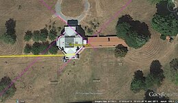
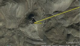
Hey, Reb. Here's something anyone can verify on Google Earth. Extend a straight line (great circle arc) from the south face of the Poplar Forest octagon westerly. See where it goes? Just a coincidence, I guess. Extend lines from other sides of the building NE, SE, and SE and see where they go. The Williamburg octagonal powder magazine NE and NW extensions are interesting too.

poplar forest.jpg
Poplar Forest


vp.jpg
Poplar Forest westerly extension
 

Rebel - KGC

Gold Member
Jun 15, 2007
21,680
14,739
Hey, Reb. Here's something anyone can verify on Google Earth. Extend a straight line (great circle arc) from the south face of the Poplar Forest octagon westerly. See where it goes? Just a coincidence, I guess. Extend lines from other sides of the building NE, SE, and SE and see where they go. The Williamburg octagonal powder magazine NE and NW extensions are interesting too.


View attachment 1259286
Poplar Forest


View attachment 1259287
Poplar Forest westerly extension
YEP! NICE!
 

Top Member Reactions

Users who are viewing this thread

Top