Two peaks

OP
OP
UncleMatt

UncleMatt

Bronze Member
Jul 14, 2012
2,389
2,530
Albuqerque, NM / Durango, CO
Detector(s) used
Garrett Infinium & Gold Bug II, Bazooka Super Prospector Sluice
Primary Interest:
All Treasure Hunting
By the way, if any of you need specialized GIS or mapping services, my friend can take care of everything for you in a jiffy, and then you pay him via PayPal on the GIS Co-op site where he is listed. I have made use of this guy for awhile now, and he is totally trustworthy in my opinion. If you want his contact info, please PM me. Please don't ask him about my projects with him, as he will laugh at you for doing so. Its also nice working with someone who is not in-country, and can't just drive or fly to the treasure sites in the US.
 

OP
OP
UncleMatt

UncleMatt

Bronze Member
Jul 14, 2012
2,389
2,530
Albuqerque, NM / Durango, CO
Detector(s) used
Garrett Infinium & Gold Bug II, Bazooka Super Prospector Sluice
Primary Interest:
All Treasure Hunting
Well, I was able to scan a print of the map, and then scan it as a pdf. But T-net will not allow pdfs for image file types!
 

OP
OP
UncleMatt

UncleMatt

Bronze Member
Jul 14, 2012
2,389
2,530
Albuqerque, NM / Durango, CO
Detector(s) used
Garrett Infinium & Gold Bug II, Bazooka Super Prospector Sluice
Primary Interest:
All Treasure Hunting
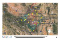
LAD Google Earth Map.jpg

Okay, here it is. Hope its not a let down to anyone. Sorry some of the distance sectors have colors that don't show up well against background map. That is why I need to figure out way to post the complete KMZ file...

Comments, suggestions, corrections? Be ready to defend your input.
 

OP
OP
UncleMatt

UncleMatt

Bronze Member
Jul 14, 2012
2,389
2,530
Albuqerque, NM / Durango, CO
Detector(s) used
Garrett Infinium & Gold Bug II, Bazooka Super Prospector Sluice
Primary Interest:
All Treasure Hunting
I almost forgot, there are additional landmarks pinned on this map, but they don't show up until you zoom in closer. Which you will be unable to do with this image. For example, D-Cross and Bell mountain are also on this map, just not viewable in this image.
 

OP
OP
UncleMatt

UncleMatt

Bronze Member
Jul 14, 2012
2,389
2,530
Albuqerque, NM / Durango, CO
Detector(s) used
Garrett Infinium & Gold Bug II, Bazooka Super Prospector Sluice
Primary Interest:
All Treasure Hunting
Can anyone enlighten me on the exact location of the Ojo Caliente Warm Springs Agency? Was it inside Monticello Canyon, or NW of it, or somewhere else? GPS would be great. Thanks.
 

OP
OP
UncleMatt

UncleMatt

Bronze Member
Jul 14, 2012
2,389
2,530
Albuqerque, NM / Durango, CO
Detector(s) used
Garrett Infinium & Gold Bug II, Bazooka Super Prospector Sluice
Primary Interest:
All Treasure Hunting
Highmountain (Purcell) gave the GPS as 33 34 9.27 N, 107 35 40.51 W in one of his posts here at T-net. But this is a hill at the north end of the canyon. On my map I have it farther to the NW, and wonder which is actually correct...
 

meister

Tenderfoot
Oct 4, 2008
7
3
Don't have lat/long, but several sources say that the agency headquarters were located near the Ojo Caliente spring. The spring is just west of the Monticello Box on the north side of the river. Highmountain is probably correct, would not be surprised if he was there before the ruins disappeared.
 

OP
OP
UncleMatt

UncleMatt

Bronze Member
Jul 14, 2012
2,389
2,530
Albuqerque, NM / Durango, CO
Detector(s) used
Garrett Infinium & Gold Bug II, Bazooka Super Prospector Sluice
Primary Interest:
All Treasure Hunting
Don't have lat/long, but several sources say that the agency headquarters were located near the Ojo Caliente spring. The spring is just west of the Monticello Box on the north side of the river. Highmountain is probably correct, would not be surprised if he was there before the ruins disappeared.

Actually, when I enter his coordinates, I get the hill at the mouth, on the south side of the canyon.

If anyone can provide GPS to a different spot, let me know please.
 

coco2

Newbie
Jan 28, 2010
3
1
Springerville, AZ
Primary Interest:
All Treasure Hunting
That's an interesting map, Uncle Matt - thanks for posting it. It'd be fun to be able to overlay the areas that meet the parameters of the descriptions (canyon walls, water, aspens, etc.) and see how many places there are to go poke around in. Probably enough to keep several of us out of mischief for a year or two!

I was remembering earlier a story that was circulating around here around 1996. There was a gold mining company office that had set up in Springerville, their story was that there was supposedly surface gold over just south of Red Hill (between Springerville and Quemado). They were setting up operations for that gold. An acquaintance of mine owned land right there, that ole boy was already making out his grocery list for when he got rich. But this was a real company/office...I had called them on a couple of occasions to check on employment for a friend of mine. I got sidetracked with other things and in the meantime that company disappeared and nothing ever came of it. Now I'm curious what the real story was on all of that, I'll have to ask around.

Nothing to do with the LAD, just something kind of interesting...
 

meister

Tenderfoot
Oct 4, 2008
7
3
UncleMatt,

Highmountain propably took GPS readings in the 90's. Selective availability wasn't turned off until 2000, that can cause a 100 meter error. The agency was supposed to be located across from where Ojo Caliente entered Alamosa Creek. By the way, what lat/long did you use?
 

OP
OP
UncleMatt

UncleMatt

Bronze Member
Jul 14, 2012
2,389
2,530
Albuqerque, NM / Durango, CO
Detector(s) used
Garrett Infinium & Gold Bug II, Bazooka Super Prospector Sluice
Primary Interest:
All Treasure Hunting
OP
OP
UncleMatt

UncleMatt

Bronze Member
Jul 14, 2012
2,389
2,530
Albuqerque, NM / Durango, CO
Detector(s) used
Garrett Infinium & Gold Bug II, Bazooka Super Prospector Sluice
Primary Interest:
All Treasure Hunting
I will check on that lead about that mining company. I am also working with my GIS specialist in Albania to get my GE map up and running. May take awhile though. I think it will be an interesting experiment to show all the available factors on a map so that everything can be seen at a glance.


That's an interesting map, Uncle Matt - thanks for posting it. It'd be fun to be able to overlay the areas that meet the parameters of the descriptions (canyon walls, water, aspens, etc.) and see how many places there are to go poke around in. Probably enough to keep several of us out of mischief for a year or two!

I was remembering earlier a story that was circulating around here around 1996. There was a gold mining company office that had set up in Springerville, their story was that there was supposedly surface gold over just south of Red Hill (between Springerville and Quemado). They were setting up operations for that gold. An acquaintance of mine owned land right there, that ole boy was already making out his grocery list for when he got rich. But this was a real company/office...I had called them on a couple of occasions to check on employment for a friend of mine. I got sidetracked with other things and in the meantime that company disappeared and nothing ever came of it. Now I'm curious what the real story was on all of that, I'll have to ask around.

Nothing to do with the LAD, just something kind of interesting...
 

OP
OP
UncleMatt

UncleMatt

Bronze Member
Jul 14, 2012
2,389
2,530
Albuqerque, NM / Durango, CO
Detector(s) used
Garrett Infinium & Gold Bug II, Bazooka Super Prospector Sluice
Primary Interest:
All Treasure Hunting
Over a month now since anyone has posted anything about the LAD. I wonder if this story is simply no longer viable for many people to do further research on. Maybe its all already been said...
 

Oroblanco

Gold Member
Jan 21, 2005
7,838
9,830
DAKOTA TERRITORY
Detector(s) used
Tesoro Lobo Supertraq, (95%) Garrett Scorpion (5%)
Over a month now since anyone has posted anything about the LAD. I wonder if this story is simply no longer viable for many people to do further research on. Maybe its all already been said...

UncleMatt - have to respectfully disagree that the story is no longer viable, there is definitely still strong interest in the Lost Adams. Several people have claimed to have found it, but show NO gold which makes the claim hard to swallow. Part of the problem (as is common for several of the famous or popular lost mines) is in the amount of pure BS that has gotten mixed in to the original story. Sorting it out can be tough at times.

Good luck and good hunting Uncle Matt and anyone reading this, I hope you find the treasures that you seek.
Oroblanco
 

OP
OP
UncleMatt

UncleMatt

Bronze Member
Jul 14, 2012
2,389
2,530
Albuqerque, NM / Durango, CO
Detector(s) used
Garrett Infinium & Gold Bug II, Bazooka Super Prospector Sluice
Primary Interest:
All Treasure Hunting
I agree Oro, the BS flies very thick when it comes to the LAD. It just seems to me that people are more and more unwilling to discuss any new info on it out in the open.
 

Mar 2, 2013
729
1,825
Primary Interest:
All Treasure Hunting
UM

I have been enchanted and captivated by the mystery surrounding the legend of the LAD.

After reading the standard version of Adams & co visiting the canyon, Apaches, , massacre, pot of gold, attempts to rediscover the site etc., I made attempts to collate and try and document everything in an orderly fashion and with clear timelines. I purchased all the usual books and tried to disseminate the truth from the hyperbole. I contacted various authors for their views on discrepencies I encountered. After about two years of doing so, all I can say is that there was an incident in the Southwest of the States about 150 years ago involving various characters including the infamous Adams and a certain amount of gold. In a lonely place some folk lost their lives; gold was found and then lost - buried, stolen or otherwise - then many people made serious attempts to locate it. Was it found and surreptitiously taken out??
Hmmm...that's what nobody can conclusively say.

But to spend resources and efforts on a literal translation and belief of the standard story is not advised, as has been said it will be extremely difficult to separate fact from fiction all these years after the event. Looking at maps and attempting to decipher possible locations and directions, is doomed to frustrate in my humble opinion. This is because it would mean accepting the version as espoused by Adams himself for what to look out for when seeking that fabled canyon. I cannot accept that this chap told the truth and was sincere in what he led people to believe had happened. Then Dobie wrote his commendable book and that sometimes suggested things without discussing sources or references.

If my time looking into this super story told me anything, then I would say: 'Why did Adams spend his later years looking for the buried pot of gold as oppose to the amazing location that was alleged to have been one huge open gold mine with another location nearby with the "Two Peaks"?
There is probably a small telling sign in there somewhere I would say.:dontknow:


IPUK
 

OP
OP
UncleMatt

UncleMatt

Bronze Member
Jul 14, 2012
2,389
2,530
Albuqerque, NM / Durango, CO
Detector(s) used
Garrett Infinium & Gold Bug II, Bazooka Super Prospector Sluice
Primary Interest:
All Treasure Hunting
Thanks for posting IPUK, but I am not aware of any sources that state he was only looking for a "buried pot of gold" in his search for the LAD when he returned.
 

Top Member Reactions

Users who are viewing this thread

Top