Undersea Gold Mining!

Oceanscience

Full Member
May 23, 2010
207
201
Just start by staking your first claim.
What do you need for that? There are legal requirements. What are they?
How many different samples do you need?
We know the gold is there, but we need to know we can get at it.

A sub-bottom profiler might give some very useful information.

Try to get an educated guess from a local geologist.

Perseverance will get you there!!!!!!!!!!!!!!!!

PS. I PM'd you with special information
 

aquanut

Bronze Member
Jul 12, 2005
2,162
1,578
Sebastian, Florida
Detector(s) used
Fisher CZ21, Tesoro Tiger Shark
That was truly an interesting report Oceanscience. Lucky Eddie, keep pushing, it looks like you might be getting somewhere with this.
aquanut
 

OP
OP
L

Lucky Eddie

Sr. Member
Feb 9, 2010
358
187
My second lad is a lot more computer literate than me - so I will see if he can register with the mines dept computerized ten-graph system and we will look and see what areas if any are available for lease and whats involved in staking a claim.

Can't hurt to do a little research can it?

Cheers
 

chappysgold

Tenderfoot
Mar 15, 2009
6
1
adelaide
Detector(s) used
GPX4000,SD2200
Nothing wrong with your theory mate.
There might be a few other obstacles though,besides what you mentioned.
The lease around balla balla creek and further is E47/1625 and still pending since 2005 ??? ???
it is held by the one and only BHP Billiton minerals >:( >:(.

Further inland we have murambarinya community this area is all crown reserve as is Depuch island.
Native title in this area would be a bit of a nightmare. Because its considered a sacred place by the Ngaluma
people.Actually curious to do you have any info on anchor and wreck point,what wrecked there.

Now between muambarinya and whim creek we have another large lease held by MT Stewart Resources,
this a granted exploration lease.

Around whim creek and out towards Loudens and Toweranna are mostly smaller mining and prospecting
leases so puts them out of bounds.These are known good alluvial areas.

Now the good news is you can go on the BHP lease as you are allowed to prospect on a pending exploration lease.
With MT Stewarts you can take out a 20A which will allow you to access their lease and do some prospecting.
Taking out a 20A is pretty cheap but keeps you legal.You will need a miners right too 25bucks by memory.

Now with creeks, beds and banks apply this is put in place to prevent disturbing them.Suction dredging is not allowed,
so its something that will have to be checked.

If you have a hassle with tennagragh eddie drop me a line it can be a bugger until you get used to it.
A lot of things i never mentioned,if i can help yell

cheers mate.....chappy
 

OP
OP
L

Lucky Eddie

Sr. Member
Feb 9, 2010
358
187
Hey Chappie,

What you post is right - you might have omitted Aurox resources new magnetite holding all over the balla balla flats.

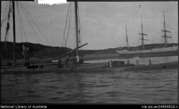
Yes I do have info on the wreck - its likely either the concordia or cleo if you can believe the records, sunk in a cyclone in I think 1912 from memory along with another timber vessel that hit the beach and was later refloated - brought to fremantle and used as a coal barge.

http://nla.gov.au/nla.pic-an24668620

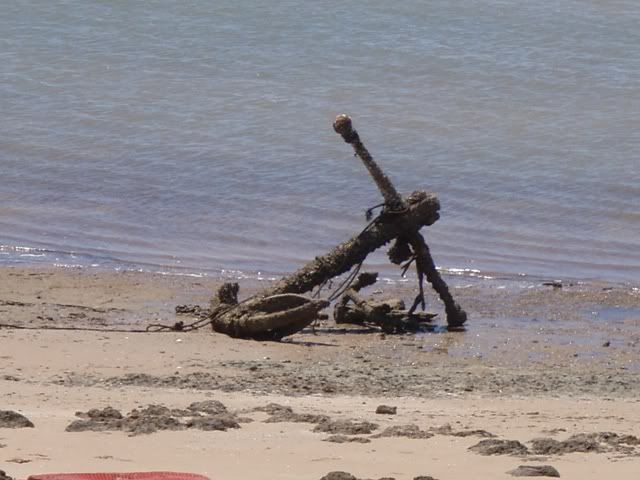
The large anchor at West Moore apparently came from that wreck or the eddiestone - not sure which and was floated there on air bags bye the pearl divers back when it was a operational Pearl Farm up till 1999 when hit by cyclone John.

From W.A. Maritime Museum.
Eddystone. Iron steamer, 2040 tons. Built 1886. Lbd 275 x 36 x 20 ft. Struck a reef at Depuch Island, about 50 km from Cossack, WA, 8 September 1894.The engine room and forehold filled rapidly and as the vessel lay partly submerged, three pumps and diving gear were sent to the wreck, however before they arrived the steamer floated free but the tide swept her back on to the reef again about two hundred metres away. She was auctioned as is and dismantled. [LW],[DG]

We did a brief and I mean brief dive on the steel hulled wreck at wreck point about 2 years ago an all steel vessel - many large frames etc still in situ - covered in fish - but man the ol tide fairly rips thru there, and we never managed to be there at say the hour leading up to and just after the turn of the tide on a neaps - to be able to dive it properly. Always seemed to have work to do!

DePuchIslandwrecks-1.jpg


Thats a national library photo of the two vessels...

Image166.jpg


Stern quarter above water at wreck point.

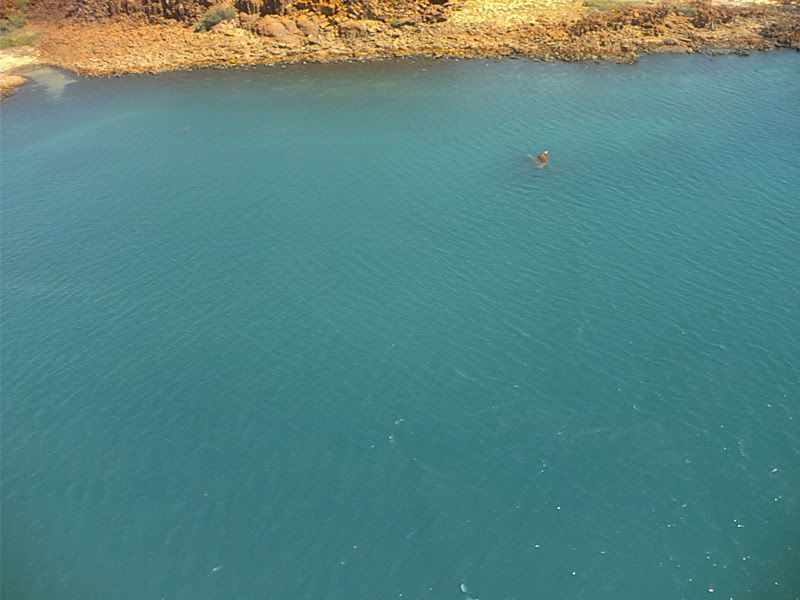
Theres another old wreck gets exposed on low tides halfway between wreck point and Rosemary Island as well probably went down in the same cyclone (I think a total of 4 all told in the 1912 cyclone).

With regards too the leases Chappie - yeah I know about DePuch being an cultural heritage listing etc, I'm not interested so much in existing leases on land,

I WOULD be interested in a leasewithin the estuary - water area of Balla balla and also the ocean from Estuary mouth out to sea to the continental shelf maybe 40 or more miles out as long as the old river bed is included.

Were the leases you were referring too included in those ocean areas or are you looking at the land leases already pegged up there?

Just curious - will probably need that help with tengraph, I am sure of it.

Ohh...

Back to diving...

Remember me saying that there was an operational Pearl Farm lease at West Moore back in 1999 when cyclone John hit? One of our jobs was to re establish the pearl farm and resurrect the pearl lines - and get new shell from the hatchery back into the lease etc which we did.

ONE of the jobs among many - was diving to locate all the sea anchor pins embedded into the flat coral bottom within the lease too which the new long pearl lines needed to be attached.

While doing that my lad happened to locate a few old pearl panels that had been sunk / dislodged off the original pearl lines 10 years before in 1999 and laid sort of half buried in the mud for the last 10 years.

Some of the panels had even disintegrated and there were just the living pearl shell now attached too the bottom.

He bought up, with one of the directors, 10 large live shell.

It seems that these shell had been seeded for a year or so before the cyclone, and were due for harvest in another year or so's time when lost in the cyclone in 1999.

So rather than get harvested - they sat there for about 10 years just growing bigger n bigger pearls every year until found.

Out of the 10 live shell - the Dorector obtained 3 large pearls bout the size of the end of your thumb - absolute beauts - no farms normally leavethem so long to get so big.

Director gave one too my wife as a memento of our son finding it, and we had it set as a necklace - everyone comments on it you just don;t see such big pearls often - the commercial farming system tends not to keep shell in the water for that length of time.

Well once the 3 big pearls came up that was the end of the diving for the 2 lads - the director spent the next 2 weeks diving ALONE every day for 5 or 6 hours searching for more live shell, never actually said what he was doing in the lease (but its not hard to figure out - he was down there slitting open shell as fast as he could go and stuffing big fat pearls into his wetsuit) and the lads weren't allowed anywhere near the lease after than when diving.

Anyway - the thing is, no one knows too this day whether he told the rest of the board of directors about the pearl finds and whether any of them got a cut - I sincerely doubt it myself - reckon he knocked off the lot for himself - even the company owner probably never saw one I'm guessing.

Anyway they are the companys lease and the companys shell and personally I dont give a round rats touch what they do with their shell or pearls or if they cheat each other as a matter of routine, nothing would surprise me.

Why mention it then?

Well the whole farm was wiped out in the 1999 cyclon John which scored a direct hit and was a cat 5, so all of the pearl lines were ripped from their pins etc an LOTS of panels clipped onto the lines were set adrift with the pearl floats still attached so they would have spread far and wide I reckon - we had reports of pearl floats buried in the sand up north past Rosemary island from locals who saw them when out fishing.

When diving - if you could find any of the missing panels on the bottom outside of the pearl lease....well theres a damn good chance that a LOT more 10 year + cultured pearl is just sitting there for the picking - however - the Fisheries laws about taking wild shell or even cultured shell if your not a pearl license holder etc are pretty steep so you sure wouldn't want to get caught doing it....but trust me they are huge mutha's of pearls - not all are 100% obviously laying in the bottoms not an ideal incubation site for unblemished pearl which is why the farmers hang them suspended from the pearl long lines suspended from pearl floats along the line to bear the weight of the panel to keep them clear of the mud.

Thing is IF you know they might be down there it can't hurt to keep you eyes open i guess. :laughing7:

Find some gold - find a nice pearl - might keep you in brownie points with "she who must be obeyed" for ages - who knows.

Back to Depuch Isl..

You US shipwreck hunters will LOVE this link in its entirelty if you have the time to read historical ships logs from the 19th century

http://www.gutenberg.org/files/12146/12146-h/12146-h.htm

I'm just quoting the part about there visit to that big volcanic De Puch island in the photos is all!

PROCEED TO THE COAST.

The part of the North-west coast that had not been seen by Captain King, commencing a short distance to the east of Depuch Island, it was resolved that our survey of that part should begin there, and on the 9th of June the Beagle reached an anchorage off a sandy bay on the north-east side of that island. As we drew near our progress was impeded by a fierce south-east breeze during the forenoons, which we found to prevail during our stay, being stronger at the full and change of the moon. Although coming directly from the land they quite made us shiver, reducing the temperature on one occasion to 59 degrees. These winds began about daylight at south, gradually veering and drawing round to the eastward as the day advanced, and subsiding again as rapidly after noon, leaving the evening and night generally calm.

SEARCH FOR WATER.

A search was immediately made for the stream of fresh water reported to have been found by the French, in Freycinet's voyage, on Depuch Island. As our stock was now very much reduced, and as our stay on the coast depended on the supply we could procure here, we were greatly concerned to find that our examination was in vain. Everything appeared parched up; wells were forthwith commenced, and we dug as many as eight, but at the depth of twenty-one feet the water that poured into them was salt. Fortunately Mr. Bynoe found a reservoir of water in the main valley leading up from the north end of the sandy beach, and about a mile from the sea. From this we got about six tons of tolerable water, although the labour of carrying it on the men's shoulders in seven-gallon barecas was very great, the only road lying through the valley, which, as may be inferred from the rounded stones it is strewed with, sometimes conveys a torrent to the sea. Large columnar blocks of the greenstone of which the island is composed, present, as the sun falls on their iron rusty surface, an appearance as if the sides of the valley were lined with red warriors. The section presented to our view, by the deepest well we sank at the mouth of this valley, consisted of a light kind of mould for six feet, then a layer of sand and shells of the same depth, resting on a coarse soft kind of reddish sandstone.

FORESTIER GROUP.

Depuch is the centre of a string of islands which bears the name of Forestier Group, fronting the coast at the distance of from one to three miles. It is much larger than the others, being about eight miles in circumference, and reaching an elevation of 514 feet; whereas the smaller islands, some of which are thickly covered with brushwood and coarse grass, are none of them above 50 feet high. They are of a formation totally different, being of a very coarse gritty yellow sandstone, in many places quite honeycombed, with some low sandhills superimposed.

DEPUCH ISLAND.

Although Depuch Island is one vast pile of reddish-coloured blocks, scattered about in the greatest possible confusion, sometimes resembling basaltic columns, its outline from seaward appears even. In the valleys, and on some of the more level spots near the summit, there are occasionally slight layers of soil, affording nourishment to a coarse grass, a few bushes, and several stunted eucalypti; but on the whole the vegetation of the island is extremely scanty. From the highest point we had a view over the main, extending inland for a great distance. It appeared to be flat, with the exception of some isolated rocky hills, of a formation similar to that of Depuch, from 200 to 500 feet in height, and about six miles from the shore. We could also see at a distance of twenty-eight miles a very remarkable pyramidal hill, surmounted by a tower-like piece of rock, bearing from our position South 30 degrees West. From the white appearance of many large patches of the level country, we inferred that they were covered with a salt efflorescence; and it is probable that a very great portion of it is occasionally flooded, being cut up by a number of creeks, which must overflow at spring tides, especially when they occur simultaneously with the north-west winds that prevail on this coast during the monsoon.

This group of islands is so connected with the main by extensive sandbanks, that at low-water it is possible to walk across to them; and of this facility the natives no doubt avail themselves to procure turtle. It appears indeed to be only on such occasions that they can visit Forestier Group, as we saw no traces of rafts on this portion of the coast. Depuch Island would seem to be their favourite resort; and we found several of their huts still standing. They were constructed of boughs and twigs fixed in the ground, and joined overhead in a circular shape. Over this was thrown a loose matting of twisted grass.

NATIVE DRAWINGS.

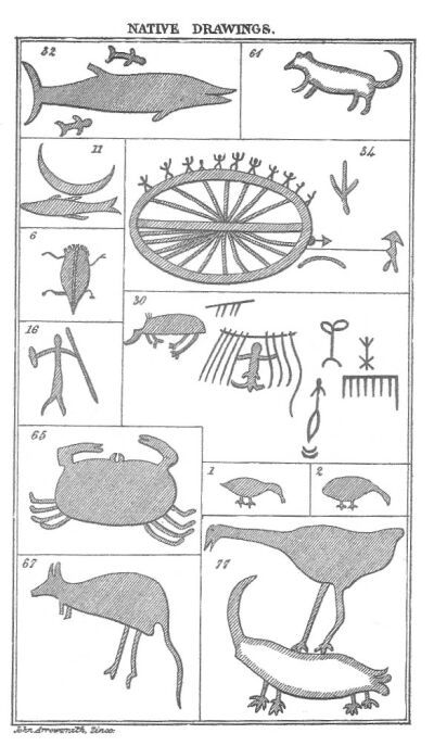
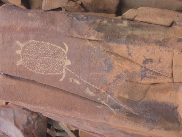
The natives are doubtless attracted to the place partly by the reservoirs of water they find among the rocks after rain, partly that they may enjoy the pleasure of delineating the various objects that attract their attention, on the smooth surface of the rocks. This they do by removing the hard red outer coating, and baring to view the natural colour of the greenstone, according to the outline they have traced. Much ability is displayed in many of these representations, the subjects of which could be discovered at a glance. The number of specimens was immense, so that the natives must have been in the habit of amusing themselves in this innocent manner for a long period of time. I could not help reflecting, as I examined with interest the various objects represented*--the human figures, the animals, the birds, the weapons, the domestic implements, the scenes of savage life--on the curious frame of mind that could induce these uncultivated people to repair, perhaps at stated seasons of the year, to this lonely picture gallery, surrounded by the ocean-wave, to admire and add to the productions of their forefathers. No doubt they expended on their works of art as much patience and labour and enthusiasm as ever was exhibited by a Raphael or a Michael Angelo in adorning the walls of St. Peter or the Vatican; and perhaps the admiration and applause of their fellow countrymen imparted as much pleasure to their minds as the patronage of popes and princes, and the laudation of the civilized world, to the great masters of Italy. There is in the human mind an irresistible tendency to indulge in a sort of minor creation--to tread humbly in the footsteps of the Maker--to reproduce the images that revolve within it, and to form, from its own ideas, a mimic representation of the actual world. This is the source of all art and all poetry; of every thing, in fact, which tends to adorn and refine our nature. It is this uncontrollable desire to work on and fashion the rough materials that lie under our hands that gives the first impulse to civilization, and impels us onward in the progress of improvement. And wherever we discern the faintest indication that such a principle is at work, there we may securely hope that development will ultimately take place. Until we find a nation which has never attempted to emerge from the circle of its mere animal wants--which has never exhibited the least inclination to develop the most ordinary arts--which not only rejects clothing, but is absolutely indifferent to ornament--which leaves its weapons uncarved, its skin unpainted, free from tattoo, we must not despair of the general efficacy of civilization. These savages of Australia, as we call them, who have adorned the rocks of Depuch Island with their drawings, have in one thing proved themselves superior to the Egyptian and the Etruscan, whose works have elicited so much admiration and afforded food to so many speculations--namely, there is not in them to be observed the slightest trace of indecency.

(*Footnote. See the accompanying lithographic impression of the copies made by Captain Wickham of the native drawings on Depuch Island.)
stokes2-11.jpg

NATIVE DRAWINGS.

Lithographic impression of the copies made by Captain Wickham of the native drawings on Depuch Island. They have already appeared in the Royal Geographical Journal Volume 12. The following list will convey to the reader what the drawings are intended to represent.
1. A goose or duck.
2. A bird; probably the leipoa.
6. A beetle.
11. A fish over a quarter-moon; which has been considered to have some reference to fishing by moonlight.
61. A native dog.
16. A native, armed with spear and wommera, or throwing stick, probably relating his adventures, which is usually done by song, and accompanied with great action and flourishing of weapons, particularly when boasting of his prowess.
20. A duck and a gull.
34. A corrobory, or native dance.
65. A crab.
30. A native in a hut, with portion of the matting with which they cover their habitations.
67. A kangaroo.
71. Appears to be a bird of prey, having seized upon a kangaroo-rat.
32. Shark and pilot-fish.

During our stay we did not see any of the natives on the island; but on the main several of them were observed, though they would not allow us to communicate, moving off as soon as any attempt was made to get near them in the boats. On one occasion, when Mr. Fitzmaurice, in a whaleboat, was examining a part of the coast to the eastward of Depuch Island, he entered a creek, which soon, however, became too confined by the mud-banks for them to use the oars.

HOSTILITY OP THE NATIVES.

While in this position a shout attracted his attention, and he perceived a party of natives, armed with spears approaching the boat, with evident hostile designs. They of course naturally looked upon us as intruders; and as the point was not worth contesting, the creek being of no importance, Mr. Fitzmaurice thought it better to withdraw, rather than run the risk of a collision that could have led to no beneficial results.

TOM'S TERROR OF THEM.

The native youth we had brought with us from Swan River did not at all approve of these excursions. He was generally taken, with a view of giving confidence to any of his wild countrymen who might be encountered; but he exhibited the greatest possible repugnance to this service. His terror for the northern men fully equalled that of Miago, from whom doubtless he had received the most terrific accounts. It was only by giving him a gun that he could be at all induced to go. He evidently felt himself more secure with European arms than with his own rude ones; and appeared to have learnt their superiority by experience, for he was a very fair shot. When I first asked him why he did not prefer his spear, his simple reply was, "Can't look out;" meaning that the northern men could not see the contents of a gun coming, whereas if a spear were hurled at them they could avoid it. His bravery was of much the same complexion as that of Miago; and he threatened magnanimously to inflict the most condign punishment on the fellows who opposed Mr. Fitzmaurice's landing. He had a strong impression that these northern people were of gigantic stature; and in the midst of the silent and gaping interest with which he listened to Mr. Fitzmaurice's account of his adventure, the words big fella often escaped from his lips; and he appeared quite satisfied when assured that his opinion was correct.

The agility this native exhibited in spearing fish was astonishing. In shallow water he would actually course the fish till he got them within spearing depth, when, although his prey darted past, he struck it with the most surprising precision. The quiet, splashless manner in which he ran through the water was really singular. When his spear required new pointing, the sole of his foot was turned up and the spear's head pared down upon it with a knife. When the latter was not to be procured the teeth were made use of; and I may here remark that the constant use which some savages make of their teeth may have much to do in producing the projecting jaw. It seems almost evident to common sense that the constant employment of the teeth must have a material effect in causing a change in the facial angle.

ANCHORAGE AT DEPUCH ISLAND.

We found the anchorage at Depuch Island to form a tolerable port, being protected from the north-east by one of the group, distant about three miles, from which a reef extends to the West-North-West, leaving the mouth of the harbour exposed only between North-West by North and West-North-West. Our observations placed the centre of the sandy beach on the north-east side of the island in latitude 20 degrees 37 minutes 47 seconds South and longitude 2 degrees 0 minutes 20 seconds West of Swan River, variation 2 degrees westerly; and the time of high-water, at the full and change, at half past ten, when the tide rose 15 feet, but only 5 during neaps.

NEW BIRD AND KANGAROO.

Although Depuch Island had been visited before, there still remained something quite new to reward the diligent search that was made after objects of natural history: namely, a small kind of kangaroo, a land bird, and a shell, a species of Helix. The bird was shot by Mr. Bynoe; it was a finch,* and beautifully marked with stripes of crimson down the breast, on a black ground with white spots; the throat, and a patch round the stump of the tail, were crimson. It is remarkable that all the beauty and brilliancy of colour in this bird is underneath, the back being of a common earthy brown.

(*Footnote. Named by Mr. Gould from this specimen, Emblema picta.)

The kangaroo I had myself the good fortune to knock over on the summit of the island; it was the only one shot during many an excursion made over that dreary heap of desolation, the metallic sound the rocks yielded to our step giving ample warning of our approach to their quick ears. The colours of this specimen, the prettiest we had seen, were a dark grey, with a large angular patch of white down the side, extending from the top of the shoulders nearly to the hips. Down the centre of the back, ran a streak of black, which was also the colour of the extremity of its slightly bushy tail. The face and belly were likewise darker than other parts of the body, and the feet were black and well cushioned, giving it a firm hold of the rocks over which it bounded with surprising agility, through it never ran very far, always popping into the cavities caused by the loose manner in which the blocks forming the island are thrown together.*

(*Footnote. Mr. Gould has figured an animal very like this I have described, as Petrogale lateralis, or the Stripe-Sided Rock Wallaby, from a specimen he some time afterwards got from Western Australia; but he has not noticed the beautiful kangaroo of Depuch Island.)

The specimen of the species of Helix I have above mentioned was found by Mr. Dring, one of our most successful collectors in that department. In the Appendix are figured some of the new shells discovered during the voyage.

Leaving Depuch Island, we examined the coast to the eastward as far as the Turtle Isles, a distance of eighty-five miles, the first twenty-seven of which trended North 55 degrees East, and the remainder North 67 degrees East curving slightly inwards. As the French had obtained a distant view of this coast, it did not possess to us the interest of being a new portion of the continent.

EFFECTS OF MIRAGE.

Still the effect of the treacherous mirage, which has often deluded the way-worn thirsty traveller with the false appearance of water, raised many parts of the interior that had not before met the eye of an European. These presented a very level outline. The interior was, for a great distance, a vast plain, so low that we could scarcely see it from the ship's masthead over the sandhills, which did not exceed the height of 40 feet. Six or seven miles from the Turtle Isles this extensive level was interrupted by the presence of a group of hills, from 200 to 300 feet in elevation, apparently of the same character as the heights behind Depuch Island. As seen through the medium of mirage, they often had a most curious appearance: high continuous ranges, changing again to lofty islands, danced in the tremulous air. I should remark that when the land was subject to this distortion, it was always during the forenoon, and on those days the winds were invariably light.

APPEARANCE OF THE COAST.

The shore, for nearly fifteen miles from Depuch Island is very low, lined with mangroves, and intersected by creeks, which at high-water, when the tide rises sometimes 18 feet, are of some magnitude, and inundate much of the low land, leaving large portions of it whitened by a salt incrustation. Beyond, as far as the Turtle Isles, the coast is fronted with a ridge of sandhills, scantily covered with vegetation (the highest, as I have already said, rarely exceeding an elevation of 40 feet) forming a barrier between the sea and the low lands behind, which, from the masthead, appeared to be thickly covered with small trees, and slightly raised from three to seven miles from the coast. Several of the natives showed themselves at a distance, and from the numerous fires, it appeared to be a well inhabited part of the continent. Still we saw no appearance of a stream of fresh water; and, though there were several creeks, the only opening of any consequence was forty-three miles from Depuch Island. From its abounding with oysters we named it Oyster Inlet. Across the mouth of it lies an islet, just within the north-eastern end of which there was a sufficient depth for the Beagle. The formation of the island was a reddish porous sandstone. At a native fire-place I found a piece of quartz and a large pearl oyster-shell. The tide rose here 15 feet near full moon.

THE GEOGRAPHE SHOALS.

The only outlying dangers on this extent of coast were the Geographe Shoals, two rocky patches some distance from each other. The outer one was thirteen miles from the main, and bore North 22 degrees East twenty-three miles from Depuch Island.

Its like actually being on board of you read the whole entry at the link for the voyages - I heartily recommend it.

Its of tpic about gold mining I know - but your guys are into shipwrecks and this is the forum for it so i figured what the heck I'll add some rad guts to the thread for anyone was getting bored.

Hope this fills in some gaps for you Chappie - any chance you'd come round to Morley and show me this tengraph thing and how it works?... Might be a few ales in it for you if your keen?

Heres that anchor for you!

EddiestoneAdmiraltyAnchors.jpg


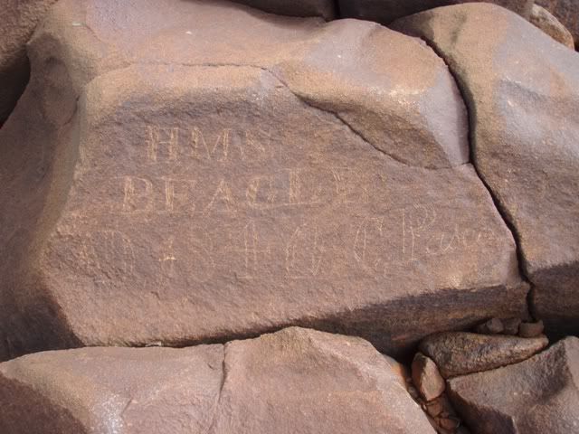
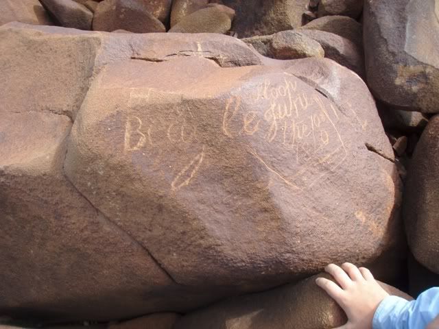
Beagle inscriptions from 1840
Beagel1Inscription.jpg


Beagle2.jpg


and some of the native ones

OriginalFlyCaster.jpg


Lots too see n do around that area -I reckon the guys on here would come home with some amazing and unique photos - few of us white fellas have walked over that island in any great detail.

Cheers
 

chappysgold

Tenderfoot
Mar 15, 2009
6
1
adelaide
Detector(s) used
GPX4000,SD2200
Yep its the lucky country allright.Top yarn,bit hard to get to morley at the
moment fly in/out of kal from east at present but will take a rain check on the coldie.
From memory the leases stop about 3 miles offshore,hard to check as tengraph is off line at the moment.

Its sort of a new type of idea for oz, being offshore mineral proccessing.Cant see why it cant be done
if the goods are there.Might have to warm up the grey matter.
All types of thoughts come up especially the top end (diamonds) i wonder if de beers have looked
into it out side of south africa.


Great pics and information for the memory bank.
Cheers mate....chappy
 

OP
OP
L

Lucky Eddie

Sr. Member
Feb 9, 2010
358
187
From what I know there's already been perhaps 2 attempts to mine diamonds in the cambridge gulf (ord river outfall).

http://www.abc.net.au/rural/wa/stories/s1412809.htm

Sucking diamonds from the sea - Bronwyn Herbert
Let's make our way around to the Kimberley coast line now where an interesting exploration project is about to take place. Later this month the sea floor off the Cambridge Gulf will be searched for diamonds. There was an attempt to find the marine gems in the early 1990s, but that failed. Mike Woodbourne from Bonaparte Diamonds says the company plans to pick up where those explorations left off.
He told the Country Hour, he's confident the diamonds will be found. The ship's equipment is designed for the strong tidal conditions synonymous with the Cambridge Gulf. Mr Woodbourne, says gems will be sucked from the sea floor using what he describes as an, "underwater vacuum cleaner." He says they can control it quite precisely, and the thin sediments are sucked up to the surface using an air-lift method, similar to expanding bubbles in scuba diving equipment. Bonaparte Diamonds will begin exploration later this month. Alluvial diamonds are typically dragged from their original rock structure, down ancient rivers and left as sediments on the sea floor. According to geologist wisdom, the alluvial process knocks out rough diamonds, so there's a high chance of scoring flawless gems in alluvial finds, and hopefully, the associated price!
Mike Woodbourne, chief executive and geologist, Bonaparte Diamonds.

and this:

http://www.csmonitor.com/1994/0202/02072.html

February 2, 1994

SYDNEY

THERE is a recovery going on in the world's industrial diamond markets, and Australia is leading the way.

After a prolonged slump, reflecting worldwide recession, diamonds for industrial use are expected to be a major beneficiary of economic recovery in Europe, more vigorous United States expansion, and rapid growth in the rapidly growing economies of the Asia Pacific region.

Australia produces 40 percent of the world's diamonds, most of them industrial cutting diamonds. A high proportion come from Argyle Diamonds, the largest diamond mine in the world, in terms of carats. Argyle, owned by CRA Ltd., had a record production year in 1993 of 41 million carats.

``CRA and Ashton [Mining Ltd.] both produced significant volumes of diamonds in a recovering world market,'' says David Walker, senior mining analyst with CS First Boston, a brokerage house in Melbourne.

``With industrial production worldwide rising for cutting and machine tooling, you need industrial diamonds,'' says David Galloway, research manager at the brokerage firm McKinley Wilson. ``They have been depressed because of recession for many years.

``But they should be turning around quickly in the next year or two. Gem-quality diamonds will go up too. They're coming along.''

DIAMOND production here is forecast to reach a record 43 million carats in 1993-94. Export earnings from diamonds are forecast to increase 20 percent in 1993-94, to around $600 million (Australian;US$426 million), according to the Australian Bureau of Agriculture Resource Economics.

High production and the easing of the Central Selling Organization's purchasing quota put in place last July are expected to increase export volume. The CSO is the world body that contracts with producers to sell diamonds.

``The diamond market is firmly in recovery and we're optimistic that CSO [purchasing quotas] will be relaxed or removed in 1994,'' Mr. Walker says.

With the exception of South America and Australia, diamond production at major diamond-producing centers was down or flat compared with 1991.

Production is down in Angola because of fighting. And in the Commonwealth of Independent States, production declined 13 percent to an estimated 13 million carats in 1992-93 because of political and economic reform disruptions.

At the same time that business is picking up for its major mines, Australia is undergoing something of a diamond ``rush.'' The last two years have seen a significant number of diamond finds, mainly in the Kimberly region in the northern part of Western Australia. Prospecting is going on both on land and in the sea, where rivers in diamond-producing areas converge.

``There's a fair bit of excitement there at the moment,'' says Stephen Gerhardy, an economist with the Chamber of Mines and Energy in Perth. ``A number of discoveries are still to be assessed in terms of their commercial value.''

Cambridge Gulf, the only company doing marine alluvial mining, found 23 rough-cut diamonds of gem quality with a combined weight of 5.87 carats in December. The company's stock shot up $2 a share after the announcement but has since simmered down.

``The Cambridge concept is exciting, but there are a lot of technical difficulties to be overcome before those projects move to production,'' Walker says.

Anton Gans is a mining engineer with Cambridge Gulf who pioneered marine alluvial mining in South Africa in the 1960s.

``It's encouraging that we found submerged gravel, that they are of terrestrial origin, and that they contained some diamonds,'' he says. ``That doesn't mean there is a mine out there yet. We have a long way to go.

``In South Africa, it was brand new and nobody believed you,'' Mr. Gans says. ``Now in South Africa, on the weekends they go out in wetsuits and find diamonds offshore.''

``In Australia it's the same situation as 35 years ago - people haven't heard of it,'' Walker adds.

With all that said - it appears that Cambridge Gulf hit a few 'snags' in yr 2000

The following makes especially interesting reading:-

http://www.asic.gov.au/asic/pdflib.nsf/LookupByFileName/00-167.pdf/$file/00-167.pdf

Also very interesting reading is page 11 of this link from 2006

http://www.aig.asn.au/pdf/AIGNews_Mar06_revised.pdf

You can see that way back in 1994 someone was getting the big miners "interested".......

http://www.diamonds.net/News/NewsItem.aspx?ArticleID=785

It seems like lots of speculative dollars were being sought by some questionable sampling methods maybe?

http://www.metallurgy.com.au/metall...ridge-consultant-slated-for-breach-of-ethics/

There's patently a lot of diamond available to be found / mined in the Kimberley - no question about that, but world powers don't stand idly bye while Joe Amateur makes significant discoveries of that sort of magnitude of wealth, this is the stuff of covert industrial espionage, in order for ownership of the company's to change hands and names several times, as agents of various nations & corporations clandestine services, make damn sure that Joe Amateur gets a few shekels to piss off or winds up dead in a dumpster of he refuses 'the offer too good too refuse' put to him, to "sell" his interest and let the nation / multinational corporation take over the ownership they want.

It could well even be - the main De Beers competitor in Argyle Diamonds that's behind making sure no NEW deposits, marine or otherwise get started up while their currently profitable mine is operating.

One need only read about ho John D Rockerfeller took over all Texas and then eventually US and later world Oil supplies with his Union tanker company sleight of hand ruse.

It's at least "useful" to know what on ill eventually be up against if one starts down this mining trail and has any overt success.

These links kind of show what will most likely eventuate.

http://www.brojon.org/frontpage/bj050701-1.html

http://www.brojon.org/frontpage/bj050701-2.html

http://www.brojon.org/frontpage/bj050701-3.html

http://www.brojon.org/frontpage/bj050701-4.html

It's always handy to know who ones future enemy's are likely to be when you embark down these pathways.

Maybe the company now fighting Spain for the rights to shipwreck gold coins etc wold do well to find out who it REALLY is that they are up against - who is it that has decided to usurp their finds and treasure - who really is the Soros type parasite that sits back and takes no risks, invests no exploration capital, but hopes to usurp every one else's hard won profits thru chickanery and other illegal methods.

There are a LOt of individuals these days who are just corporate highway men, they wait until your transporting the results of your hard won treasures - and make you stand and deliver at the pointy end of a legal barrel!

Look at it this way - there's the old joke about the lawyer shipwrecked and every other passenger gets eaten by the sharks because - the sharks won't bite the lawyer out of professional courtesy!

Well crooked lawyers go on too become crooked judges, and they keep their crooked money in crooked banks...and they use it too buy crooked politicians and crooked accountants and crooked police.

There's a reason you can't fight city hall!

These crooks own the very system you reply upon to protect your interests and rights.

Back in the good ol days you could just shoot em with your colt 45 peacemaker - and everyone said - yeah I saw him draw for his gun but he was too slow and that was the end of it - it was called "a fair fight".

Now days the crooks own the system!

Me personally? I'd sooner face the enemy in a fair fight, face to face in the street and let my colt 45 do the talking for me.

Facing the corrupt judicial system is like askin to get shot in the back.

Cheers!
 

Top Member Reactions

Users who are viewing this thread

Top