Salvor6
Silver Member
- Feb 5, 2005
- 3,755
- 2,171
- Detector(s) used
- Aquapulse, J.W. Fisher Proton 3, Pulse Star II, Detector Pro Headhunter, AK-47
- Primary Interest:
- Shipwrecks
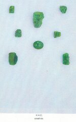
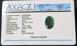
Those look like top quality emeralds. The emeralds that came off the 1622 Atocha were just as good as new after over 350 years under seawater. Since the Atocha sank just 17 years after the 1605 fleet, not much new will be learned. Whats so important about the San Roque? I heard the manifest lists 2,000 pounds of emeralds as property of the King. Do you have any idea what that is worth today?
The Atocha had two grades of emeralds from the Muzo mines. The dark green ones and what we called the "milky white" emeralds. If the wrecks are found of course Spain will claim them. No doubt.
The Atocha had two grades of emeralds from the Muzo mines. The dark green ones and what we called the "milky white" emeralds. If the wrecks are found of course Spain will claim them. No doubt.