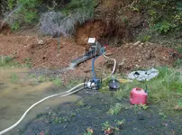
Early year rains have given an opportunity for early in the year work start

M.E.G.

Sr. Member
Apr 25, 2014
498
875
Primary Interest:
All Treasure Hunting
HPIM3552.JPG

HPIM3553.JPG

HPIM3554.JPG

HPIM3557.JPG

HPIM3558.JPG

HPIM3564.JPG

HPIM3559.JPG

HPIM3562.JPG
 

Attachments

  • HPIM3556.JPG
    HPIM3556.JPG
    1 MB · Views: 160
Upvote 0
OP
OP
M.E.G.

M.E.G.

Sr. Member
Apr 25, 2014
498
875
Primary Interest:
All Treasure Hunting
Nice looking bank material MEG. Are you hydraulicing with the blue hose?

Mike

The co-owner and I think so too. For the little bit of work in the pictured working area, it shows O.K. color so far. And yes, "hydraulicing" At that time it was just for testing the compaction of the material. As can be seen by the pics, the material is well compacted in the one pic, but not so much just feet away. Will be digging in with a hyraulic shovel soon.
 

OP
OP
M.E.G.

M.E.G.

Sr. Member
Apr 25, 2014
498
875
Primary Interest:
All Treasure Hunting
As can be seen by the first and third pic, there is about 8 feet of old channel gravels exposed to work, but in order to work them safely the dirt above (somewhere between 20 and 30 feet) has got to be move away. Just the little work done was bringing small amounts of dirt down on us.
 

ClaimStake

Full Member
Jul 27, 2015
198
233
Oroville CA
Detector(s) used
Gold Bug 2 (sold it)
Primary Interest:
Prospecting
that pond is a depression. a subduction point.

valley on one side, hill on the other, gold in between the pond and hill.
I know of many places like this. sometimes there's gold sometime there isn't.


nice spot keep digging.

are there anymore ponds like that nearby?

what state are you in.
 

Last edited:
OP
OP
M.E.G.

M.E.G.

Sr. Member
Apr 25, 2014
498
875
Primary Interest:
All Treasure Hunting
Last edited:
OP
OP
M.E.G.

M.E.G.

Sr. Member
Apr 25, 2014
498
875
Primary Interest:
All Treasure Hunting
This property is an old (late 1800s, early 1900s) hydrauliced area. I have found only one historicl picture of the workings at the time. History has it, water was brought to this location from miles around. There was about five acres of soil (red dirt clay), 20 to 30 feet in depth, washed from this location just to reach the old channel gravels.
 

ClaimStake

Full Member
Jul 27, 2015
198
233
Oroville CA
Detector(s) used
Gold Bug 2 (sold it)
Primary Interest:
Prospecting
if that's the case than that pond was never a pond. it was a small meadow turned into one.
 

Goldwasher

Gold Member
May 26, 2009
6,077
13,225
Sailor Flat, Ca.
🥇 Banner finds
1
Detector(s) used
SDC2300, Gold Bug 2 Burlap, fish oil, .35 gallons of water per minute.
Primary Interest:
All Treasure Hunting
recent geology is out the window when your working old diggins'. I see nothing that shows anything about meadows or valleys. Just the head of an old pit where the old timers left off. Looks like they've worked down about twenty feet from where their boots were first on the ground.
.
 

ClaimStake

Full Member
Jul 27, 2015
198
233
Oroville CA
Detector(s) used
Gold Bug 2 (sold it)
Primary Interest:
Prospecting
often times the old timers would use meadows pre existing ponds and other hard ground to hold the water.

also the grounds structural properties will remain the same as you dig down until you hit the next strata layer.

that whole area is an old volcano. the pond is where the ground implodes as the surrounding terrain explodes. this has the effect of concentrating the heavy materials into the high pressure points while ejecting the lighter materials into any voids(air) or low pressure areas.

just because you see cobbles or gravel doesn't mean it was worn by water. heat will do the same thing. things tend to spin around a lot in a volcanic eruption.

also here's some logic most people never seem to think about.
if a mountain erodes faster than it builds than it can not build.

in many places the ground is actually being pulled uphill. lites will erode faster than heavies.
and also lites accelerate and decelerate faster than heavies.

water flow has "absolutely" nothing to do with how the terrain gets shaped. the movement of the terrain determines the position of the creeks, rivers and washes.
not the other way around.

so if you think you're mining an ancient creek bed high and dry. chances are it's the bed of the creek nearby that got pulled up the hill.

if you find a nice pocket on the side of a hill with a lead traveling down. it's likely traveling up to that point and getting held up at a hard point in the terrain.

i'm currently working on a new theory in geology. our current understanding of the mechanical motion of the terrain is extremely lacking.

I don't want to highjack MEG's thread with this though.

and i'm still trying to get it all together right to really explain it in a simple way without going over people's heads too much.
has a lot to do with how volumes of materials kinetically/mechanically structure while moving and deforming.
a lot of fractal geometry and mechanics. it gets into it. and it works beautifully.
 

OP
OP
M.E.G.

M.E.G.

Sr. Member
Apr 25, 2014
498
875
Primary Interest:
All Treasure Hunting
Got to put some work toward exposing the old channel gravels before the rain started. It turns out they are a lot thicker than originaly thought, 16+ feet expose so far.
Hill side slid down trapping the bucket. It's an old machine, little under powered, so it took some work to got er free.
IMG_6038.JPG
IMG_6041.JPG

Dug out some hard pac:
IMG_6046.JPG

Pile of old channel material ready for processing:
IMG_6047.JPG
IMG_6048.JPG

Old channel gravels exposed 16+ feet up:
IMG_6049.JPG
 

Last edited:

Jeff95531

Silver Member
Feb 10, 2013
2,625
4,094
Deep in the redwoods of the TRUE Northern CA
Detector(s) used
Teknetics Alpha 2000
Primary Interest:
Prospecting
Is that the blue clay I've been studying about??? Now that I look closer...a mineral? I've yet to find it in my parts but it's a good time of year to go high mountain prospecting.
 

Last edited:

Goldwasher

Gold Member
May 26, 2009
6,077
13,225
Sailor Flat, Ca.
🥇 Banner finds
1
Detector(s) used
SDC2300, Gold Bug 2 Burlap, fish oil, .35 gallons of water per minute.
Primary Interest:
All Treasure Hunting
Austrailian residual deposit vs ancient alluvial gravel in Oregon. Thy are notably different. The Aussie video shows text book https://en.wikipedia.org/wiki/Eluvium . Meg Isn't showing his pile but, I'd put money on it that visually the gold looks quite different. Considering it is coming from an ancient alluvial gravel channel in Oregon. That happens to be part of a well known and significantly worked and studied region consisting of much of the same types of channels.
The volcanism and uplift occurring in the western U.S. and the different times that gravels were deposited are markedly different than the historic geology that has occurred in the Austrailian gold fields. There are similar deposits in the U.S. but, not the one shown in Megs video.
I bet when meg gets closer to bedrock he will actually be able to figure the direction those gravels were flowing by the way they are laid out "shingling". That is if he doesn't know already.(from existing reports and maps that exist) water has pretty much everything to do with it.
 

OP
OP
M.E.G.

M.E.G.

Sr. Member
Apr 25, 2014
498
875
Primary Interest:
All Treasure Hunting
Just before setting up and digging in:
HPIM3575.JPG
HPIM3578.JPG

Set up and shoveling away:
HPIM3583.JPG

Not to bad for a couple of hours:
HPIM3584.JPG

This material had a bit more clay than what the washing process could efficiently deal with one time through.
HPIM3585.JPG
HPIM3586.JPG
HPIM3588.JPG
 

Top Member Reactions

Users who are viewing this thread

Top