You are using an out of date browser. It may not display this or other websites correctly.
You should upgrade or use an alternative browser.
You should upgrade or use an alternative browser.
bernard romans map
- Thread starter keegah
- Start date


rgecy
Bronze Member
- Joined
- Jun 14, 2004
- Messages
- 1,910
- Reaction score
- 59
- Golden Thread
- 0
- Location
- Beaufort, SC
- Detector(s) used
- Garrett Sea Hunter Mk II
Here is the map at the Library of Congress. You can actually save the map and view it using a free viewer. It will also allow you to save a .jpg that can be printed. I believe you can also order copies!
Library of Congress - Bernard Roman - East Coast Florida
I take it that this is the map you were looking for. If not, just do a new search and should give you the results you need. There are several there.
How to Order Reproductions for American Memory Map Collections
Good Luck,
Robert
Library of Congress - Bernard Roman - East Coast Florida
I take it that this is the map you were looking for. If not, just do a new search and should give you the results you need. There are several there.
How to Order Reproductions for American Memory Map Collections
Good Luck,
Robert
ivan salis
Platinum Member
- Joined
- Feb 5, 2007
- Messages
- 16,794
- Reaction score
- 3,812
- Golden Thread
- 0
- Location
- callahan,fl
- 🏆 Honorable Mentions:
- 1
- Detector(s) used
- delta 4000 / ace 250 - used BH and many others too
fla state archives---has lots of maps---just got one copied and sent to me ---don't know if they have that one though ---holly at the state archives was quite nice to me ---told her it was for my "research"---Ivan
Darren in NC
Silver Member
- Joined
- Apr 1, 2004
- Messages
- 2,838
- Reaction score
- 1,735
- Golden Thread
- 0
- Detector(s) used
- Tesoro Sand Shark, Homebuilt pulse loop
- Primary Interest:
- Shipwrecks
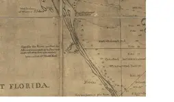
Here's a portion of the east coast map from Romans in 1774 (published 7 years later in 1781) including a notation about the 1715 fleet between Sebastian and St. Lucie's Inlet. If you need a specific part of the map, let me know. It's too big to see all at once.
Attachments
diverlynn
Hero Member
- Joined
- Oct 25, 2006
- Messages
- 699
- Reaction score
- 156
- Golden Thread
- 0
- Location
- New Smyrna Beach
- Detector(s) used
- Excalibur 1000
Darren,
Can you post a photo just south, Melbourne, where we are working?
Thanks,
Diverlynn
Can you post a photo just south, Melbourne, where we are working?
Thanks,
Diverlynn
Darren in NC
Silver Member
- Joined
- Apr 1, 2004
- Messages
- 2,838
- Reaction score
- 1,735
- Golden Thread
- 0
- Detector(s) used
- Tesoro Sand Shark, Homebuilt pulse loop
- Primary Interest:
- Shipwrecks
Actually, Lynn, Melbourne is already covered on the above map. If you'll look dead center of the map, Sebastian Inlet is there. Melbourne is just above there where the depths are recorded at 12. It's kinda hard to compare the old and new, eh? ")
Chagy
Bronze Member
Peg Leg said:I can count about 14 X's on the map south of Sabastian Inlet.
If these were/are shipwrecks there are a good number of them under the beach sand and no longer in the ocean.
Very interesting.
Peg Leg
Peg,
the "x" are obstacles (not wrecks) in this case maybe the reef......
Chagy......
diverlynn
Hero Member
- Joined
- Oct 25, 2006
- Messages
- 699
- Reaction score
- 156
- Golden Thread
- 0
- Location
- New Smyrna Beach
- Detector(s) used
- Excalibur 1000
Duh
stevemc
Bronze Member
- Joined
- Feb 12, 2005
- Messages
- 2,121
- Reaction score
- 279
- Golden Thread
- 0
- Location
- Sarasota, FL
- Detector(s) used
- Whites Surfmaster PI Pro and Whites Surfmaster PI, Minelab Excal NY blue sword. 2 White's Dual field pi, Garrett sea hunter pi II (but don't use it for obvious reasons) 5' x 3 1/2' coil underwater Pi
- Primary Interest:
- Shipwrecks
Yep, what Chagy said. Those are on modern charts also. They represent either exposed area at low tide or very shallow area at low tide, usually with rocks. That coast has some shallow reefs and sandbars North and South of Sebastian Inlet. But what Peg Leg said about some of the wrecks being under the sand is true. Some of the wreckage is under sand on land. Either the boats unloaded all the ballast and heavy cargo, and rolled up on the beach and later went below the sand, or the shoreline has moved out, onto the wrecks. I follow the latter theory. A well documented wreck on land is the 1715 wreck that is called Corrigans (for the original homebuilder) that is under the sand. There was cannons dug up when they were digging the foundation for a house in the 1940s, and then when they built the condos that are there now, they had lots of artifacts come up with the digging.
SEAHUNTER
Hero Member
- Joined
- Jan 10, 2006
- Messages
- 841
- Reaction score
- 110
- Golden Thread
- 0
- Location
- PALM BEACH COUNTY,FLORIDA
- Primary Interest:
- All Treasure Hunting
Hi Darren
Do you have the part that would show Jupiter and the surrounding area?
Scott
Do you have the part that would show Jupiter and the surrounding area?
Scott
Darren in NC
Silver Member
- Joined
- Apr 1, 2004
- Messages
- 2,838
- Reaction score
- 1,735
- Golden Thread
- 0
- Detector(s) used
- Tesoro Sand Shark, Homebuilt pulse loop
- Primary Interest:
- Shipwrecks
Twisted Fork
Hero Member
Some discrepancies are intentional to produce a fold and new quads underneath it all. Just a thought. Twisted
PyrateJim
Full Member
- Joined
- Nov 28, 2004
- Messages
- 224
- Reaction score
- 7
- Golden Thread
- 0
- Location
- Sterling Hts., MI.
- Detector(s) used
- Garrett, Sea Hunter mark II
Found what I needed.
Thanks
Thanks
rgecy
Bronze Member
- Joined
- Jun 14, 2004
- Messages
- 1,910
- Reaction score
- 59
- Golden Thread
- 0
- Location
- Beaufort, SC
- Detector(s) used
- Garrett Sea Hunter Mk II
http://memory.loc.gov/cgi-bin/map_item.pl?data=/home/www/data/gmd/gmd386/g3861/g3861p/ar16220a.sid&style=gmd&itemLink=D?gmd:1:./temp/~ammem_bN50::&title=Maps%20of%20East%20and%20West%20Florida.%20B.%20Romans,%20inv.%20delin.%20%26%20in%20%26AElig;re%20incidit.
If you cant get to it by the link above, use this one and do a search on All Collections. Type in "Florida Bernard Roman".
http://memory.loc.gov/ammem/gnrlmapquery.html
Here is the map info from the LOC.
MEDIUM
2 maps on 3 sheets 237 x 80 cm. or smaller fold. in cover 64 & 48 cm.
CALL NUMBER
G3861.P5 s500 .R6 Vault
REPOSITORY
Library of Congress Geography and Map Division Washington, D.C. 20540-4650 USA
DIGITAL ID
(Map 1) g3861p ar16220a http://hdl.loc.gov/loc.gmd/g3861p.ar16220a
(Map 2) g3931p ar16220b http://hdl.loc.gov/loc.gmd/g3931p.ar16220b
Let me know if you need any help.
Robert
PyrateJim
Full Member
- Joined
- Nov 28, 2004
- Messages
- 224
- Reaction score
- 7
- Golden Thread
- 0
- Location
- Sterling Hts., MI.
- Detector(s) used
- Garrett, Sea Hunter mark II
Thanks. Just downloaded the map and viewer and all is working fine. Trying to find out what it costs to obtain a full size, printed copy of the map. Any ideas?
rgecy
Bronze Member
- Joined
- Jun 14, 2004
- Messages
- 1,910
- Reaction score
- 59
- Golden Thread
- 0
- Location
- Beaufort, SC
- Detector(s) used
- Garrett Sea Hunter Mk II
Not sure what the cost might be, but here is where you can start.
http://memory.loc.gov/ammem/gmdhtml/gmdorder.html
http://memory.loc.gov/ammem/gmdhtml/gmdorder.html
PyrateJim
Full Member
- Joined
- Nov 28, 2004
- Messages
- 224
- Reaction score
- 7
- Golden Thread
- 0
- Location
- Sterling Hts., MI.
- Detector(s) used
- Garrett, Sea Hunter mark II
Thanks. I went through that and never once saw any prices. Looks like you have to call them, tell them what you want, and then they quote you a price. I'll be calling on thursday.
signumops
Hero Member
Keegah:
The Atlantic Pilot written in 1772 by De Brahm containing all of his charts in fold-out bright white paper was reproduced by the FL. State Univ. System as a Bicentennial reproduction in 1972. The book is an exact reproduction, down to the typefaces and yellow text pages. The charts are excellent.
Alibris had a copy available this evening for $11.00
Top Member Reactions
-
 2294
2294 -
 1520
1520 -
 1369
1369 -
 1304
1304 -
 1122
1122 -
 1038
1038 -
 972
972 -
 792
792 -
 762
762 -
 607
607 -
 567
567 -
 552
552 -
 525
525 -
 499
499 -
 480
480
Similar threads
- Replies
- 13
- Views
- 2K
- Replies
- 2
- Views
- 201
Users who are viewing this thread
Total: 1 (members: 0, guests: 1)
