1826 Map of the NATIONAL ROAD

jeff of pa

Super Moderator
⛭ Moderator
🥇 Charter Member
Joined
Dec 19, 2003
Messages
90,075
Reaction score
65,694
Golden Thread
2
🥇 Banner finds
1
🏆 Honorable Mentions:
1
Primary Interest:
All Treasure Hunting

Attachments

  • z3.webp
    z3.webp
    94.7 KB · Views: 1,840
do you know what book this came from? the digital resolution makes some symbols hard to interpret.
 

no i just have (purchased) the photo copied map
 

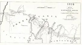
National road is currently US 40, but there are many modernized sections of the road. I live on a section of Old National Road that was cut out of Rt. 40 due to I-70. There are many historical places along US 40, many near me that are old "forts' for keeping the American Indians to the west. The closest one was Miller's Blockhouse. I know where it used to stand (now a PA FBC lake) and its cemetery that has victims of the Easter Massacre. Cemetery has been preserved and has a stone monument, but is difficult to get to since you are prohibited to have motorized vehicles back near it. First time I went back there I got lucky and FBC employees were working on the roadway leading back to it and the gate was unlocked and was able to get verbal permission to drive my van back to the cemetery and blockhouse site. I currently MD and hike back there during the hunting off-season. I have found lots of artifacts and have donated them to the Washington County Historical Society since I have a strong belief that they would have more of a educational value than me hording them for myself. If anyone is interested in this and any other old cemeteries or even detecting at an old county poor farm just outside PA in Ohio County WV let me know. I have permits for both areas, though entering any structures is prohibited due to safety issues including asbestos.
 

here is another Try at a clearer pics of the map using my Digital camera instead of Scanner

DSCF0009.webp


DSCF0003.webp

DSCF0004.webp

DSCF0005.webp

DSCF0011.webp
 

much clearer pics jeff. I will try to get some pictures of the miller blockhouse site and its current cemetery this weekend if the weather holds....forecast snow today and a lot of it! its a 2 mile hike to the cemetery and old day use area where the blockhouse stood but the 300 year willows that shielded the home are somewhat there but damaged from windstorms this past year. Wish I knew where the outhouse was...I find a lot of stuff in outhouse locations and springhouses.
 

much clearer pics jeff. I will try to get some pictures of the miller blockhouse site and its current cemetery this weekend if the weather holds....forecast snow today and a lot of it! its a 2 mile hike to the cemetery and old day use area where the blockhouse stood but the 300 year willows that shielded the home are somewhat there but damaged from windstorms this past year. Wish I knew where the outhouse was...I find a lot of stuff in outhouse locations and springhouses.

Yea Ill be Watching & Good Luck.

10" or so over night tonight, another storm in a few days

& Sub 0 temps till Who knows When are predicted for here :(
 

Sorry i havent posted in awhile but work has been hectic. i just got a Legacy 3500 detector and will be gaining a permit to MD the Miller Blockhouse site. Since this sits on PAFBC (Pennsylvania Fish and Boat Commission) property all finds will be donated to local museums to enrich residence of our rich history locally. I will also note that there is a mass burial of Native Americans here as well. I have posted some pictures of the cemetery though i will not give out its exact location to keep the cemetery from being wrongfully vandalized. Somebody has put lots of money and time into keeping the cemetery maintained. Here are the pictures of the cemetery and the location of the blockhouse (now an unused day use area). Enjoy!

Shelby at home 033.webpShelby at home 034.webpShelby at home 035.webpShelby at home 036.webpShelby at home 037.webpShelby at home 038.webpShelby at home 039.webpShelby at home 040.webpShelby at home 041.webpShelby at home 042.webp


As of January 16th, 2015, from a reply from Harrisburg, via PA Fish and Boat, Department of Conservation of Natural Resources (State Parks bureau), it is ILLEGAL TO METAL DETECT or DISTURB ANY GROUND and habitat. Meaning MD is not allowed. Pulled some strings with my old employer (DCNR) to get a quick description of what was allowed and pretty much things are to be left as they are including surface items. Those must be left as well. It is unfortunate that they replied this way towards me considering i donate every find to local historical societies and museums.
 

Last edited:
Near Cumberland Md., not far from the Pa. state line, is a portion of the original national road, not the Rt. 40 portion. It is called the Old Hancock Road. One end has been cut off by the construction of the lake at Rocky Gap State Park and the other end has been cut off by I-68. It crosses Rocky Gap Road and Mt Pleasant Road. It continues through the woods at the church and stops at the end of the ridge towards I-68. Coordinates are 39°41'15.90"N 78°41'7.61"W There are other portions in LaVale Md. I know these are not Pa. locations, but they are close.
 

Top Member Reactions

Users who are viewing this thread

Back
Top Bottom