1320
Silver Member
- Joined
- Dec 10, 2004
- Messages
- 3,436
- Reaction score
- 2,311
- Golden Thread
- 0
- Location
- East Central Kentucky
Black Smith shop
Looks like the drawing is the fort to me, BS Sh is probably an abbreviation for a family name, looks like the full name would not fit in the space provided by the dot (the home), thats how i would read it.
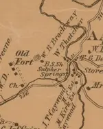
Tedyoh got it, it is the first 2 initials of the land owners name, the last name is blocked out by the roadway intersection. It could be for example something like B. S. Shoals. It is not quite like an old plat map but it is using the same type of boundary names.
I'm going with black smith also. I have a civil war era map and it has BS all over the place. I first thought it stood for boys school, but soon proved that was not it.