What's new

1937 Aerial Photos of Illinois

Fryy

Jr. Member
Joined
Jun 4, 2008
Messages
24
Reaction score
0
Golden Thread
0
Location
Naperville, IL
In 2001 I was a prepress tech for Scantech Color Systems in Champaign Illinois. We were asked to scan aerial photos which were taken as far back as 1937. When I left this position they were just finishing up Champaign County. Last month I was amazed to find they had scanned a good portion of Illinois. More amazed to find access to them on the web.
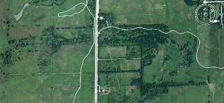
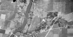
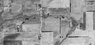
So I brought up my county and was able to figure out where I was in they old photo. When I compared it to aerial photos today, well, looks like I’ll be busy for quite sometime. We have a prairie path close to my house and had noticed traces of old roads before. So I compared those shots as you see below. I had to share this and hope it gets you Illinoisans planning your next trip. If you notice in the pictures below I now have 5 sites to explore. The white curving lines are bike paths.
Happy hunting.

http://www.isgs.uiuc.edu/nsdihome/webdocs/ilhap/county/

Let me know if you strike it rich!
 

Attachments

  • 1939.webp
    1939.webp
    49.5 KB · Views: 820
  • 2008.gif
    2008.gif
    232.9 KB · Views: 799
Thanks for the post. . . and welcome to TNET!

It's amazing what 70 years will do to the landscape :wink:

HH!
 
Yep, they've been out for a couple years now and I've used them to hit some old racetracks, fairgrounds etc.. Good stuff!
 
Welcome to the forum!

I can't wait until they post Franklin county - any clue as to whether or not it was ever photographed?
 
Thanks! I got the SID viewer. Now I need to figure out how to interpret the index file so I can figure out where I'm at on the map. For instance, I'm trying to figure out which one of the SID files I download for Oswego, IL (kendall county).
 
Hey Rootmaster,
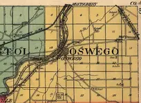
You'll notice on the line index that Oswego is in the upper right central part of the county, and the numbers in the index are repeated on the main photo page for the county. In this case, Oswego is in the second row of numbers, at #28/29. Cross reference to the IlGenWeb site for Kendall County can bring up an old twp map, in the case here 1922, so it's close to the time of the photos.

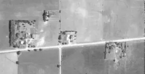
Now start at Oswego, then go back and select adjoing photos in what ever direction you want to search, NSEW for example. I moved to the right, or east to find an shot of the old church and school at Wolf's Crossing.

Then bring up mapquest, terraserver, google earth or whatever modern aerial image you want to determine the current look of the site, which you probably already know.

http://landplats.ilsos.net/FTP_Illinois.html
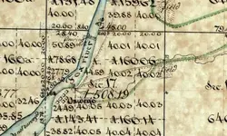
Check this site for the view from 100 years earlier, showing the original dam and flour mill on the river and the road to Naperville.
 

Attachments

  • Oswego North.webp
    Oswego North.webp
    65.1 KB · Views: 719
  • OswegoTwp1922.webp
    OswegoTwp1922.webp
    73.9 KB · Views: 695
  • Wolf\'s Crossing.webp
    Wolf\'s Crossing.webp
    24.3 KB · Views: 669
  • old Oswego.webp
    old Oswego.webp
    51.7 KB · Views: 680
Nice job Lowbatts :thumbsup:, nice to see the same enthusiasm with these photos.
Kimsdad, let us know when you hit the mutha load! :icon_king:
 
Thanks VERY MUCH Lowbatts!! I'm definitely going to spend some time looking for old sites with this.

One more question, how do you view the line index? I was opening the files in a hex editor and trying to figure out what they were.
 
Thanks for posting the great info, Fryy!

Best,
rmptr
 
Rootmaster, once you have the MrSid viewer, it will open the line index as it does the other pics.

Hey Fryy, you did great work on this stuff man! I would love to see more. Do you know if only the currently listed 62 counties are it? Will there be more in the future? Is the work still ongoing?
 
I emailed them and asked about other counties that aren't listed yet. They said thad the entire state was photographed, but that they ran out of funding to do the rest of the scanning.
 
Did you ask about the availability of the remaing pics? There a few spots I'm crazy to see that aren't done.
 
Wow. This is awesome. I can compare apples to apples with google earth and locate the older buildings where I'm from (62665). Absolutely invaluable. Who knew these were out there.

Ty
 
Hey fellows, a little help here. I downloaded the MrSid trial software, but can't get anything to come up on that site. Granted, I am not computer savy. Any help would be appreciated (just keep it simple). :wink:
 
Casull said:
Hey fellows, a little help here. I downloaded the MrSid trial software, but can't get anything to come up on that site. Granted, I am not computer savy. Any help would be appreciated (just keep it simple). :wink:

You have to download the files one at a time and open them in the MrSid viewer. Start with the index and then figure out which numbers you need based on where you are at on the index. You should start with a well known city in the corner of the county or something to get your bearings. Good luck!
 
You have to download the files one at a time and open them in the MrSid viewer. Start with the index and then figure out which numbers you need based on where you are at on the index. You should start with a well known city in the corner of the county or something to get your bearings. Good luck!

I'll give that a try. Thanks. If it doesn't work, I guess I can always ask my teenage daughter for help. ;D
 
Yep, nowadays I take the kid along when someone needs computer help. If it's application-oriented, I tell her to dive in. She knows where the help buttons are!
 

Users who are viewing this thread

Back
Top Bottom